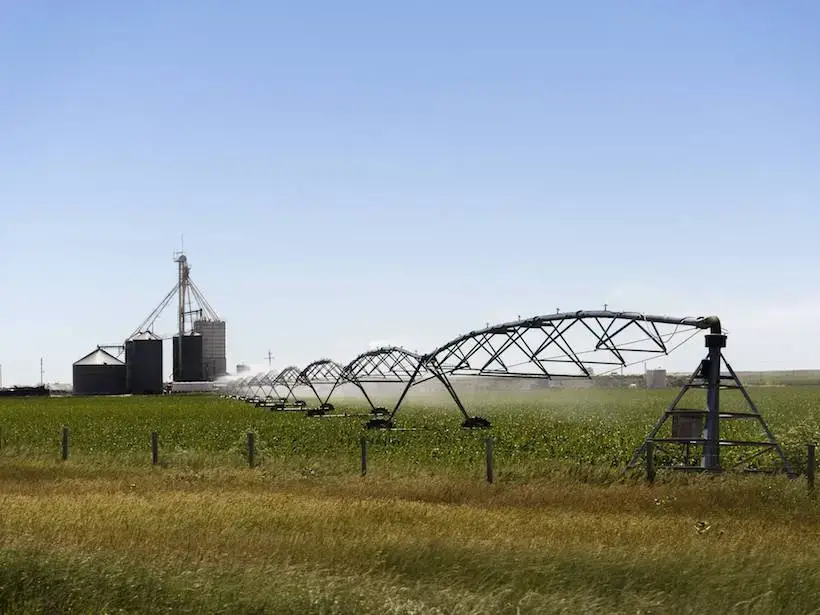
Underground sources of water like aquifers are becoming limited through different areas of the country due to drought and usage and even the biggest supplies of water like the Ogallala Aquifer which is the biggest aquifer in the US have seen drops in levels. What is the Ogallala Aquifer?
The Ogallala Aquifer or High Plains Aquifer is an unconfined aquifer & principal source of H2O for agricultural regions in the US underlying an area of 174,000 square mi. extending through 8 states in the Midwest providing drinking H2O to 2.3 million people with recharge coming from rainwater & snowmelt.
The Ogallala Aquifer also known as High Plains Aquifer is a shallow water table aquifer surrounded by sand, silt, clay, and gravel located beneath the Great Plains in the United States providing irrigation along with drinking water.
Where is the Ogallala Aquifer
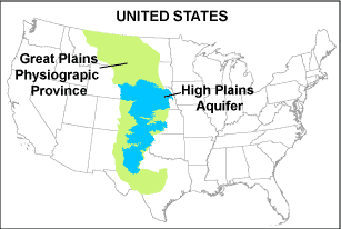
The Ogallala Aquifer that’s better known as High Plains Aquifer underlies an area of about 174,000 square miles that extends through parts of eight states of the Midwest United States. Soil Deposition of the Ogallala Aquifer formation began 10-12 million years ago Soil types include sand, gravel, silt, and clay.
The High Plains Aquifer system consists of Tertiary sedimentary rock, dominantly sandstone and gravel eroded from the ancient Rocky Mountains, and deposited in the Tertiary period from about 31 to 5 million years ago. The Ogallala Formation is the primary aquifer unit in the system.
The High Plains (Ogallala) is an unconfined aquifer, and virtually all recharge comes from rainwater and snowmelt. As the High Plains has a semiarid climate, recharge is minimal.
This aquifer is the largest aquifer and principal source of water in the United States. The USGA estimates that there are somewhere around 980 trillion gallons of water in the High Plains aquifer.
About 10 million years ago the Rocky Mountains were twice the height as they are today. Great amounts of water carried sediments that flowed from the mountains and fill in the channels that were carved out years before.
This changed the shape of the aquifer, especially in the southern portion where there are depths of 30 feet or less of what’s called Saturated Thickness (the vertical thickness of the hydrogeological defined aquifer in which the pore spaces of the rock forming the aquifer are filled saturated with water) in Texas while much more northern area.
The High Plains underlies approximately 33,500 square miles of 46 counties in western and south-central Kansas and is present in seven other states in the Great Plains region of the United States. Depth below the land surface to the base of the aquifer is over 500 feet in parts of southwestern Kansas.
The High Plains aquifer consists of one or more hydraulically connected geologic units of late Tertiary or Quaternary age, underlain by bedrock units that range in age from Permian to Tertiary. The High Plains aquifer is divided into the northern, central, and southern High Plains regions.
The northern High Plains aquifer underlies parts of Colorado, Kansas, Nebraska, South Dakota, and Wyoming. The central High Plains underlies parts of Colorado, Kansas, New Mexico, Oklahoma, and Texas. The southern High Plains aquifer underlies eastern New Mexico and northwestern Texas.
What is an Aquifer
An aquifer is a body of porous rock or sediment saturated with groundwater. Groundwater enters an aquifer as precipitation seeps through the soil. It can move through the aquifer and resurface through springs and wells. Aquifers are a major source of around 1.5 billion people of water today worldwide.
Aquifers are made up of material that lets water in easily and can also be stored. Depending on the location of the aquifer will determine what kind of material its made from. Layers of clay and rock like shale can act like a barrier holding groundwater. The most common materials naturally formed in an Aquifer are sand and gravel they make up about 80% of all aquifers in the US. They are shallow and susceptible to contamination.
There are two types of aquifers confined and unconfined.
- Confined aquifers or Closed is made up of a layer of impenetrable rock or clay above them bounded above and below.
- Unconfined aquifers or Open lie below a permeable layer of soil and are connected to the surface.
A Confined aquifer is an aquifer below the land surface that is saturated with water. Layers of impermeable material are both above and below the aquifer, causing it to be under pressure so that when the aquifer is penetrated by a well.
Artesian Wells can be formed in a Confined Aquifer by groundwater under pressure flowing to the surface without the need for a mechanical pump. When a water well is bored into an Artesian Well, water is found sandwiched between two layers of impervious rock that acts as a reservoir it is normally high quality and clean.
The water will rise above the top of the aquifer. This type of aquifer is recharged by stream flow and precipitation trickling down through cracks and underground springs.
An Unconfined Aquifer fils easily from groundwater and is in direct contact with the atmosphere through the open pore spaces of the overlying soil or rock, then the aquifer is said to be unconfined. The greater the water table the higher level in the Aquifer. There is also a chance of a decline in the water table depth if groundwater is used faster than its recharged.
The upper groundwater surface in an unconfined aquifer is called the water table. The depth of the water table varies according to factors such as the topography, geology, season and tidal effects, and the quantities of water being pumped from the aquifer.
Unconfined aquifers are usually recharged by rain or streamwater infiltrating directly through the overlying soil. Water flows down from above until the level in the Aquifer is full. Typical examples of unconfined aquifers include many areas of coastal sands and alluvial deposits in river valleys.
Many of these Aquifers are made from sandstone very common in the Rocky Mountains, Appalachia, and the Midwest regions while other aquifers are also made from Limestone in states like Florida Ohio, and Missouri.
Water availability is the quantity of water that can be used for human purposes without significant harm to ecosystems or other users. Consideration is given to demands from human and ecosystem needs, equitable apportionment of water among uses, and indicators of stress to the water resource. ……………………………………………………………………………… Read more
How Deep is the Ogallala Aquifer
Under natural conditions, the water table of an unconfined aquifer will rise and fall as a function of recharge, discharge, and evaporation or transpiration.
 Since the late 80’s the High Plains Aquifer has been monitored for levels in all the states that it lies in. Researchers say that there are 1 ft of water that is depleted each year from the aquifer. Kansas in the northern end saw the biggest drop in water with up to 2 ft depleted.
According to the USGS– water-level changes in the High Plains aquifer from 1980 to 1995 were based on water levels from 5,783 wells. Area-weighted, average water-level change from 1980 to 1995 for the aquifer was a decline of 2.0 ft.
Water-level changes in the High Plains aquifer from 2000 to 2005 were based on water levels measured in 7,248 wells. Average water-level change from 1980 to 1995 by State ranged from a decline of 6.6 ft in Kansas to a rise of 1.1 ft in Nebraska.
The High Plains Aquifer underlies approximately 33,500 square miles of 46 counties in western and south-central Kansas whose water demand of 75 % is taken from the Ogallala and is present in seven other states in the Great Plains region of the United States.
Depth below the land surface to the base of the aquifer is over 500 feet in parts of southwestern Kansas. By studying the past researchers are able to project what may be the Saturated Thickness in the future. By measuring the depth of Water Wells every 2 years the High Plains Aquifer can be monitored.
The High Plains Water-Level Monitoring Study (HPWLMS) was created is the USGS in response to a directive from Congress to report on water-level changes every 2 years in the High Plains (Ogallala) aquifer.
In 1986 a directive by the Congress States of the High Plains region is authorized and directed to monitor the levels of the Ogallala (High Plains) Aquifer, and report annually to Congress. Monitoring is done daily on Interactive Maps provided by the High Plains Water Conservation District.
Is there a Water Scarcity in America?
Scientists say yes studies show:
H2O sources in the US won’t last 5-10 yrs.
Colorado River (drying up) from overuse
Lake Mead in Cal. provides H2O to over 22 million people in the Western US is (drying up)
Eastern Maryland (Salt Intrusion)
Nevada (draught)
New Mexico(draught)
Flint Michigan (infrastructure) .…………………………………………………………………………………………………………… Read more
They are called Water Grabbers the elite Billionaires, Investment Corporations, and International Mega Banks that use the Courts, Water Rights, Privatization, Wealth, and the Global Water Crisis to capitalize on their own interests. .………………………………………………………………………………………………… Read more
JimGalloway Author/Editor
![]()
References:
Earth Eclipse-Aquifer: Where are they found, Types and How they Work
The High Plains Water Conservation District
The USGS-High Plains Aquifer