Living a couple of miles from the Delaware River all my life I have seen its beauty and have seen its fury. The Delaware River is the background here in parts of Pennsylvania, New York & New Jersey and runs and ends into the Delaware Bay separating the South Jersey Shore and the state of Delaware. Where does the Delaware River start?
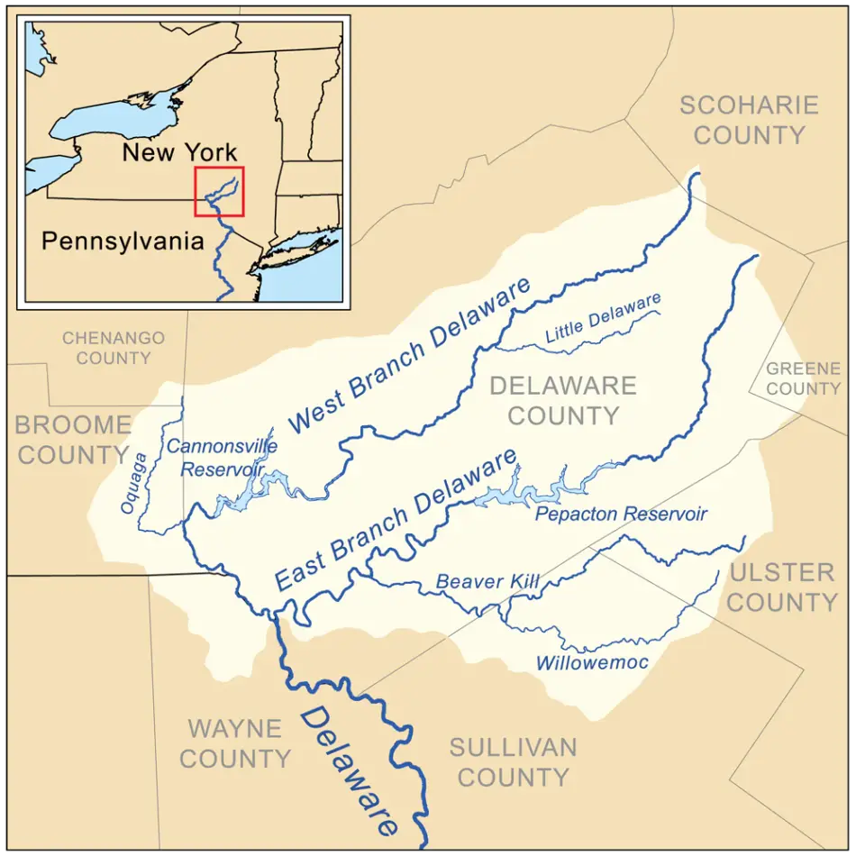
The Delaware River begins in 2 branches in the Catskill Mountains of New York. The Western Branch of the Delaware River starts near Mount Jefferson, & the Eastern Branch begins near Roxbury at Grand Gorge. Both branches of Delaware merge in Hancock, NY, & flow as 1 river down to Delaware Bay.
If you live for the outdoors as my family does there is no more beautiful spot in the world than the location where I live one hour-20 minute you could be in the Pocono Mountains at the Water Gap fishing for freshwater trout or 1-20 minutes hour south on the Delaware Bay fishing for Weakfish and Blues. This is why I never knew that there was more river above the Water Gap on the Great Delaware River.
Where Does the Delaware River Start
The Delaware River begins at the confluence of the East Branch Delaware River and West Branch Delaware River in the Catskill Mountains of New York. These two branches join near Hancock, New York, forming the main stem of the Delaware River, which then flows southward through several states, including Pennsylvania, New Jersey, and Delaware, before emptying into the Delaware Bay. The river’s source is approximately 1,969 feet (600 meters) above sea level in the mountains.
Whether you’re a geography enthusiast or simply someone fascinated by history, and nature’s remarkable formations, understanding where famous rivers start, like the Delaware River tells the story of America.
The Delaware River is recognized as one of the major rivers on the Eastern Coast of the United States, the Delaware River has a rich history and an intricate path. Though popular, few realize the exact location where this impressive tidal river begins.
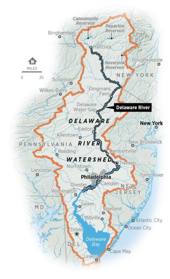
Join us on an enlightening journey as we explore the genesis of the historical Delaware River and its watershed, its significant geographies, and its impact on the communities that it nourishes along its 331-mile course.
The Start of the Delaware River and Its Watershed
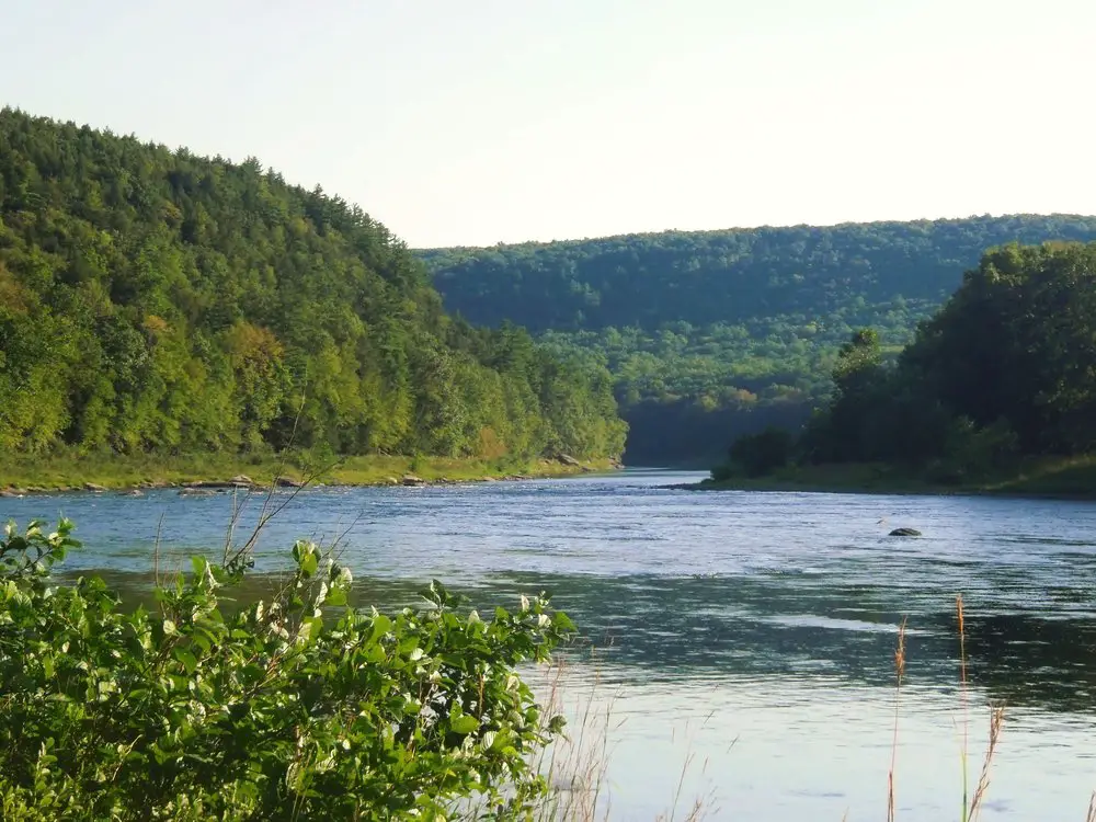
The headwaters of the Delaware River are located in the Catskill Mountains of New York, where the East Branch Delaware River and West Branch Delaware River converge near Hancock. This confluence marks the beginning of the main stem of the Delaware River, which flows southward through diverse landscapes. The watershed of the Delaware River encompasses various ecosystems and plays a crucial role in providing water resources for communities across four states—New York, Pennsylvania, New Jersey, and Delaware.
The Delaware River, an outstanding natural marvel, eventually makes its way into the Delaware Bay, providing a ceaseless flow of beauty and aquatic life along its path. Settled in the heartland of two US states, the river’s start is unique: it sprouts from two principal branches with tributaries nesting in the Catskill Mountains of New York.
 This phenomenal waterway, known as the Upper Delaware, spans hundreds of miles and bisects the natural landscape, breathing life into the surrounding terrain. The American River’s impressive length and intricate watershed encompass multiple states, and its tributaries fork out like the arms of a sea star, each with its own unique ecosystem.
The Delaware River’s watershed, covering thousands of square miles, intertwines with several states, illustrating the river’s considerable influence across the eastern seaboard. As the river winds its way through the landscape, the waterway’s path distinguishes itself through the Delaware Water Gap, a spectacular geological feature that acts as a natural testament to the river’s power and endurance.
The Delaware River’s watershed, quite expansive, hosts numerous tributaries that capillary off the main body, feeding smaller streams and creeks while promoting biodiversity throughout its range.
Tidal influences in the Delaware River perpetually shift the water’s direction and depth, instilling a dynamic aquatic environment that ebbs and flows with the cycles of the moon. Freshwater meets saltwater in an estuarine dance, creating an incredible biodiverse hub in the river’s lower stretches. As the river navigates through miles and miles of diverse terrain, from the steep slopes of the Catskill Mountains to the low-lying swampland near Delaware Bay, its tidal influence dwindles, but it still leaves an indelible mark on the river’s landscape.
This incredible pathway, starting in the Catskill Mountains, flowing through various states contributing to various rivers, and finally emptying out into the Delaware Bay, is a testament to the Delaware River’s legacy. Thousands of miles pass under the river’s flow, and with every mile, the river carves out a unique story into the landscape.
With every trickle and gush, it starts new lives, supports countless ecosystems, and nourishes millions. It’s a ‘river’ of monumental importance, but also simply a ‘river’ with a story to tell a story that starts with two branches in the Catskill Mountains and eventually flows into Delaware Bay.
In essence, the Delaware River’s watershed, veining through various states, is a hydrological wonder. The river’s course, full of starts and finishes, challenges and triumphs, reflects the ebb and flow of life itself. The states it passes through, the miles it traverses, the Catskill Mountains at its birth, and the Delaware Bay at its maturity – all are testament to the river’s integral role in shaping the landscape, from the Upper Delaware River to the Delaware Water Gap, changing tidal waters and tributaries along its path.
Exploring American Rivers: The Start of the Delaware River
Exploring the origins of the Delaware River unveils its starting point in the scenic Catskill Mountains of New York, where the East Branch Delaware River and West Branch Delaware River merge near Hancock. This confluence marks the beginning of a remarkable journey for the river, as it winds its way through diverse landscapes and ecosystems.
The start of the Delaware River not only showcases the natural beauty of the Catskills but also initiates a significant watercourse that travels through multiple states, contributing to the rich tapestry of American rivers.
As an essential part of the American rivers’ network, the Delaware River has a fascinating history and vital ecological role. Originating in New York from the junction of the East and West Branches, the river’s journey begins, stretching over 300 miles before it empties into the Delaware Bay, eventually leading to the Atlantic Ocean.
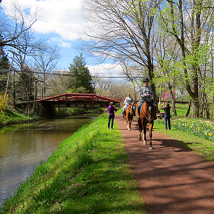
This river’s unique attribute is that it remains one of the few undammed rivers in the US, keeping its free-flowing character while serving as a source of fresh, clean water for millions of Americans. Whether it’s the Philadelphia cityscape or the Delaware Canal’s charming paths, the river’s picturesque route is a wonder to behold.
The Delaware River doesn’t just supply water; it plays an essential role in sustaining various ecosystems. From the cold river water of its upper stretches, home to trout and other cold-loving species, to the warmer, nutrient-rich Delaware water of the estuary, this river supports a diverse range of aquatic life. It’s not just about the Delaware water at surface level, either. The areas surrounding the river, such as the Delaware Canal, offer a lush habitat for numerous plants and animals.
For those who are adventurous, there’s more to see beyond the river’s surface; jump in a kayak and leisurely travel down the Delaware water channel. Trailing alongside the Delaware Canal offers a peaceful escape in nature, a spotlight on the beauty and diversity of American rivers. The Delaware River’s influence extends far past its banks, affecting the surrounding American communities and shaping the regional landscape.
But let’s not forget its influence on the Atlantic. The Delaware River is a significant player in the broader Atlantic ecosystem. Its river water contributes to the salinity balance of the Atlantic Ocean, influencing the health of marine life. Moreover, the freshwater outflow promotes robust fisheries near the Atlantic coast a boon for local economies and a testament to American conservation efforts.
Rushing down from the New York mountains, through the Delaware Canal, before finally finishing its race into the Atlantic, the Delaware water sets a wonderful example of uninterrupted, free-flowing American rivers. Through this overview, hopefully, it’s clear that the Delaware River is not just an American river, but also an American treasure.
Understanding The Delaware River Basin Center
The Delaware River Basin Center serves as a focal point for understanding and managing the Delaware River Basin’s complex ecosystem. This center plays a vital role in coordinating research, conservation efforts, and policies to sustainably manage the resources within the basin, ensuring the health of the Delaware River and its surrounding areas.
If you’re looking for facts, the Delaware River Basin (DRBC) doesn’t disappoint; it’s a vital part of the Delaware River story. Forming part of the river’s management mechanism, it oversees the river port and continually monitors the river’s health. With its office in West Trenton, NJ, the DRBC is responsible for managing the river’s shared resources.
 The Delaware River Basin encompasses a significant area, with the Delaware River serving as its lifeblood. Its clean waters nourish not only the numerous rivers within the area but also the various ecosystems that rely on them.
You’ll find the center constantly working not only to maintain but improve the river’s cleanliness. Their ethos is ‘clean rivers lead to a healthy environment.’
But what is the Delaware River Basin Center, you ask? Well, it’s part of the larger Delaware River Basin management structure. With the Delaware River at its core, the Delaware River Basin includes the main river, its numerous tributaries, and the basin’s inhabitants. Its management is essential to ensure the river’s rich resources don’t get depleted.
For those in NJ and across the mid-Atlantic region, the Delaware River is more than just a body of water; it’s a vital artery. That’s where the DRBC steps in. With a commitment to maintaining the integrity of the Delaware River Basin, the DRBC dedicates attention to every tributary and the main river’s port.
A key part of understanding the Delaware River is recognizing the significance of the Delaware River Basin Center. The Center manages everything within the Basin, from the Delaware River and its various tributaries to the river port. They ensure the river remains clean, which in turn promotes thriving ecosystems throughout the Basin and the rivers within it.
The Delaware River Basin Center continues to monitor the numerous rivers within the Basin. In doing so, they maintain balance and ensure each river, including the Delaware, remains clean. Besides maintaining cleanliness, they also regulate the activity at the river port and manage the entire Basin with professionalism.
The Delaware River’s significance within the Basin is immeasurable. It feeds numerous smaller rivers, provides a conduit for important shipping at the river port, and serves as a key resource for the folks in NJ and those in mid-Atlantic states. The Delaware River Basin Center, as part of the larger Delaware River Basin management, ensures the river’s life-giving properties are utilized responsibly.
Basically, the Delaware River Basin Center is at the heart of the Delaware River’s life, its geometric ‘center,’ if you will. Engaged in the river’s continuous management, including oversight of the river port, the Center is key to maintaining the Basin’s cleanliness and its resources. With the mid-Atlantic depending heavily on the Delaware River and NJ being a direct beneficiary for miles, the center role can’t be overemphasized.
So, we hope you now understand the important role the Delaware River Basin Center plays in managing the Delaware River, the various rivers within the Basin, and maintaining the river port. It’s a role that’s about cleanliness, management, and sustainability. Their fact-based approach helps keep the Delaware River Basin, a significant part of NJ, Delaware the mid-Atlantic region, clean and productive.
Key Aspects to Discover about the Delaware River Start Basin
Nestled within the diverse geographical terrain of Pennsylvania, the Delaware River starts. It’s an essential waterway that courses through the heart of the “Keystone State,” providing sustenance and support to many communities along its path. As the largest un-dammed river on the Atlantic Seaboard of the U.S., the Delaware River’s clean waters have played a significant role in shaping the cities and towns that have sprung up along its banks.
Some Key Aspects of the Delaware River and its Basin:
Nestled within the diverse geographical terrain of Pennsylvania, the Delaware River starts. It’s an essential waterway that courses through the heart of the “Keystone State,” providing sustenance and support to many communities along its path. As the largest un-dammed river on the Atlantic Seaboard of the U.S., the Delaware River’s clean waters have played a significant role in shaping the cities and towns that have sprung up along its banks.
One of the essential aspects to discover about the Delaware River Start Basin formed millions of years ago, is how its unique geographical characteristics have had a profound impact on the region’s evolution.
It all starts in Delaware County, located in the far northeastern corner of Pennsylvania, with rolling hills and verdant landscapes. Here, two small brooks converge to create the very start of the Delaware River. Over time, the water flow has increased, carving out a wide-ranging river basin that stretches into Delaware Bay before emptying into the Atlantic Ocean.
The river’s route is spectacular; it meanders through thriving cities like Philadelphia, Pennsylvania’s largest city, and under the myriad of bridges that connect it to the rest of the continent. The river’s path meanders past the historic Delaware Canal, an engineering wonder that served as a lifeline for communities during the Industrial Revolution, before reaching Delaware Bay. This bay, the river’s final destination, is one of the region’s most precious natural assets and one of the largest inlets on the Atlantic coast.
The Delaware River is not just Pennsylvania’s pride; it’s also a shared natural heritage with New Jersey. The river forms a natural border between Pennsylvania and Jersey Delaware, symbolizing a unifying aspect that binds these two states together. It’s impressive to see the river ports on both sides, which are critical for trade and transportation. The river port is an epicenter of activity, where goods and commodities for both states are exchanged.
But what would life be like in this region without the river? It’s challenging to imagine considering the river’s critical role in shaping the dynamics of Pennsylvania and Jersey Delaware. Without the Delaware River, major cities like Philadelphia might not even exist. It’s also hard to fathom what life would be without the Delaware Canal, which was instrumental in the development of commerce in both states. How would the people of Delaware County fare without the river that has shaped their way of life over generations?
So, the next time you find yourself in the city, and you spot the Delaware River’s flowing waters under a bridge, take a moment to appreciate this magnificent waterway. Not only does it provide us with clean water and support Pennsylvania’s largest cities, but it also reminds us of the power of nature and our inherent duty to safeguard it for future generations.
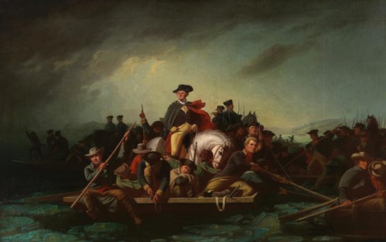
Where Did Washington Cross the Delaware River
On December 25, 1776, General George Washington and a small army of 2400 men crossed the Delaware River at McConkey’s Ferry, in Bucks County, Pennsylvania, on their way to successfully 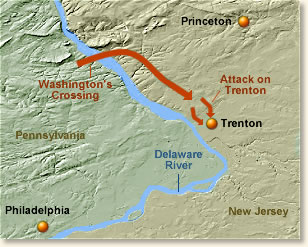 attack a Hessian garrison of 1500 at Trenton, New Jersey.
Washington famously crossed the Delaware River during the American Revolutionary War. The crossing took place near McConkey’s Ferry in Pennsylvania, and it played a pivotal role in the surprise attack on the Hessian forces in Trenton, New Jersey. Washington’s daring move ultimately contributed to a crucial victory for the Continental Army, boosting morale and turning the tide of the war.
Despite how the famous picture or the painting where Washington’s most famous is  portrayed, the Delaware River is very narrow at this location. Durham boats and flat ferries were used to cross. They were probably fixed to a wire strung across the river.
They were probably fixed to a wire strung across the river. The upper Delaware water flows from two branches in the Catskill mountains of New York in the Catskill mountains and eventually flows into Delaware Bay through the center of Philadelphia, truly one of the greatest American rivers. All parts in 3 states were used by the military the Delaware Canal, Jersey Delaware River, Delaware County
The Delaware water into NJ from Pennsylvania until today is less than 300 yards wide I live 10 miles from this spot in Bucks County PA downstream. General George Washington and the Continental Army’s famous crossing of the Delaware River on December 25-26, 1776, was done during a winter Nor’easter with no bridge on this cold night.
By the time most of the soldiers would reach the launching point for the boats, the drizzle had turned into the driving rain. And by 11 o’clock that evening, while the boats were crossing the river, a howling nor’ easter made the miserable crossing even worse.
One soldier recorded that “it blew a perfect hurricane” as snow and sleet lashed Washington’s army. A full 3 hours behind schedule, temperatures for the crossing ranged from 29 degrees to 33 degrees, with brisk winds coming out of the northeast.
George Washington was 44 years old at the time of the Delaware River crossing. Future US President James Monroe crossed river water with the American forces and was wounded at the Battle of Trenton. There were roughly 1,380 Hessian soldiers in and around Trenton at the start of the battle. Because the weather that night was so bad the Hessions feared no attack. They were wrong.
Conclusion
In conclusion, discovering where the Delaware River starts involves an exploration that takes you back to the heart of the New York Catskills. This dynamic river holds a rich history, abundant life, and a vibrant ecosystem within its depths. Our journey has taken us from a tiny spring within this mountain range to its expansive arrival in the Atlantic Ocean at the Delaware Bay. A Delaware River overview has led us on a venture of ecological wonder, and historical importance, and enriched our understanding of this awe-inspiring waterway. This is a river with a story a great historical story.
![]()
References:
Washington Crossing Historical Park-Where did Washington get Durham Boats
History Channel– George Washington crosses the Delaware River
![]()
Jim is a proud member of the Delaware Riverkeeper Network
FAQ’s
- Are there any dams along the Delaware River? Yes, there are several dams along the Delaware River, serving various purposes such as flood control, hydroelectric power generation, and water supply.
- How is the water quality of the Delaware River monitored and maintained? Water quality in the Delaware River is monitored by various agencies and organizations, and conservation efforts are implemented to maintain and improve its overall health.
- What recreational activities are available along the Delaware River? The river offers a range of recreational opportunities, including fishing, boating, hiking, and birdwatching, attracting outdoor enthusiasts.
- Are there any environmental challenges facing the Delaware River? Environmental challenges include pollution, habitat loss, and the impact of climate change. Conservation efforts are underway to address these issues.
- How is the Delaware River managed for water resource sustainability? The Delaware River Basin Commission and other entities work collaboratively to manage water resources sustainably, balancing the needs of various stakeholders and ecosystems.