About 3 million years ago, water draining from the San Juan Mountains of Colorado began carving the river that dissects New Mexico and, eventually, the west and southwest boundary of Texas and the Texas-Mexico border, before emptying into the Gulf of Mexico and this would become The Rio Grande River. Where Does the Rio Grande River Start and End?
The Upper headwaters of the Rio Grande River originate in Colorado high in the San Juan Mountains & the Continental Divide flows south through the San Luis Valley in Colorado, then to Albuquerque & Las Cruces, NM it continues south across the Texan border & ends at the mouth of the Gulf of Mexico.
Probably the first Europeans to see any part of the Rio Grande were those of a Spanish expedition sent out in 1519 to survey the coast of the Gulf of Mexico. Another expedition led by the explorer Francisco Vázquez de Coronado in 1540 to locate rumored rich cities to the north of Mexico resulted in the discovery of various Pueblo Indian communities and explorations in the middle of the Rio Grande and upper Pecos areas.
Introduction:
The Rio Grande, also known as Rio Bravo in Mexico, is one of the most famous rivers in the North American continent. From its source in the Colorado Rocky Mountains to its terminus in the Gulf of Mexico, it traverses a diverse range of landscapes, defining the border between Mexico and the United States. This article unravels the journey of the Rio Grande, focusing on its geographical beginnings and conclusion, exploring the changes in its landscape, and investigating its ecological, cultural, and political significance.
Where Does the Rio Grande River Start and End
The Rio Grande River, also known as the Rio Bravo in certain parts of North America, has a journey as captivating as the science behind its creation. This grand river begins, or rather, has its beginning, nestled within the tranquility of the San Juan Mountains of Colorado’s Southern Rockies. Sculpted over time by water rushing downwards, the Rio Grande brings life to diverse environments and a host of animals as it travels south. Motion, water, and time have all danced in sync to carve out the Rio’s path.
We wouldn’t be exaggerating if we stated that water, specifically the flow of water, forms not only the river’s path but also the bedrock of environmental science. From high in the North, the river starts its journey, its icy waters blended with the melting snow of the San Juan Mountains. Once the river water is unleashed, it begins a remarkable narrative, trickling down slopes, rushing over cliffs, meandering around obstacles, and shaping the landscape as it heads towards its end.
After leaving the Rockies, the Rio Grande gathers more water as it intersects with the Red River. This joint force, a blend of water from different sources, magnifies as it runs steadfastly toward the North. Despite the changing landscapes it traverses, the river holds its course, doesn’t it? The diverse environments it nurtures along its path showcase the sheer determination and resilience of this natural marvel.
The end of the river is as dramatic as its start, with the burst of water coming with the salty brine of the ocean. This melding of freshwater from the mountains in the North and the saltwater of the Gulf symbolizes the river’s end.
So, the Rio Grande’s journey, which begins in the San Juan Mountains and ends in the Gulf of Mexico, is much more than a flow of water from north to south. It involves water, lots of water, but it’s also about the science of geography, the wealth of animals it supports, and the environments it shapes in the Southwest part of the country.
It is the 3rd longest river system in the United States and in the top 20th longest in the world. It reaches peak flow from snowmelt like most mountains in the US and has many problems that have developed over the years. Because of both drought and overuse, the Rio Grande is considered threatened by Climate Change like most rivers in the southwestern United States.
Uncovering the Journey of the Rio Grande River
Known by several names, the Rio Grande (or as some refer to it, Rio Bravo), is much more than just a river, it’s a silent storyteller, narrating tales about the lands it crosses and the cultures it unites. The journey of this big river stretching miles and miles across North America is indeed an intriguing narrative that deserves a detailed explanation.
The Rio Grande is one of the longest rivers in North America, flowing from the Rocky Mountains of Colorado through New Mexico, along the border between Texas and Mexico, and finally emptying into the Gulf of Mexico. The journey of the Rio Grande is rich in geographical, ecological, and cultural significance.
- Headwaters in Colorado: The river begins its journey in the San Juan Mountains of Colorado. The melting snow from these mountains feeds into the Rio Grande, providing the initial flow for the river.
- Flow through New Mexico: As the Rio Grande moves southward, it traverses the diverse landscapes of New Mexico. The river plays a crucial role in sustaining ecosystems and providing water for agriculture in this region.
- International Border with Mexico: The Rio Grande serves as a natural border between the United States and Mexico for a significant stretch. The river’s flow is managed by various agreements and treaties between the two countries.
- Challenges of Water Management: The Rio Grande faces challenges related to water scarcity and allocation, especially in the arid regions of the southwestern United States. Upstream water use, agriculture, and urban demands often strain the river’s resources.
- Ecological Importance: The river and its surrounding riparian habitats support a diverse array of plant and animal species. Many migratory birds depend on the Rio Grande for their journey.
- Cultural Significance: The Rio Grande has been a lifeline for indigenous communities and later settlers. Native American tribes historically relied on the river for sustenance, and its waters played a vital role in shaping the development of communities along its banks.
- Rio Grande Valley: The lower reaches of the river pass through the Rio Grande Valley, an area known for its agricultural productivity. The river irrigates fields, supporting the growth of crops like cotton, pecans, and citrus fruits.
- Challenges and Conservation: Human activities, including water withdrawals, pollution, and alterations to the river’s course, pose challenges to the Rio Grande’s health. Conservation efforts are underway to protect the river’s ecosystems and ensure its sustainable use.
- Impact of Climate Change: Like many rivers, the Rio Grande is affected by climate change, leading to altered precipitation patterns, increased temperatures, and potential impacts on water availability.
Understanding the journey of the Rio Grande involves considering its geographical features, ecological role, cultural significance, and the ongoing efforts to manage and preserve its resources.
The Rio Grande River, one of North America’s most fascinating natural wonders, embarks on its extensive journey from the snow-capped mountains in the north. Its crystal clear water, originating from the chilly terrains of Colorado, meanders through New Mexico and flows unimpededly south to Texas. This stretch across different states makes the river an emblem of geographical diversity.
Throughout its course, the Rio passes by numerous settlements and cities. Its water becomes the life source for flora and fauna along its banks, contributing to the ecological prosperity of the regions it graces. Even though you’d think that a river’s journey is primarily about a water body flowing aimlessly between lands, the Rio Grande River’s course is much more purposeful.
It doesn’t just carry water; it transports life, culture, and history for miles and miles. The Rio has been a silent witness to societal evolution, economic development, and transformations over time.
As the river heads further south into Texas, the Rio Grande’s journey the river broadens, the flow intensifies, and the surrounding landscapes take a drastic turn. At this point, the water, initially crystal blue, now turns into a deeper shade, implying the change in topography beneath.
It evolves from being a bubbling brook flowing from its headwaters through mountainous terrain to a calm, placid river flowing across plains. Despite its tranquility, the Rio Grande never ceases to impress with its persistence and timeless journey. It flows over 1,900 miles. Amazingly, every time you think it has reached its end, another stretch of the big river emerges.
Uncovering the journey of the Rio Grande River isn’t just about determining the river’s start or end, but understanding how the water shapes nurturing habitats and unique ecosystems along its path. It’s about realizing the importance of every drop of water, each mile it flows, and how it impacts the communities living around it. Finally, the Rio Grande’s journey to the Gulf of Mexico ends, yet the river’s influence lives on, nurtured by the many miles it has traveled, forever ingrained in the heart of Texas.
Diving Deep into Colorado’s Relation with Rio Grande
Colorado has a crucial role in the Rio Grande’s journey as it houses the river’s headwaters in the San Juan Mountains. The melting snow from these mountains feeds into the Rio Grande, initiating its flow and influencing its water availability downstream. The state’s management of water resources and environmental policies significantly impact the health and sustainability of the Rio Grande as it continues its course through New Mexico and beyond

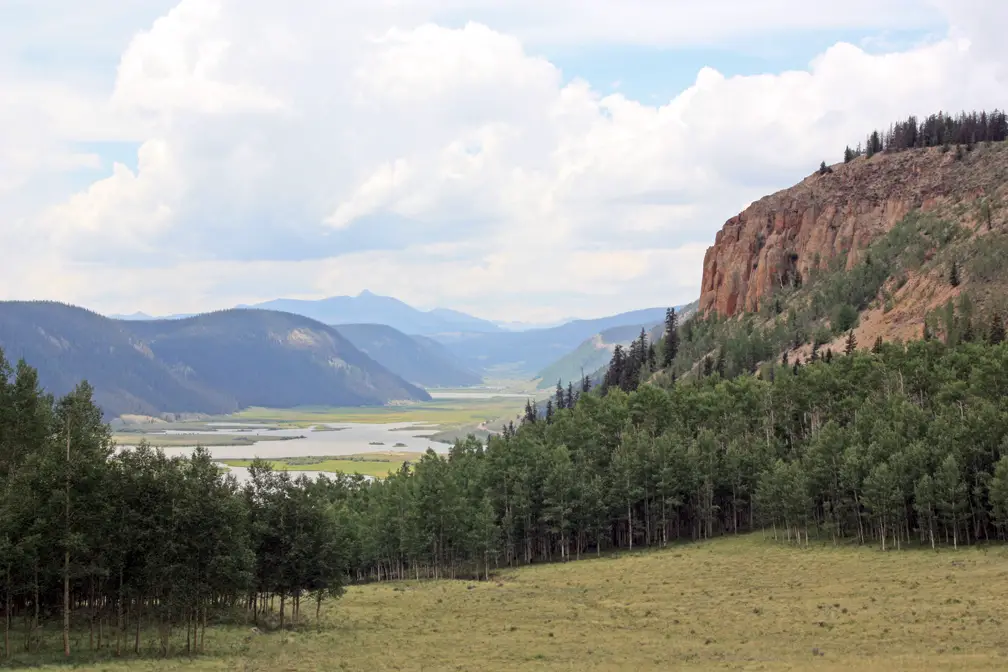
The journey of this remarkable river commences in the San Juan Mountains in Colorado’s Southern Rockies. This area, known as the “upper Rio,” is the heart of Colorado’s ties to the Rio Grande. From these high mountain ranges, the river begins its journey north, setting the stage for its essential place within the United States and its rivers.
The Rio Grande Basin lies in Colorado and is responsible for fostering the Rio Grande River’s primary source, collecting the water volume that rushes down from the snow-capped peaks. This “upper Rio” region is notable for its majestic Grande Gorge, making it a vital part of Colorado’s landscape.
The water from this river not only shapes Colorado’s geography but also sustains the region’s biodiversity. An exploration of Colorado’s intertwining “relationship” with the Rio further confirms its relevance.
The Rio Grande winds through Colorado, creating a life-blood connection that’s hard to overlook. As the river flows, it curves and carves through the rugged terrain, forming the stunning Grande Gorge.
The magnitude of the gorge is a testament to the power of this water source and highlights how the river has helped shape the physical landscape over the years. Moreover, the river’s contribution to the overall water supply in the region is invaluable, making it one of the central rivers of the United States.
It isn’t just Colorado’s terrain that has a deep relationship with the river, but also its residents. Colorado’s population relies heavily on the water supply from the Rio Grande, especially those inhabiting the Northern parts. This bond between people and the Rio Grande transcends physical reliance, echoing the unbreakable bonds between Colorado and its rivers.
In sum, diving deep into Colorado’s relationship with the Rio Grande reveals a mutual dependency. This relationship isn’t merely geographical but spans ecosystems and human lifelines, underscoring the integral role the river plays in the United States, particularly the North.
Indeed, the journey of the Rio Grande from its birthplace in the Colorado Rockies to its culmination point underlines the importance of this river’s relationship to its homeland.
The Grande Basin lies in Colorado and is responsible for fostering the Rio Grande River’s primary source, collecting the water volume that rushes down from the snow-capped peaks. This “upper Rio” region is notable for its majestic Grande Gorge, making it a vital part of Colorado’s landscape. The water from this river not only shapes Colorado’s geography but also sustains the region’s biodiversity. An exploration of Colorado’s intertwining “relationship” with the Rio further confirms its relevance.
A notable aspect of the Rio Grande’s management and utilization is the presence of dams along its course, which contribute to water resource management, agriculture, and electricity generation.
The river is harnessed by electric dams, contributing to power generation and water resource management in the regions it serves. Its significance extends beyond state boundaries, supporting communities and industries.
Exploring Colorado’s Rivers and Their Role in Feeding the Rio Grande River
As we continue exploring the journey of the beloved Rio Grande, it’s essential to take a look at Colorado’s rivers and their crucial role in feeding this big river. In the heart of the United States, particularly in Colorado’s southern Rockies, lie the San Juan Mountains from where the Rio Grande River begins its grand journey.
This area, known as the Upper Rio Grande Basin, garners the eagerly awaited water from the melting snow of the mountains, gradually feeding it into the main waterway. Interestingly, this upper Rio holds quite an important role, not only for the Grande Basin but also for other parts of the United States.
The water from Colorado’s rivers is like the lifeblood of the Rio Grande. For instance, the snow melts streaming down the upper Rio create a productive ecosystem, where diverse river species can thrive. This natural process allows the Rio to live up to its name, with ‘Rio Grande’ translating to ‘Big River’ in Spanish, making it one of the vital water sources running through the United States.
It’s intriguing to notice that every river in Colorado plays its part in making the Rio Grande what it is today. Each of these rivers, with its unique quirks and traits, pours its waters into the Rio, giving it the strength to continue its journey. From the fresh clear waters flowing down from the San Juan Mountains of Colorado’s southern Rockies to the tumultuous waters of the upper Rio, each contributes to the grand spectacle that we see today.
- San Juan River: Originating in the San Juan Mountains of Colorado, the San Juan River is a major tributary that contributes to the headwaters of the Rio Grande. Its melting snow and runoff play a crucial role in initiating the flow of the Rio Grande.
- Rio Chama: Flowing through both Colorado and New Mexico, the Rio Chama is another significant tributary of the Rio Grande. Its waters augment the Rio Grande’s volume, particularly during the early stages of its journey.
- Conejos River: The Conejos River, located in southern Colorado, is a tributary that joins the Rio Grande in the San Luis Valley. It adds to the overall water supply of the Rio Grande, supporting the river’s flow through different regions.
- Los Pinos River: Also known as the Pine River, the Los Pinos River flows through southwestern Colorado. Its contributions to the Rio Grande’s water supply are part of the intricate network of rivers that sustain the main stem of the Rio Grande.
- Alamosa River: Originating in the San Juan Mountains, the Alamosa River is another tributary that merges with the Rio Grande in the San Luis Valley. Its waters contribute to the overall health and flow of the Rio Grande.
- Culebra Creek: Flowing through the San Luis Valley, Culebra Creek is a smaller but significant watercourse that feeds into the Rio Grande. The combined contributions of these various rivers and tributaries highlight Colorado’s role in nourishing the Rio Grande throughout its course.
Along its meandering path, it creates diverse environments that host a myriad of species, some of which are found nowhere else on Earth. Additionally, numerous tributaries feed into the Rio Grande, contributing to the river’s flow and the ecosystems it supports.
However, among all rivers, the Rio Grande River is the big-ticket water feature for many, nurturing the land and the communities it passes through as it continues to flow diligently, making its way to the Gulf of Mexico.
Exploring the journey of the Rio Grande just about admiring its beauty; it’s also about understanding the interconnectedness of all elements of nature. Indeed, this mighty river, the Rio Grande, isn’t just a stand-alone feature, but a culmination of countless rivers making their way through one of the world’s most impressive landscapes, creating a symbiotic relationship that plays an essential role in feeding and sustaining life, especially through this arid Southwest part of the US.
Understanding the Rio Grande as a Border
When it comes to understanding the Rio Grande as a border, it’s crucial to know how this river became a division notch. The Rio Grande River has been a natural border between the United States and Mexico since the signing of a treaty.
Its history is rich and as deep as the river itself a marker that has divided Texas from its southern neighbor five times over. The lower Rio has been argued over, fought for, and managed. To this day, Texans take great pride in their shared border with Mexico.
Beginning in Colorado, in the United States, the Rio Grande River makes a staggering journey before it eventually ends in the Gulf of Mexico. The management of the Rio Grande, especially the lower Rio areas, is necessary for maintaining an ecological balance.
Colorado a state blessed with rivers that contribute to the Rio Grande takes a great interest in this management. Texas, on the other hand, focuses more on the Rio Grande as a border, a divider between two familiar yet different cultures. It’s therefore fundamental to get an understanding of the Rio Grande from multiple perspectives.
Understanding Rio Grande doesn’t only involve recognizing it as a river or a border; it’s about appreciating its diverse roles across different states. A river within the United States, a border with Mexico, and an essential asset for Colorado and Texas, the Rio Grande River is multifaceted. To say that Texas relates to the Rio Grande differently than Colorado would be an understatement. For each state, the Rio Grande River, or Rio as they lovingly call it, signifies a unique aspect.
The Rio Grande serves as a natural border between the United States and Mexico for a substantial stretch of its course, shaping the political, social, and economic dynamics of the region. This border has several key aspects:
- Geographical Boundary: The river creates a geographical boundary, with the United States to the north and Mexico to the south. This physical feature has influenced settlement patterns, access to water resources, and the development of communities along its banks.
- International Agreements: The management of the Rio Grande as a border involves international agreements and treaties between the United States and Mexico. These agreements address water usage, environmental conservation, and the resolution of disputes related to the shared resources of the river.
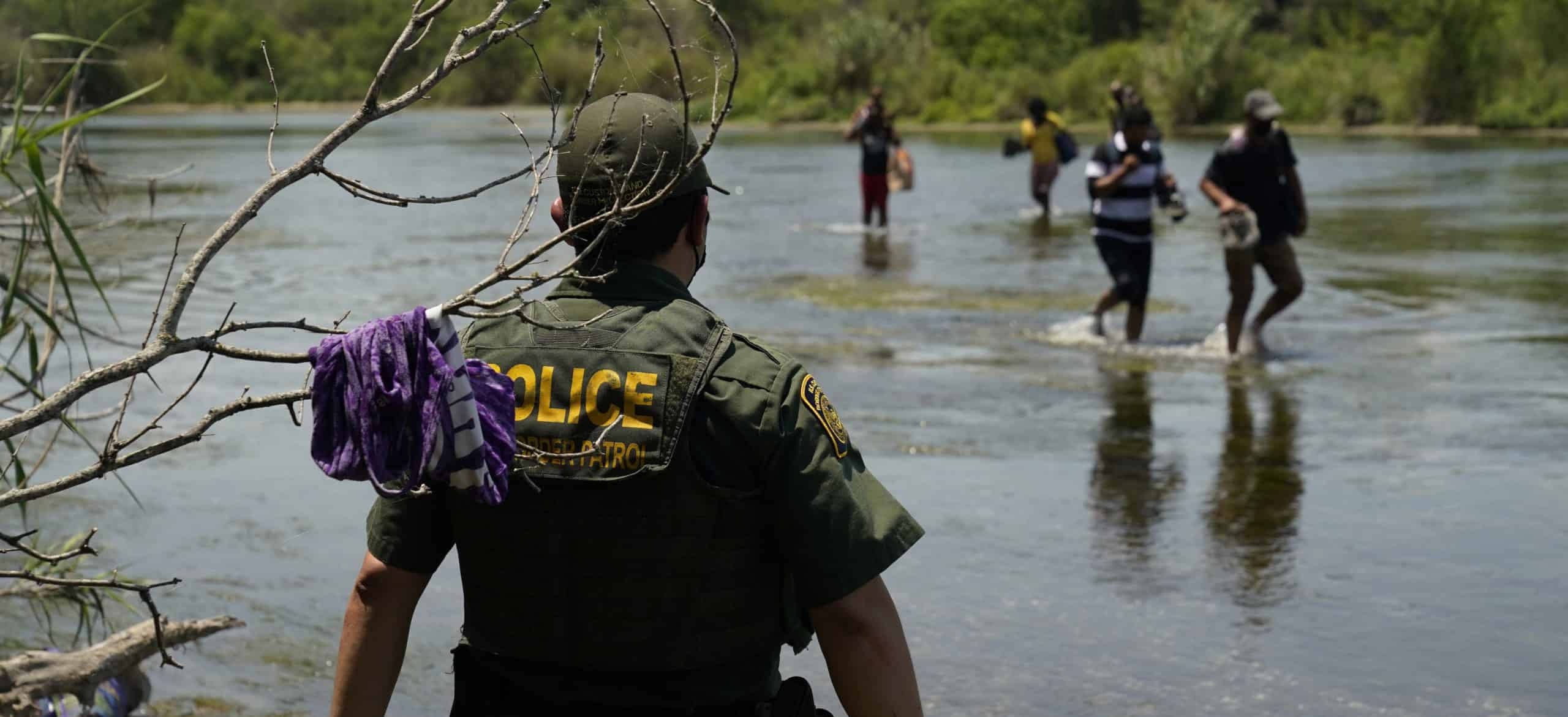
- Challenges of Border Security: The Rio Grande has presented challenges and complexities in terms of border security. Its meandering course and variable water levels have been factors in discussions and efforts to manage and secure the border region.
- Cross-Border Communities: Some cities and towns are situated directly along the Rio Grande, creating unique cross-border communities where people on both sides of the river share cultural, familial, and economic ties. This interdependence is evident in areas such as El Paso-Ciudad Juárez and Laredo-Nuevo Laredo.
- Environmental Impact: The border region’s ecosystems are interconnected, and the management of the Rio Grande as a border involves considerations of environmental impact. Changes in water flow, pollution, and alterations to the river’s course can affect both sides of the border.
- Water Allocation Disputes: The allocation of water from the Rio Grande has been a source of disputes between the United States and Mexico, as well as among U.S. states along the river. Balancing the needs of agriculture, urban areas, and the environment requires ongoing negotiation and cooperation.
- Cultural Significance: The Rio Grande holds cultural significance for both nations, with indigenous communities historically relying on its waters. The river has been a symbol of connection and division, influencing the cultural identity of those living in the border region.
Understanding the Rio Grande as a border involves considering its role in shaping geopolitical relationships, fostering cooperation and challenges between nations, and impacting the lives of people on both sides of the boundary.
The history of the Rio Grande as a division line is as turbulent as the river itself. Treaties have been penned and scrubbed, shifting the river’s border status over time. Texas, with its hard-earned history, has seen the Rio Grande transform from a source of discord to a symbol of unity.
The history of the Rio Grande highlights its role in shaping the United States and Mexico’s political landscape. And in doing so, the Rio Grande River has become more than just a water body – it’s a silent witness to change, a testament to unity and division, an ever-present borderline.
Examining the Rio Grande’s Role as the Border Between the United States and Mexico
If you’re looking for a one-day read, dig into the fascinating tale of the Rio Grande River, or Rio Bravo as it’s known in Mexico. As one of the longest rivers in North America, starting in Colorado, flowing through New Mexico, and into Texas, before it ends its journey at the Gulf of Mexico, the Rio Grande plays an indispensable role as a natural border between the United States and Mexico. With each passing day, its significance becomes increasingly prominent.

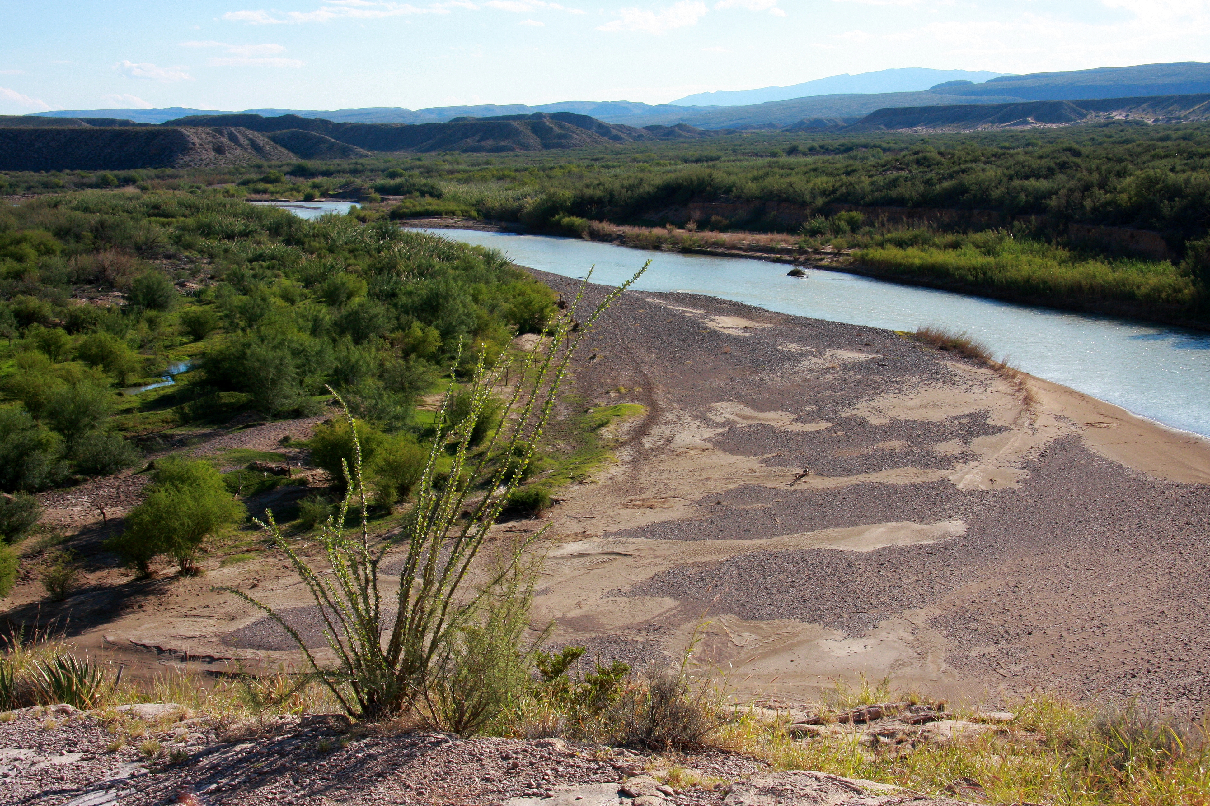
The River earns its nickname, ‘Rio Bravo,’ or ‘wild river,’ from the lower, wild sections that challenge even experienced adventurers. This might surprise some who only know the Rio Grande as a dried-up riverbed in Texas, but it also demonstrates the River’s complex and shifting nature. The Rio Grande’s role as a border has never been straightforward, in part because the River is always changing.
United States’ relation with the Rio Grande is one of the mutually benefiting elements that the Treaty of Guadalupe Hidalgo, signed in 1848, ensured. Within the United States, the Rio Grande River is primarily known for its importance to the state of Texas. Though not always a clear or continuous line, the River has remained the definitive political boundary between the United States and Mexico.
Texas claimed its border with Mexico was the Rio Grande, while Mexico claimed its border with Texas was at the Nueces River. This dispute over the Texas-Mexico border caused more problems when the U.S. annexed Texas in 1845.
It was then that the U.S. declared war against Mexico a year later, which started the Mexican-American War.
The border between the United States and Mexico stretches for nearly 2,000 miles from the Gulf of Mexico to the Pacific Ocean and touches the states of California, Arizona, New Mexico, and Texas. After a series of bloody battles and sieges, American forces captured the Mexican capital in September 1847.
The Rio Grande runs along 1,254 miles of the border, but west of El Paso, Texas, the boundary lacks a natural geographic barrier except for a small stretch along the Colorado River.
This being said, it’s not just a border. The Rio Grande is also a lifeline in the arid landscapes of the southern United States and northern Mexico, providing precious water resources for agriculture, industry, and cities. Furthermore, it’s home to a diverse range of species, some found nowhere else on earth, and forms a critical part of two National Parks.
The Rio Grande serves as a natural border between the United States and Mexico for a substantial stretch of its course, shaping the political, social, and economic dynamics of the region. This border has several key aspects:
- Geographical Boundary: The river creates a geographical boundary, with the United States to the north and Mexico to the south. This physical feature has influenced settlement patterns, access to water resources, and the development of communities along its banks.
- International Agreements: The management of the Rio Grande as a border involves international agreements and treaties between the United States and Mexico. These agreements address water usage, environmental conservation, and the resolution of disputes related to the shared resources of the river.
- Challenges of Border Security: The Rio Grande has presented challenges and complexities in terms of border security. Its meandering course and variable water levels have been factors in discussions and efforts to manage and secure the border region.
- Cross-Border Communities: Some cities and towns are situated directly along the Rio Grande, creating unique cross-border communities where people on both sides of the river share cultural, familial, and economic ties. This interdependence is evident in areas such as El Paso-Ciudad Juárez and Laredo-Nuevo Laredo.
- Environmental Impact: The border region’s ecosystems are interconnected, and the management of the Rio Grande as a border involves considerations of environmental impact. Changes in water flow, pollution, and alterations to the river’s course can affect both sides of the border.
- Water Allocation Disputes: The allocation of water from the Rio Grande has been a source of disputes between the United States and Mexico, as well as among U.S. states along the river. Balancing the needs of agriculture, urban areas, and the environment requires ongoing negotiation and cooperation.
- Cultural Significance: The Rio Grande holds cultural significance for both nations, with indigenous communities historically relying on its waters. The river has been a symbol of connection and division, influencing the cultural identity of those living in the border region.
Understanding the Rio Grande as a border involves considering its role in shaping geopolitical relationships, fostering cooperation and challenges between nations, and impacting the lives of people on both sides of the boundary.
While examining the National and historical aspects, it becomes evident that the River’s role is more intricate and multifaceted. The Rio Grande’s importance extends far beyond Texas, affecting all border states in the United States and Mexico. One day spent examining the Rio Grande’s role as a border might not seem like enough time.
However, it’s a journey worth taking on regardless. Whether you’re already planning a vacation to one of the River’s many National Parks or just curious about one of North America’s most dynamic natural features, understanding the Rio Grande is an enlightening endeavor for any and all.”
In Colorado, the river plays a pivotal role, starting its journey in the San Juan Mountains, a breathtaking and picturesque region of the state. The Rio Grande is not just a geographical feature in Colorado; it significantly influences the state’s water supply, which is critical for sustaining its population and agriculture.
In Texas, a state known for its arid climate, the Rio Grande River takes on even greater importance. It serves as a lifeline, providing essential water resources to a region where water scarcity is a constant concern. As it flows through various Texan cities, it becomes a defining element of the state’s geography and plays a central role in supporting urban and agricultural needs. Its ultimate destination is the Gulf of Mexico, where its waters mingle with the ocean, impacting the marine ecosystem.
Rio Grande River Facts
Here are some key facts about the Rio Grande River:
- Length: The Rio Grande is one of the longest rivers in North America, with a length of approximately 1,900 miles (3,060 kilometers).
- Source: The river originates in the San Juan Mountains of Colorado and flows through New Mexico, along the Texas-Mexico border, and into the Gulf of Mexico.
- International Border: A significant portion of the Rio Grande serves as a natural border between the United States and Mexico. This section of the border is approximately 1,255 miles (2,018 kilometers) long.
- Tributaries: The Rio Grande is fed by numerous tributaries, including the Rio Conchos, Pecos River, Rio Chama, and others. These tributaries contribute to the river’s flow and play a vital role in its ecosystem.
- Water Flow: The river’s flow varies seasonally, with increased water levels during the spring and early summer due to snowmelt from the Rocky Mountains.
- Ecological Diversity: The Rio Grande and its surrounding areas are home to diverse ecosystems, supporting a variety of plant and animal species. The river provides critical habitat for migratory birds and serves as a lifeline for many wildlife species.
- Human History: Indigenous communities have inhabited the Rio Grande region for thousands of years. The river played a significant role in the development of ancient cultures, including the Puebloan peoples.
- Major Cities: Several major cities are located along the Rio Grande, including Albuquerque and Santa Fe in New Mexico, El Paso in Texas, and Ciudad Juárez in Mexico.
- Water Management Challenges: The Rio Grande faces challenges related to water management, including over-extraction for agricultural and urban use, leading to disputes over water rights among states and countries along its course.
- Cultural Significance: The Rio Grande has cultural importance for various communities, influencing traditions, folklore, and the identity of those living in the river basin.
- Rafting and Recreation: Certain sections of the Rio Grande offer opportunities for recreational activities, including rafting and kayaking. The river’s canyons and scenic landscapes attract outdoor enthusiasts.
- Conservation Efforts: Efforts are underway to address environmental concerns and ensure the sustainable use of the Rio Grande’s resources, including conservation projects and initiatives to protect the river’s ecosystems.
These facts provide a glimpse into the geographical, cultural, and environmental significance of one of the longest and historical rivers in North America the Rio Grande River.
Conclusion:
In summary, the Rio Grande River is a significant and historic body of water commencing its journey in Colorado’s Canby Mountain, ultimately ending its course into the arms of the Gulf of Mexico. Its path touches the diverse landscapes of New Mexico and Texas, providing essential sustenance to flora, fauna, and human populations. The journey of the Rio Grande showcases the remarkable vitality and resilience of nature, embodying an inspiring testament to the interconnectedness of geographic and life processes. Through each step of its trek, the Rio Grande underlines its indispensable role in the ecology and culture of the regions it travels through.
Will California Run Out of Water?
Yes, California will run out of water within 1 year, says, Jay Famiglietti, a NASA senior Water Scientist at the Jet Propulsion Laboratory. Data reveals that total H2O storage in Ca. has been declining since 2002 when satellite-based monitoring began, & groundwater depleting since the early 20th century..……………………………………………….read more

References: International Boundary and Water Commission
National Archives– Treaty of Guadalupe Hidalgo (1848)
FAQ’s
Q: Why is the Rio Grande River significant to the United States and Mexico?
A: The Rio Grande River is significant not only because it acts as a natural border between the United States and Mexico, but also because it provides crucial water resources for agriculture, industry, and cities in the arid landscapes of the Southern United States and Northern Mexico. It also supports a diverse range of species, some found nowhere else on Earth.
Q: How does the Rio Grande River impact Colorado specifically?
A: The Rio Grande River is a critical part of Colorado’s landscape. It starts in the San Juan Mountains, one of the most picturesque places in the state, and it shapes the physical landscape over time. The population of Colorado also relies heavily on the water supply from the Rio Grande.
Q: How does the Rio Grande River play a role in Texas?
A: In Texas, the Rio Grande River is vital for the state’s water supply; the state is otherwise quite arid. The river carves its path along the contours of the land, bringing invaluable water to the state. The river flows through several cities, making it a significant part of the state’s geography and feeding into the Gulf of Mexico.
Q: What is the Rio Grande River’s ecological significance?
A: The Rio Grande River plays a crucial role in supporting the ecosystem along its path. As it flows, it creates diverse environments that host a variety of species. Moreover, the water from the river eventually mingles with the salty ocean water, thereby playing a significant role in the ocean’s ecosystem.