
Numerous Native American peoples inhabited the Columbia River basin for several thousand years. Spanish explorers sailing up the Pacific coast in about 1775 probably were the first Europeans to sight the river’s mouth including early explorations in 1792 by Captain Robert Gray, a Boston trader who named the 7th largest river in North America after his boat. Where is the Columbia River located?
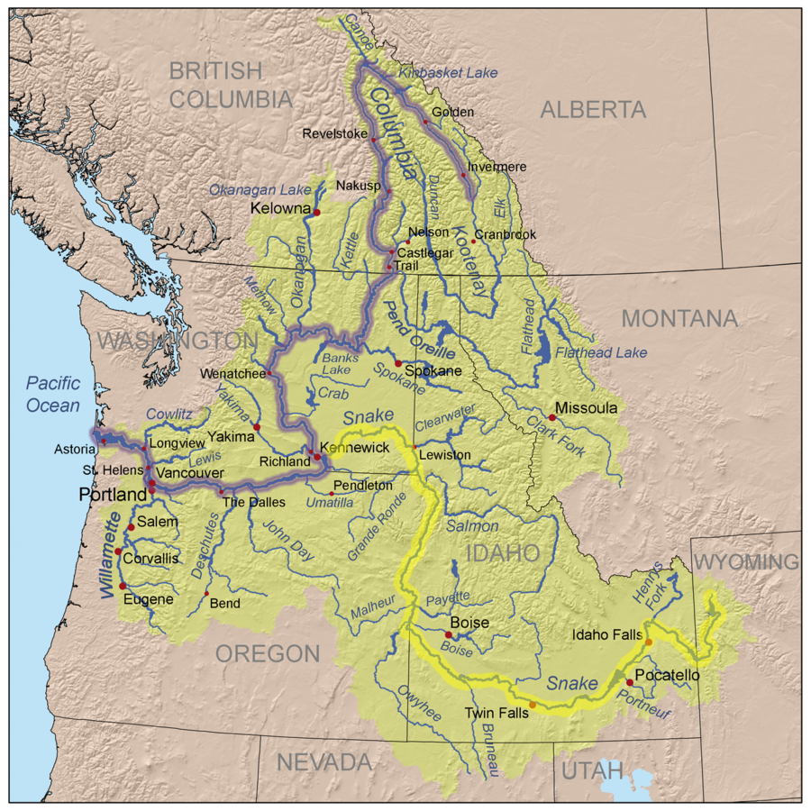
The Columbia River is located in the Pacific Northwest region of North America rising in the Rocky Mountains of British Columbia, Canada into Washington State & Oregon before emptying into the Pacific Ocean at Astoria, Oregon. Its drainage basin extends into 7 US states & 1 Canadian province.
Since the early 20th century, dams have been built across the river for generating power, navigation, irrigation, and flood control. The 14 hydroelectric dams on Columbia’s main stem and many more on its tributaries produce more than 44 percent of total U.S. hydroelectric generation.
Introduction:
The Columbia River, one of North America’s major rivers, holds interesting histories, diverse ecosystems, and significant economic importance. Its journey begins from the Rocky Mountains of British Columbia, Canada, traveling through the US states of Washington and Oregon before emptying into the Pacific Ocean. The focus of this article is to explore the Columbia River’s geographical positioning, alongside imparting useful information regarding its attributes and contribution toward the regions it flows through.
Where Does the Columbia River Start and Stop
The Columbia River, one of North America’s major rivers, holds interesting histories, diverse ecosystems, and significant economic importance. Its journey begins from the Rocky Mountains of British Columbia, Canada, traveling through the US states of Washington and Oregon before emptying into the Pacific Ocean. Our focus is to explore the Columbia River’s geographical positioning, alongside imparting useful information regarding its attributes and contribution toward the regions it flows through.
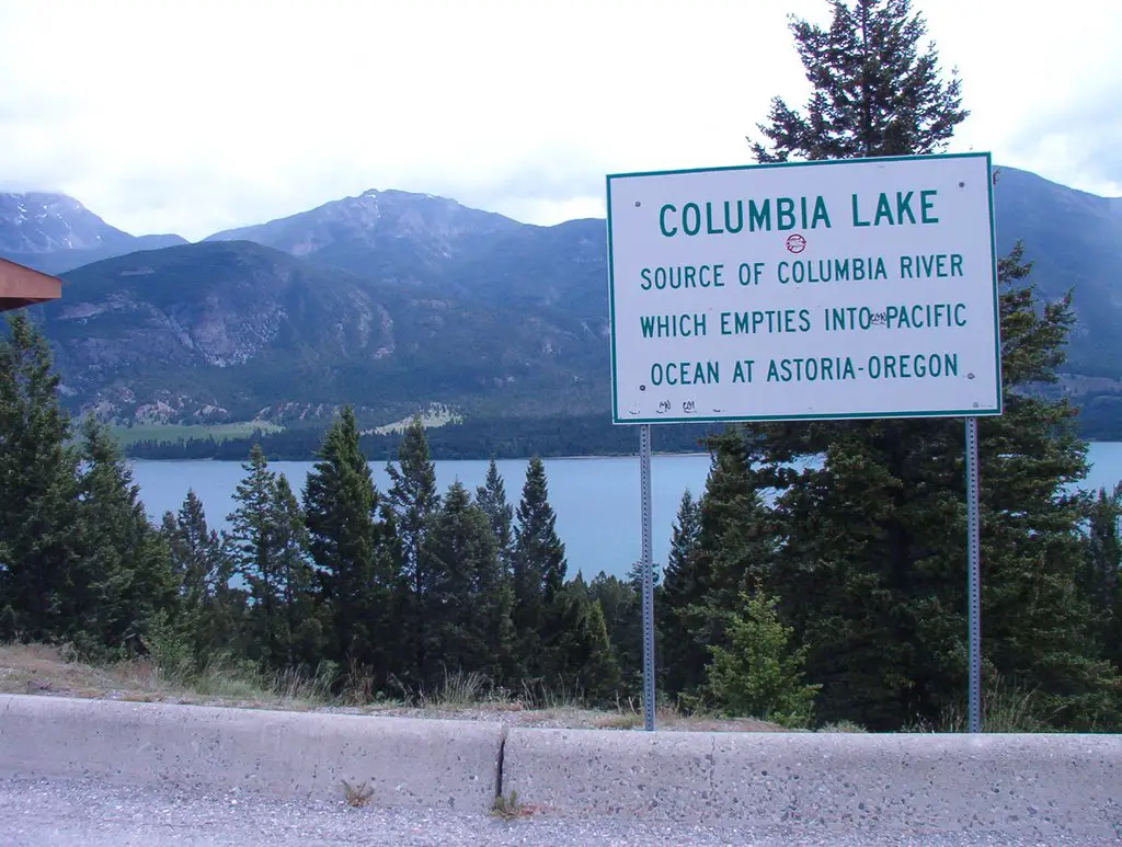 The Columbia River is the largest river that flows in the Pacific Ocean from North America and South America. The headwaters begin between Columbia Lake in the Rocky Mountain Trench and the Selkirk Mountains, of southeastern British Columbia at about 2,656 feet above sea level.
The river flows north for some 200 miles (322 kilometers). Then it turns south and flows for about 270 miles (434 kilometers) before moving through the border of northeastern Washington at River Mile 749, which is 749 miles inland from the Pacific Ocean. This area of the river is called the Big Bend.
Because of its unique situation close to the ocean and laced with tall mountain ranges, Columbia evolved as one of the great rivers of the world in terms of its runoff and the diversity of its habitat. From its headwaters to its mouth, the river drops steadily at a rate of about two feet per mile emptying into the Pacific Ocean at Astoria, Oregon.
The Columbia River Basin covers 258,000 square miles west of the Continental Divide which includes parts of seven U.S. states and one Canadian province. It’s a more than 1,200-mile course that ends in the Pacific Ocean.
The Columbia River flows through four mountain ranges and drains more water to the Pacific Ocean than any other river in North or South America. The Columbia once produced the largest salmon runs on earth, with returns often exceeding 30 million salmon per year. Today, unfortunately only a fraction return to spawning in the river.
Columbia River: From Origins to the Canadian Encyclopedia
The Columbia River one of North America’s most majestic and influential waterways, flows through parts of seven states in the USA and one Canadian province. The river’s origins can be traced to Columbia Lake in the Rocky Mountains, and it’s indeed a sight to behold, with its swift current etching a path through the rugged landscape. The river’s history, ecology, and role in shaping the American and Canadian West were chronicled in the Canadian Encyclopedia.
At Columbia Lake, the river bursts forth in power, marking the beginning of a long journey that ends in the Pacific Ocean. The river does not just serve as a natural boundary but as a critical water source, supporting agriculture, industries, and cities along its course. It’s a shared heritage between the American and Canadian people, tangible evidence of our shared history and intertwined fate.
The Columbia River was first discovered by Robert Gray, an American captain, but it wouldn’t be until Lewis and Clark’s expedition that the river would become a significant gateway to the Pacific. Located strategically, the river played a big role in the fur trade era, with Fort Vancouver serving as a major Hudson Bay Company post.
The Columbia River has been harnessed extensively through a series of dams, providing a crucial source of hydroelectric power. These dams drastically altered the river’s natural flow but also played a vital role in the industrialization of the Pacific Northwest. Consequently, the river’s health has suffered, sparking significant conservation efforts.
The water of the Columbia River continues to shape the lives of those living in its basin, just as it shaped the lives of the original inhabitants of the land and those who came after them. A river of history, of life, and of hope, it is an indispensable part of the American and Canadian narratives.
The Columbia River from its origins at Columbia Lake in the Rocky to its entry into the Pacific Ocean, tells a compelling and complex story. It’s a story of human ambition and progress, of respect for nature and efforts to harness it, of a shared past and a shared future. It’s a story that deserves a place in any Canadian Encyclopedia or any factual record of our continent.
Indeed, the Columbia River is more than just a river. It is a testament to the resiliency of nature and of the people who have depended on it for centuries. It continues to flow, inspiring awe and respect, sustaining life, and reminding us of our past as it carries us into the future.
American Rivers Guide: Columbia River Gorge and its Wonders
Located within the heart of the Pacific Northwest, the formidable Columbia River has carved a majestic river gorge known as the Columbia River Gorge. This river gorge is American Rivers’ finest treasure, a shimmering gem of beauty with wonders waiting to be discovered and savored. Stretching over a significant river mile through Washington and into Portland, the beauty of the Columbia River Gorge goes unrivaled.
From a distance, the Columbia River Gorge might seem just like any other river gorge. But, take a closer look and you’re immersed in a world of American memory, teeming with a rich history that spans centuries. The textures and hues of the Columbia River Gorge tell tales of native tribes, explorers, and the growth of Portland as we see it today, echoing snippets of long-gone eras, leaving one marveling at their natural wonder.
But there’s more to this Pacific Northwest gem than meets the eye. Every twist and turn of the Columbia River and the river gorge unfolds a unique portrait- from lush forests and towering cliffs to the rare sight of a volcanic field, secreted beautifully within its confines. This volcanic field, still active, is a testament to the dynamic geology that birthed the Columbia River and its gorge, a sight that beckons every water lover.
Presenting an offer too irresistible for water enthusiasts and nature lovers, the Columbia River twist and turns meeting with the Columbia Slough, (The Columbia Slough is a narrow waterway, about 19 miles (31 km) long, in the floodplain of the Columbia River in the U.S. state of Oregon) that paves the way for countless recreational activities. It’s the ideal backdrop for a fun-filled day in the water or a quiet, reflective moment soaking in the serenity of the surroundings.
Situated on the Washington side is the flourishing city of Vancouver, home to the voluminous Columbia River. It’s no surprise that the Columbia River, the Columbia Slough, and the river gorge have become integral parts of Vancouver’s identity, rendering it a must-visit when in Washington. Rediscovering the splendor of the Columbia River shouldn’t end here. Head over to Portland, conveniently situated less than a hundred miles away, and take in the panoramic views that leave you entranced.
Water, the heart of an ecosystem, is one of the most captivating features of the Columbia River, the Columbia River Gorge, and their surrounding cities. Especially since, the Pacific Northwest with Portland and Vancouver, is bathed in beautiful waterscapes. Let the water of the Columbia River mesmerize you with its sheer power and beauty and feel its ebbing waves trance you into a state of awe.
Length and Mysteries of the Columbia River from the Archives
The Columbia River is undeniably a marvel of nature, particularly noted for its overwhelming length and the mysteries associated with it. The Columbia River stretches over a stunning expanse, carrying its life-giving waters from its mount high up in the rugged landscapes of the Canadian Rockies all the way down to where it meets with the Pacific Ocean in Washington.
The journey that the Columbia River embarks on is not one for the faint-hearted, though. This powerful river not only winds through deep, mysterious valleys but also powers numerous dams, contributing significantly to the energy conservation efforts of the regions surrounding it.
However, there’s much more to the Columbia River than just its length and the dams it powers. Indeed, the pages of history, hidden in the archives, reveal many more fascinating, albeit complex aspects of the Columbia River. Perhaps no fact highlights the uniqueness of the Columbia River better than its intricate relationships with the various tribes that have lived along its course since time immemorial. From these tribes, we discover interesting insights about the Columbia River from the American perspective, further deepening the river’s captivating allure.
What’s more, the archives shed light on how the Columbia River has been a significant contributor to the development of the American Northwest, chiefly among which are the numerous economic activities that have flourished along its banks throughout the centuries. These activities range from agriculture and fishing to trade and transportation, once again accentuating the indispensable role that this singular water body plays in sustaining life and promoting prosperity.
You can’t talk about the Columbia River without mentioning the impact that it continues to have on Washington State. In Washington, the Columbia River is more than just a water source; it’s a lifeline and a symbol of pride. It’s so interconnected with the life of the Washington residents that it’s virtually impossible to separate the two. Even today, one can easily see how deeply ingrained the Columbia River is in Washington’s everyday lifestyle be it in the state’s economy, its ecology, or its culture the Columbia River is everywhere you look.
No discussion about the Columbia River would be complete without addressing the diverse ecosystem it fosters. The water of the Columbia River hosts an array of plants and animals, both in its depths and on its banks.
Whether it’s the lively aquatic community beneath the river’s surface, the American wildlife that calls the river’s margins home, or the vibrant avian species that grace the river’s sky, the Columbia River is a beacon of biodiversity, bringing life to its truest form to Washington State and beyond.
In conclusion, the Columbia River, with its sprawling length, dazzling depth, intricate relationships with tribes, and vital contributions to Washington’s history, stands as a testament to the power and beauty of nature itself. And in every mystery that this awe-inspiring river veils, from its ancient archives to its current contributions, there lies an opportunity to understand and honor the remarkable intertwining of nature and mankind.
Deciphering the Columbia River Map Found in the Canadian Encyclopedia
The Columbia River map is a fascinating illustration mapping out the Pacific River’s journey, flowing from its source in the Columbia River through to the mighty Pacific Ocean.
When checking out a map of the Columbia River for an enlarged view, several aspects become apparent that aren’t as clear in the original, smaller image. These features come to life, showing off this significant river, the Columbia River, in all its glory.
The Columbia River has its start in Columbia, British Columbia. Its course winds over a thousand miles, cutting through terrain rich in history and ecology before finally surrendering to the vast expanse of the Pacific. Among the features highlighted in the river Pacific map north, there’s a list of towns and cities dotted along its banks, Vancouver being the most prominent. This place isn’t just where Washington’s biggest river, the Columbia, convenes with the Pacific. It’s also a region steeped in culture and history, with past events shaping its present.
Columbia River’s topographic map, elevation, and terrain (topographic-map.com)is a testament to the river’s influence on trade, culture, and history. If you delve into Washington’s archives, you’ll find a treasure trove of stories regarding this mighty river Columbia. From seemingly insignificant river crossings to historic treaties negotiated on its banks, there is so much more to the Columbia River story than just water flowing downhill.
The water plays an indispensable part, though, shaping the Columbia River and the surrounding ecosystem. It’s impossible to overlook its significance as a life-giving force, a navigational route, a provider to a thriving salmon industry, its role in hydroelectric power, and more. The water is what makes the Columbia River more than just a geographical feature.
With all the scientific and historical depth, it’s easy to forget the natural beauty of the Columbia River. It’s home to one of the most scenic landscapes in North America. The river Columbia carves its path through rugged mountains, dense forests, and vibrant meadows, showcasing the raw, pristine beauty only mother nature can create. The majestic waterfalls, like the Treaty Falls, add to the captivating view, making each mile trek alongside the river a visual treat.
Part of the Canadian Encyclopedia’s Columbia River’s detailed entry is the documentation of the arguments that led to the Columbia River Treaty’s formation. This treaty was a significant milestone for both the Canadian and American governments, having implications on relations, resource management, and the river’s future.
Through Washington’s libraries full of resources, we can further appreciate the Columbia River’s role beyond just a body of water flowing for miles. It’s a lifeline, a cultural tapestry weaving a tale of settlements, colonial expansion, industrial growth, shaping communities, and civilizations along its path.
Each mentioned story and every unspoken tale about the Columbia River carries a part of the river’s soul. So, the next time you lay your eyes on the Columbia River map in the Canadian Encyclopedia, remember; that you’re not just looking at topography – you’re gazing at history, ecology, and the heart of a region that the Columbia River has been carving out for centuries.
Exploring the Biodiverse Columbia River Basin – An Advisory
So where exactly is the Columbia River located? The ever-flowing Columbia River, a prominent fixture of the Pacific Northwest, spans a staggering multitude of miles. But more than just its impressive length, it is the Columbia River’s Basin that’s truly noteworthy. In this advisory, we’re exploring the diversely rich ecosystem of the Columbia River Basin, home to a rich array of flora and fauna.
Encompassing several basins, the Columbia River Basin has a unique geology that extends through the Pacific Northwest. Here’s what you might not know – even though it’s referred to singularly, the Basin comprises numerous smaller basins, leading to a rich biodiversity that’s been centuries in the making. Several creeks intersect within the basin, with each creek watershed contributing to the larger ecosystem’s health.
Your journey north along the Columbia River will surprise you with its intricate network of tributaries, all playing a part in the biodiverse wonderland that is the Columbia River Basin. With every few miles you traverse, you’ll witness the changing landscapes, beautifully demonstrating how a single river can sustain such an incredible array of life.
Most people associate the Columbia River with the Pacific Northwest. After all, it’s a defining feature of this region. But remember, it also extends its reach up north, continuing into the vast expanses of Canada. Curiously enough, the Columbia River flows north before finally making its journey westward, meandering out into the vastness of the Pacific Ocean. There’s so much the Columbia River has to offer, and yet, it remains a riverscape still shrouded in mysteries waiting to be unearthed.
The lengthy miles that the Columbia River covers are not just a testament to its size, but a reflection of its importance. Every particle of silt, every drop of water, and each creature calling the Columbia River their home contributes to a larger story–one that’s been developing over millennia. This story not only paints a picture of how life has evolved over the ages but also provides us with the insight to protect and preserve this invaluable resource.
The Columbia River, stretching for miles through the basin, has carved its legacy into the Pacific Northwest. The creek watersheds, intricate tributaries, and diverse wildlife all encompass the magnificent journey of the Columbia River. This advisory is far from exhaustive. Rather, it’s a cursory glance, an invitation to delve deeper into the realm of the Columbia River Basin and embrace the learning journey it has to offer.
Let’s be vigilant and respectful stewards of this generous river that gives so much to so many. After all, we share an obligation to preserve it, miles upon miles, from basin to basin, for future generations.
Facts about the Great Columbia River Highway – An Advisory from American Rivers
Driving along the Columbia River, you’ve undoubtedly marveled at the scenic Columbia River Highway. This highway, rich with scenic beauty and history, stretches for miles alongside the river, providing sweeping views of the Columbia River’s magnificence. Its prominence isn’t just about its picturesque location. Beyond the miles of winding roads, the Great Columbia River Highway holds a plethora of key facts worthy of exploration in this article.
The Great Columbia River Highway is an important feature of Washington, nestled between the state’s lush forests and the banks of the Columbia River. The advisory from American Rivers, a non-profit organization dedicated to protecting and enhancing our nation’s rivers, gives us insight into its significance. The highway once used for commerce and trade, now serves as a testament to the engineering feats of the past and a popular route for tourism in the Washington area.
The Columbia River itself is a prime spot for anglers. Rich in diverse fish species, it boasts an abundance of fish. Consequently, it plays a major role in sustaining both the local ecosystem and the fishing industry. The archives have shown that over time, great efforts have been made to preserve the fish populations within the Columbia River, highlighting the importance of this natural resource.
The river, which starts from its headwaters near Revelstoke and flows down through the vast Columbia River Basin, is a prominent feature of Portland’s landscape. One cannot talk about Portland without speaking of the Columbia River which enhances the city’s beauty and contributes significantly to its economy and lifestyle.
But, there’s more to the Columbia River than the highway, the fish, and its location. It’s the culture, the history, the stories. The Columbia River isn’t just a body of water flowing through Washington and dividing Oregon.
It’s been a source of life supporting native tribes, pioneers, and modern communities. It’s been a route of exploration, a hub of industry, and a beacon for conservation. The rivers of America, including the Columbia River, teach us about our past and help shape our future.
To understand the true essence of the Columbia River, one must delve deep into the records that provide insights into its past. The articles and archives that have documented the Columbia River’s journey through the centuries offer a fascinating look at the river’s evolution and its profound impact on the regions it traverses.
All the facts about the Great Columbia River Highway and the river itself, from its vast expanse of water flowing for miles, its abundant fish population, its prominent location around Portland, and Washington, its historical significance revealed in the archives, the advisory from American Rivers, to the interesting articles written about it- all add up to present a compelling tale of a natural resource that continues to shape lives and landscapes.
Columbia River Map
From 1 1/2 miles below the Cascade Range, the river widens to a maximum of 6 miles near its mouth, and it discharges into the ocean between jetties 2 miles apart. The navigable channel depth is kept at 40 feet as far as Portland and at 27 feet between Portland and Bonneville Locks. Depths to 300 feet have been measured near The Dalles, Oregon, and to 200 feet in the lower river and estuary.
Near Birchbank, British Columbia, the river’s rate of flow is 32 million gallons per minute GPM at The Dalles Dam, which is 88 million GPM; and at the mouth, the rate of flow is 123 million GPM. Ocean tides affect the flow as far upstream as Bonneville Dam is 145 miles above the mouth.
The Snake River tributary to the south travels over 1000 miles from Yellowstone National Park to merge with the Columbia River near Pasco in Washington State. Each year over 17 1/2 trillion gallons of water runoff are discharged into the Pacific at Astoria, Oregon. This is the largest runoff from any river discharging in the Pacific from North and South America.
Columbia River Basin
The Columbia also provides drinking water to numerous communities along its course and irrigates 600,000 acres of farmland. Between the U.S. and Canada, the river’s 19 hydroelectric dams provide about half the region’s supply of electric power, in addition to providing flood control benefits. Sadly, the dams have also played a major role in the decline of numerous salmon and steelhead populations, including 13 stocks of Salmon currently listed under the Endangered Species Act. Populations of Pacific lamprey and sturgeon have also been impacted, and the water quality of the river has declined as a result of the dams.
The largest tributary of the Columbia is the Snake River. Its drainage basin is roughly the size of France and extends into seven US states and a Canadian province. The fourth-largest river in the United States by volume. The Columbia River and its tributaries have been central to the region’s culture and economy for thousands of years.
They have been used for transportation, fishing, and other industries since ancient times, linking the region’s many cultural groups. The river system hosts many species of Anadromous fish, which migrate between freshwater habitats and the salt waters of the Pacific Ocean. These fish especially the salmon species provided the core subsistence for Native American peoples.
The Columbia River is the fourth-largest river in North America and the largest river in the Pacific Northwest. It drains roughly 260,000 square miles and travels more than 1,240 miles from its headwaters in the Rocky Mountains to its confluence with the Pacific Ocean.
The river is the lifeblood of the region, supplying water for municipal, industrial, and agricultural sectors; producing renewable, reliable, and low-cost hydropower; supporting a large recreation and tourism industry; and providing crucial habitat for fish and wildlife, including Endangered Species Act-listed salmon and steelhead.
The Columbia River Dam and reservoir operations have fundamentally changed the Columbia River’s natural flows. Spring run-off is captured behind dams, thereby reducing flows and hampering the migration of young salmon headed out to sea, exposing them to predators in a series of slow-moving reservoirs.
Reduced flows of the Columbia River also harm the health of the Columbia River estuary by shrinking the size of the Columbia River’s freshwater plume situated in an area that hosts a variety of fish and bird species and accommodates the salmon’s gradual adjustment to living in saltwater.
Dams have also blocked salmon from thousands of miles in the upper Columbia River system, including tributaries such as the Spokane and Kettle Rivers in Washington and numerous rivers in British Columbia.
Where does the Missouri River Start and End?
The Missouri River a tributary of the Mississippi begins in Three Forks, Montana, as the confluence of 3 major rivers, Madison, Jefferson & Gallatin & ends in St. Louis, Missouri. Crossing South Dakota, North Dakota, Nebraska, Iowa, Colorado, and Kansas, & at 2,540 mi. is the longest river in the US. ……………………………………………….. Read more
Columbia River Facts
The numerous Dams and reservoirs that have been built on the Columbia over the years have changed the Columbia River’s natural flows. Spring run-off is captured behind dams, thereby reducing flows and hampering the migration of young salmon headed out to sea, exposing them to predators in a series of slow-moving reservoirs. Reduced flows also harm the health of the Columbia River estuary by shrinking the size of the river’s freshwater flow.
Columbia River Treaty, (Jan. 17, 1961), was an agreement between Canada and the United States to develop and share waterpower and storage facilities on the Columbia River. The treaty called for the United States to build Libby Dam in northern Montana and for Canada to build dams at three locations in British Columbia.
The Portland District operates three locks and four dams in the Columbia River basin. Each dam contributes to a water resource management system that provides flood risk management, power generation, water quality improvement, irrigation, fish and wildlife habitat, and recreation on the Columbia River and some of its tributaries.
An average of 10 to 20 inches of rain falls annually in most of the Columbia River basin, and between 40 to 140 inches falls annually at the lower elevations of the basin between the mouth and the Columbia River Gorge.
Because of the River’s large flow and quick drop in elevation, this made for perfect conditions for creating Hydroelectricity. Through the years 14 hydroelectric dams were built on Columbia’s main stem and many more on its tributaries producing more than 44 percent of total U.S. hydroelectric generation.
Where does the Mississippi River start and end?
The Mississippi River starts as a tiny outlet stream from Lake Itasca in Northern Minnesota. Making its way on a 2,350-mile journey south joined by hundreds of tributaries draining 31 states, The Ohio & Missouri Rivers & ending at about 100 miles downstream of New Orleans in the Gulf of Mexico …………………………………………………………….. Read more
Columbia River Highway
Part of the beauty of this area is detailed with a 70-mile trip down the Columbia River Highway. To travel the Byway itself, follow the keystone signs from Troutdale east to Dodson and from Mosier east to The Dalles.
To get to the Byway from Portland, follow Interstate 84 east to the Sandy River in Troutdale. Take exit 18 and travel south along the Sandy River to the Sandy River Bridge. Follow the keystone-shaped signs through Springdale, Corbett, and the waterfall area to the junction with Interstate 84. Continue east on Interstate 84 to Mosier (exit 69). Follow the keystone signs through Mosier to Rowena Crest, and then to Chenoweth Creek, located just west of The Dalles.
– Please note that the eastern part of the Byway is US 30, but the western part is not. According to Oregon.com article- Historic Columbia River HighwayThis is the first scenic highway in the US to gain the distinction of National Historic Landmark. Just to give you an idea of what this means, less than 3 percent of the sites on the National Register of Historic Places become Landmarks. The construction of this Highway was considered one of the greatest engineering feats of the modern age. Its engineer, Samuel C. Lancaster, did not [want] to mar what God had put there. It was designed in 1913 to take advantage of the many waterfalls and other “beauty spots.”
Conclusion:
In conclusion, the majestic Columbia River is located in North America, stretching across the Northwestern part of the United States and into Canada, providing a rich source of hydroelectric power. It plays a vital role in irrigation, transportation, and its surrounding ecosystem.
It travels a 1,200-mile course to the ocean, through 7 States, the river flows through four mountain ranges and drains more water to the Pacific Ocean than any other river in North or South America. It once produced the largest salmon runs on earth, with returns often exceeding 30 million salmon per year; today, only a fraction return to spawn.
However, its beauty and practical uses are not enough, we must enhance our efforts in maintaining and preserving this remarkable natural resource for future generations. Whether you are simply seeking information about the Columbia River or considering a firsthand experience, it’s certain that this dynamic river’s contributions are far-reaching and profound.
Yukon River flows through the central Yukon territory of northwestern Canada & the central region of the U.S. state of Alaska 1,980 mi. from its headwaters of the McNeil River flowing northwestward then southwestward through a low plateau sloping down across Alaska discharging into the Bearing Sea ………………………………………………. Read more
JimGalloway Author/Editor
![]()
References: American Rivers- The Columbia River
US Army Corps of Engineers-The Columbia
FAQ’s
Q: Where does the Columbia River start and end?
A: The Columbia River begins from the Rocky Mountains of British Columbia, Canada, and travels through the US states of Washington and Oregon before emptying into the Pacific Ocean.
Q: What is the significance of the Columbia River?
A: The Columbia River has significant economic importance and contributes to diverse ecosystems. It serves as a critical water source, supporting agriculture, industries, and cities along its course. The river has also been harnessed extensively through a series of dams, providing a crucial source of hydroelectric power.
Q: How does the Columbia River contribute to the local economies it flows through?
A: The Columbia River supports agriculture industries, and cities along its course with its waters and has multiple dams that provide a crucial source of hydroelectric power. It also boosts local tourism due to its scenic beauty and varied ecosystems.
Q: Is the conservation of the Columbia River important?
A: Yes, conservation of the Columbia River is important. Over the years, the health of the river has suffered due to industrialization, sparking significant conservation efforts.
Q: What role does the Columbia River play in the region’s history?
A: The Columbia River holds an important place in the region’s history. It has been a significant gateway to the Pacific, playing a major role in the fur trade era. Its strategic location and contribution towards local economies have shaped the regions it flows through.
