
Lake Mead is under the spotlight again this year as the largest manmade reservoir in North America, Lake Mead provides water for around 25 million people living in the region. It is also formed by the Hoover Dam, which produces hydropower for around 1.3 million people living across Nevada, Arizona, and California. How is Lake Meade’s Water Level Measured?
Introduction:
Lake Mead, a vital reservoir along the Colorado River, plays a crucial role in supplying water to the southwestern United States. Monitoring its water level is essential for effective water resource management. In this article, we delve into the intricate science and technology behind the measurement of Lake Mead’s water level.
How is Lake Meade’s Water Level Measured
Methods of Measurement:
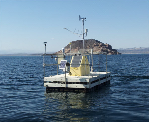
- Gauging Stations: One primary method involves the use of gauging stations strategically positioned throughout the lake. These stations consist of instruments designed to precisely measure water levels. Sensors and floats are employed to ensure accurate readings, providing real-time data on the lake’s water elevation.
- Satellite Technology: In the modern era, satellite technology has become a valuable tool for monitoring large bodies of water. Satellites equipped with altimeters can measure the distance between the satellite and the lake’s surface, allowing scientists to calculate the water level. This technology provides a broader perspective and aids in understanding regional water dynamics.
- Hydroacoustic Devices: Hydroacoustic devices, such as sonar systems, are deployed to measure the depth of Lake Mead. By sending sound waves into the water and analyzing the returning echoes, scientists can accurately determine the distance from the surface to the lakebed. This method is particularly useful for mapping underwater topography.
- Streamflow and Inflow Data: Monitoring the inflow and outflow of water is crucial for understanding changes in Lake Mead’s water level. Streamflow data from tributaries and rivers feeding into the lake, coupled with information on evaporation rates, allows scientists to predict water level fluctuations.
Technology Advancements: Recent technological advancements have enhanced the precision and efficiency of water level measurement. Automated systems, remote sensing technologies, and advanced data analytics contribute to a comprehensive understanding of Lake Mead’s hydrology.
Significance of Measurement: Accurate measurement of Lake Mead’s water level is vital for various reasons:
- Water Resource Management: The data collected informs decision-makers on water allocation and usage, ensuring sustainable management of this critical resource.
- Drought Monitoring: In times of drought, understanding water level trends is essential for implementing effective conservation measures and drought response strategies.
- Ecological Impact: Changes in water levels can have profound effects on the lake’s ecosystem. Monitoring helps assess and mitigate potential ecological impacts.
Conclusion: The measurement of Lake Mead’s water level is a sophisticated process that involves a combination of traditional methods and cutting-edge technologies. This ongoing monitoring is crucial for safeguarding the region’s water resources and maintaining the delicate balance of the ecosystem surrounding this iconic reservoir.
What Was the Deepest Point in Lake Mead Ever
As of my last update in January 2023, the deepest point in Lake Mead, the largest reservoir in the United States, was approximately 532 feet. This depth is not constant, as water levels in lakes are subject to fluctuations based on various factors, including precipitation, water usage, and climatic conditions.
Lake Mead’s depth is affected by the ongoing dynamics of inflow and outflow. In the past, the lake has experienced changes in water levels due to factors such as drought conditions in the region. During periods of drought, reduced inflow from tributaries and increased evaporation can contribute to a decline in water levels, exposing previously submerged areas and potentially altering the deepest point temporarily.
For the most current and accurate information on the deepest point in Lake Mead, especially if you are interested in specific depths at a particular time, it is advisable to consult official sources.
The U.S. Bureau of Reclamation and other relevant water management authorities regularly monitor and provide up-to-date data on lake levels and depths.
This information is crucial for managing water resources, understanding ecological impacts, and making informed decisions about water usage in the region. Keep in mind that the depth of Lake Mead can change over time, and accessing the latest data from authoritative sources will provide the most accurate and relevant information.
![]()
References:
National Park Service- Lake Meade Water Level
Bureau Of Reclamation-LAKE MEAD AT HOOVER DAM, END OF MONTH ELEVATION (FEET)
FAQ’s
- What methods are used to measure Lake Mead’s water level?
Measurement involves gauging stations, satellite altimeters, hydroacoustic devices, and streamflow data.
- Why is it essential to measure Lake Mead’s water level?
Monitoring ensures effective water resource management, aids in drought response, and assesses ecological impacts.
- How do gauging stations contribute to measurement?
Gauging stations use sensors and floats to provide real-time water level data, crucial for accurate monitoring.
- Can satellite technology accurately measure the lake’s water level?
Yes, satellites equipped with altimeters calculate water levels by measuring the distance between the satellite and the lake’s surface.
- What role do hydroacoustic devices play in measurement?
Hydroacoustic devices, like sonar, help measure depth by analyzing sound waves’ echoes and mapping underwater topography.
- How does streamflow data contribute to understanding water levels?
Streamflow data, along with inflow and outflow information, helps predict water level fluctuations and assess overall hydrological conditions.
- Are there advancements in technology for measuring water levels?
Yes, automated systems, remote sensing technologies, and advanced analytics contribute to precise and efficient measurements.
- Who monitors and provides up-to-date information on Lake Mead’s water levels?
Authorities such as the U.S. Bureau of Reclamation regularly monitor and share accurate data on lake levels and depths.