River systems can take on various shapes and configurations, and each type of river system has its own unique characteristics. What is an Oxbow River System?
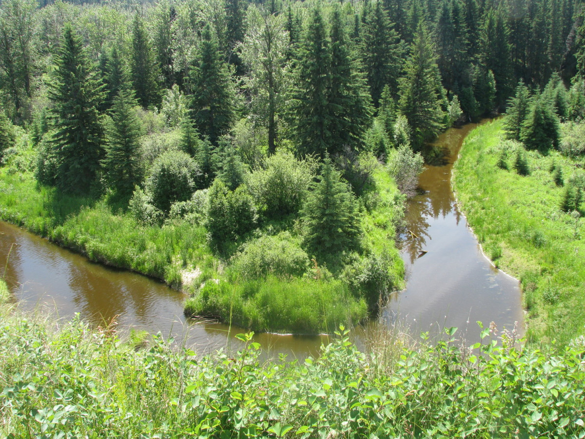
Oxbow river systems are formed when a meandering river undergoes a change in its course. This change can occur due to factors such as erosion, sediment deposition, or natural evolution when a meander in the river is cut off from the main stem & it is characterized by a distinctive U-shaped river path.
Each river system in the world has its own geological and ecological significance, and they can be found in various landscapes around the globe where land and sea meet in an ever-changing natural process.
Introduction:
There is an intriguing world of water geography, where the seemingly simple course of a river tells a story spanning thousands or even millions of years. One such tale is that of the Oxbow River System. A beautiful representation of nature’s ever-changing face, the Oxbow River System, along with its distinct Oxbow Lake, serves as a testament to the enduring and fluid dance between water and land. This article serves as a journey that guides you through the form, function, and unique water geography of the Oxbow River System.
What is an Oxbow River System
The foundation of understanding water geography starts with comprehending the details of different river systems. Among them, the Oxbow River system holds particular significance. It’s a mix of water science, environmental factors, and geology, Oxbow Rivers provide vast resources. The word signifies a U-shaped river made up of the meanders or the curves of the river resembling it. It is where Oxbow Bend another significant river location, gets its name.
The oxbow river system starts with the meandering river flowing across the valley and the landscape. It creates a gentle, winding pattern as it traverses, also known as a meander. Over time, the river meanders often become more amplified, particularly in lands that are flat and plain. As a result, the river channels constantly change and adapt, forming a distinct oxbow formation. The river then flows back inwards, creating loops touching each other. Erosion and deposition processes at the river basin further alter the river flow.
At times, a neck-like structure forms due to the very close vicinity of these loops in an oxbow river system. As time progresses, extensive flood situations push more water into these neck structures. Initially, it takes the path of a shortcut across the loops through the neck where the river’s end parts unite. Eventually, this new water path bypasses the old river loop, isolating and leaving the water inside stagnant.
A stagnant water body sooner or later transforms into an ‘Oxbow Lake’. It’s fascinating to realize that ‘Rio Beni’, a major meandering river Bolivia proudly houses, owns such spectacular oxbow lakes. If we peruse the streams and geology of River Bolivia, we will find great examples of oxbow river systems. They provide excellent teaching resources for science teachers needing concrete information and resources to explain this intricate topic to their students.
In a nutshell, the Oxbow River system is an outstanding example of Mother Nature and Rao’s river-based artistry on our land. Shaping valleys, forming lakes, and altering the course of water, it’s no less than a masterpiece of geographical science. An oxbow river system’s existence proves the river is not merely a water body; it’s a dynamic ecosystem continually shifting and shaping surrounding landscapes. Every meandering river, every oxbow bend, paints a picture on the grand canvas of environmental science, and the oxbow rivers etch a narrative of evolution, resilience, and natural decorum for posterity.
Oxbow River systems have environmental importance as they can harbor unique ecosystems and provide insights into the interaction between water and land resources
Understanding the Formation of an Oxbow Lake
Geography and geology enthusiasts probably know all about the wonder that’s an oxbow lake, but if you’re new to this, welcome. Let’s take a journey, following the twists and turns of oxbow lakes the wonder child of rivers formed from their meander. These river meanders, typically found within a valley, aren’t just any bends in the river flow. They possess an intricate formation process that invokes the beauty of science. Oxbow river systems are important in environmental science for shaping landscapes and ecosystems.
 So what exactly is an oxbow lake? Here is a sign. Its name is “Oxbow”. A clear giveaway to its unique shape, reminiscent of the U-shaped collar placed around an ox’s neck. More formally though, an oxbow lake is a special kind of lake formed from the winding path of a river, specifically, the river meanders. These river channels provide the vehicle for the creation of oxbow lakes.
So how’s an oxbow lake formed? It’s a lovely dance between water, land, flow, and time. Rivers aren’t static; they flow, they move, and in the process, they create bends or meanders. Over time, these meanders can become more pronounced, given the continuous flow and the geography of the land. At some points, these meanders can become so pronounced they almost circle back on themselves. Here’s where our friends, the banks, come into play.
The river’s bank land that ‘borders’ the river, if you will instrumental in the formation of oxbow lakes. The water flows fastest at the outside of each bend, creating a concave bank that erodes over time. Conversely, the inside concave one is where sediment dropped by the slowing water builds up. This forms what we call ‘point bars’. Over time, the point bars grow, the river’s bends draw closer together, and bingo! We have an oxbow bend in the making.
Finally, the river can change its course and flow straight(for a while at least), leaving a crescent-shaped lake in its wake. An oxbow lake. This process called the ‘oxbow formation,’ is an unforgettable lesson in science, geology, and of course, water and land resources. Understanding the formation of oxbow lakes oxbow is not just an exercise in academic pursuit. It’s deepening our appreciation of the natural world’s beauty and the dance between water and land creation. It delves into the heart of geography, geology, and of course oxbow lakes’ lake essence.
Role of the Meandering River in Shaping the Oxbow Bend
The role of a meandering river in crafting the ethereal arc of an oxbow bend is nature’s way of demonstrating a unique processional of water geography. This entity, commonly referred to as the oxbow, embodies the heart of river channels taking not the shortest, but rather the winding path of least resistance. The science behind this captivating transformation speaks volumes to the lifeblood found in the essence of flow, and its intricate influence over our earth.
When one observes a river from a high, panoramic viewpoint, its long, twisted contours may appear puzzling. At a glance, it’s hard to fathom why a river meanders rather than flowing straight down its valley. But this is where the intriguing charisma of geography and geology steps in. When a river enters a flat wide valley, it begins to meander, nimble yet relentless. The initial stream morphs into river meanders, painting a serpentine path across the tranquil landscape.
As a river twists and turns, this constant waltz gives life to the formation of an oxbow bend. The meander outward flow, vaulting into the floodplain, sculpting it as it goes, is where the oxbow’s genesis begins.
Erosion gnaws at the riverbank’s edges, causing the bend to grow until it forms an elongated loop resembling the harness of an ox, hence the term “oxbow”. This might seem subtle, yet it’s a sign of a significant change in the topography of the terrain.
This phenomenon of oxbow formation is not just a masterpiece of geographical artistry, rather, it provides invaluable resources for biological diversity. Neighboring species and aquatic life thrive in these newly formed water pockets, folks favor them for ponds or reservoirs, and they often become the focal points for recreational activities.
So next time, when you look at a snaking river or a still oxbow lake, remember this is an intricate process. Think about what a river imparts, its meandering journey, its evolution; and tales of resilience, adaptation, and change. Truly, few sites embody the synergy of science, geography, and elements as a river does, and no better teacher for the story of water than the ethereal dance of a meandering river.
Correlation between Oxbow Water Bodies and Rivers
The complex network of a river system, whether it’s a mighty powerhouse like River Bolivia in South America or a humble local stream, holds a multitude of secrets in its meandering path. As rivers flow, they carve out valleys, creating river channels, and paths often graded by the river’s momentum and the geography of the land.
One such fascinating phenomenon that is revealed in the terrain by these river flows is the formation of ‘Oxbow.’ An Oxbow isn’t exactly known in the mainstream, but it forms an integral part of our water geography, its influence so widespread that it needs no introduction to the world of science, specifically, geology.
An Oxbow is essentially a U-shaped water body that is created when a meandering river follows a wide course and eventually gets cut off from the main river channel forming a disconnected lake. The Oxbow lakes are commonly found at the outer curve of the meander where water’s erosion is most potent, leading to a sharp bend known as the ‘Oxbow Bend.’ The classified information about the science behind the oxbow formation isn’t usually in the common syllabus, but it plays a crucial role as an enriching chapter in teaching resources for geography or environmental science teachers.
You see, the river flow, in its journey from high to low land, takes the path of least resistance and turns, forming meanders under the influence of various geographical elements. The bend of meanders, over time, becomes more dramatic and finally, pinches off, forming an oxbow lake, a natural spectacle that is a reflection of the river’s history and vitality.
The oxbow lakes, fittingly named after the yoke of an ox, for their peculiar shapes also serve as vital resources, supporting aquatic life, and providing environmental diversity. In addition, they act as natural water-holding basins, preventing flooding by absorbing excess water during heavy rainfall. Oxbow lakes are a marvel of our river systems, being not just a separate water body but a silent story narrating the river’s past and present.
The relationship between oxbow water bodies and rivers is a harmonic dance of geology, dictated by raw nature. The concept of Oxbow stresses the impermanence of water geography, the continuous change in the interweaving of rivers, and streams, their meandering dance, and the creation of oxbows. The dynamic forces of nature, as seen in an Oxbow, remind us to preserve and respect every curve and meander our rivers follow in their journey to the sea.
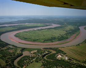
The Beni River
The Beni River flows for roughly 680 miles (1,100 km) through northern Bolivia. Scattered along the river are numerous oxbow lakes, which are curved bodies of water that form when a meander from the main stem of a river is cut off, creating a freestanding body of water. Dark green colors in the image indicate forest and lighter green shades indicate grassland or sparse forest. The Beni River in northern Bolivia spans approximately 680 miles (1,100 km). Along its course, you can find numerous oxbow lakes. These oxbow lakes are curved bodies of water that develop when a meander from the main river channel is isolated, forming a separate body of water. In satellite images, dark green areas typically represent forests, while lighter green shades indicate grassland or areas with sparse forest cover. This information provides further insight into the characteristics of the Beni River and its associated oxbow lakes.

Water Geography: Unveiling the Form and Function of Oxbow Systems
One of the vital aspects that play a significant role in shaping our land’s environmental makeup is the science of water geography. This study pertains primarily to the form and function of various water bodies, such as rivers, streams, and specifically, the intriguing river systems. These river systems work in a fascinating manner and have specific forms and structures, like the oxbow river system.
In the realm of geology, the term oxbow refers to a type of bend in the river’s flow, known aptly as an oxbow bend. This meander in the river course is what gives the river its distinctive winding shape. When a meandering river erodes one side of a bend and deposits sediment on the other, it gradually forms what’s known as an oxbow lake, often found nestled in a valley or amidst dense forest land. This process, known as oxbow formation, is an essential part of how river flow impacts the surrounding geography.
These unique river systems like the river Bolivia, known for its iconic meanders that snake through the river basin, play a crucial role in how these water bodies interact with the rest of the environment. The river meanders, carve landscapes, and deposit rich resources of soil and sediment in their wake, nurturing the surrounding areas and setting the stage for the evolution of a unique river system.
River channels are the highways that transport significant amounts of water and sediment across significant distances. These river channels draw much of their water from streams that feed into them, all of which eventually contribute to creating the river basin. And at each bending point, where the river meanders, these oxbow bends come into existence.
To sum up, the understanding of an Oxbow River System forms a crucial part of water geography, giving us a comprehensive insight into water bodies, rivers, and the detailed geometry of river flow across the earth.
Conclusion:
Understanding the Oxbow River System, its form, and Oxbow Lake’s formation is central to comprehending water geography. These curious continuities of nature serve as teaching moments of the earth’s dynamism and the tangible impact of water in shaping geographical landscapes. This knowledge allows us to appreciate the fascinating interplay between the forces of nature and geography, aiding in safeguarding such ecosystems from human activity. Armed with this awareness, we can contribute to the stewardship of our planet. Exploring the Oxbow River System is just dipping our toes into the wide, exciting world of water geography.
![]()
References:
Brazos River Authority-What is an Oxbow?
Science Direct- Oxbow Lakes
FAQ’s
Q: What is the origin of the term ‘Oxbow’ in relation to rivers?
A: The term ‘oxbow’ comes from the resemblance of meandering river curves to a U-shaped metal piece commonly used in farming, known as an ‘oxbow’. ‘Oxbow Bend’ is a term that signifies significant river locations that follow this U-shaped bend.
Q: How does an oxbow river system form?
A: An oxbow river system forms from a meandering river that flows across a landscape and creates a winding pattern or meander. Over time, these meanders can become more pronounced, especially in flat and plain areas, leading to constant changes in the river channels and forming a distinct oxbow shape.
Q: What causes the formation of an ‘Oxbow Lake’ within an oxbow river system?
A: ‘Oxbow Lakes’ form when significant changes occur in an oxbow river system, usually during extensive floods. These floods push more water into ‘neck’ structures, formed due to the close vicinity of the loops in the river system. Over time, these neck structures begin to serve as shortcuts for the river flow and eventually isolate the stagnant water within the old river loops, leading to the formation of an oxbow lake.
Q: What are some real-world examples of the oxbow river system?
A: One real-world example of the oxbow river system is the ‘Rio Beni’, a major meandering river in Bolivia. The Rio Beni, with its oxbow lakes, serves as a significant example and resource for understanding this system.
Q: Why do oxbow river systems hold importance in environmental science?
A: Oxbow river systems hold importance in environmental science for their distinctive role in crafting geographical landscapes and harboring unique ecosystems. They provide invaluable information about the interaction between water and land resources, emphasizing the river’s role in shaping the surrounding landscapes and evolving over time.
