
The DART program is a real-time monitoring system that provides data for forecasting tsunamis using a buoy and sensors on the ocean floor that measure the height of the water’s surface above the seafloor, water pressure, and Seismic activity and sends an alert if it detects possible tsunami-like activity. Is there a Tsunami Warning for the East Coast?
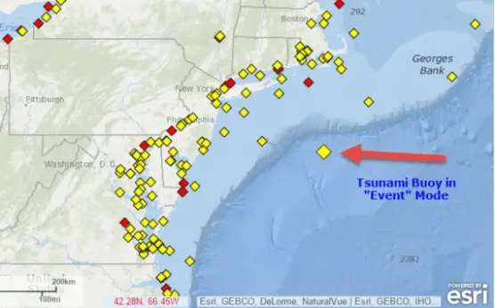
Yes, There is 1 Deep Ocean Buoy called a DART located off the coast of Atlantic City that is listed by NOAA as DART # 44402. It’s 1 of 47 DARTS that are placed around the world gathering information to send back to the NOAA Center for Tsunami Research which helps detect Tsunamis in real-time 24-7.
I lost my home in Superstorm Sandy in 2012 after being forcibly evacuated because of huge waves that were headed towards the coastline where we lived near Atlantic City. The waves were detected hundreds of miles out in the Ocean. We thought it was a Tsunami for sure. Soon after the storm, a DART was Buoyed off the coast of New Jersey.
Why would there be a Tsunami Warning System on the East Coast?
Is There a Tsunami Warning System Off the US East Coast
We have seen horrible images of the Tsunami waves covering the beaches and the cities in India, Thailand, and Sri Lanka, and recently in Japan. We always heard the possibility of this happening in Hawaii, California, and the Pacific Ocean but what about the Atlantic Ocean? Are there Ocean Buoys off the East Coast? Could something like that happen here in the US?
An approaching Tsunami can be recognized in a few ways. One method is from direct human recognition of certain clues such as earthquake shaking or an initial recession of the sea. We have seen pictures of the victims that were walking on the beach in Indonesia and the sea would start to recede so much that a boat a 1/4 mile out in the ocean would be sitting on the sand. This was a dramatic indication that an approaching Tsunami wave was going to follow.
Another method of warning would be the occurrence of an earthquake. Underwater earthquakes normally precede a Tsunami. Not all earthquakes carry a Tsunami. So there is no definitive indication that one will happen or not happen. This leaves a lot of false alarms for coastal communities.
A Tsunami Wave can travel at 400 miles an hour which will give no warning to people who are living in coastal communities. Scientists needed to come up with a bigger approach so that information could be collected far out in the ocean long before the wave reached the shore.
This valuable method of information gathering can be accessed and used to alarm people, giving them enough time to get to higher land, and saving many lives.
Special open-ocean tsunami buoys and coastal tide gauges can help by sending real-time information to Scientists at tsunami warning centers in Alaska and Hawaii. There are areas where tsunamis are likely to occur, and if or when they do occur, these Tsunami Warning Centers help train community managers, educators, and citizens to provide eyewitness information that is expected to aid in the prediction and detection of tsunamis.
Detecting Tsunamis populations at risk became a worldwide effort by the NOAA National Oceanographic and Atmospheric Administration after the Tsunami happened in Sumatra in 2004. The NOAA stepped up its efforts by:
- Developing tsunami models for at-risk communities
- Staffing NOAA warning centers around the clock
- Expanding the warning coverage area
Deploying Deep-ocean Assessment and - Report of Tsunamis (DART) buoy stations Installing sea-level gauges
- Offering expanded community education through the Tsunami Ready program
The United States took charge of gathering worldwide information and training people to provide a network and monitoring system that would help solve the mysteries of the increase of Tsunamis and away from sharing scientific information with the rest of the world. All at the NOAA Center for Tsunami Research.
The National Tsunami Warning Center serves the continental United States, Alaska, and Canada. It’s open 7 days a week and 24 hours a day. The Pacific Tsunami Warning Center directly serves the Hawaiian Islands, the U.S. Pacific, and Caribbean territories, and the British Virgin Islands and is the primary international forecast center for the Pacific and Caribbean Basins.
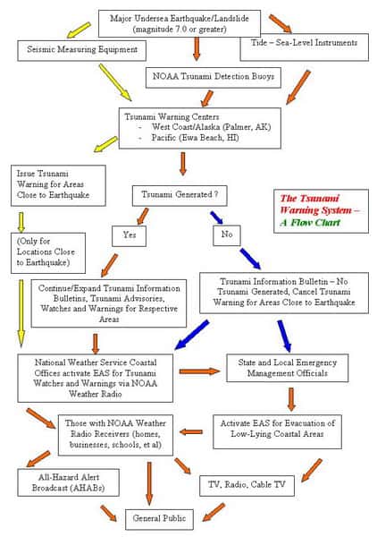
How Does the Tsunami Warning System Work
The real-time Tsunami Buoy System is comprised of two parts: the bottom pressure recorder (BPR) and the surface buoy with related electronics for communicating with the satellite system. The BPR monitors water pressure with a resolution of approximately 1 mm of seawater with 15-second averaged samples. Data is transmitted from the buoy via an acoustic modem, and data is transmitted from the buoy via the GOES Data Collection System.
Under normal conditions (no tsunami) the BPR sends data hourly that is comprised of four 15-minute values which are single 15-second averages. The BPR can make up to 3 tries to get acknowledgment from the surface buoy that the data were received. The message, identification, and location are GPS coordinates.
Over the last 20 years, the NOAA has developed a system called the Dart system. The Dart System is a seafloor bottom pressure recording (BPR) system capable of detecting tsunamis as small as 1 cm by a moored surface buoy that gives real-time communications.
An acoustic link is used to transmit data from the BPR on the seafloor to the surface buoy. This information is relayed from the Buoy on the Surface of the water to the Hurricane Center by GPS and is collected and analyzed by experts from around the world and used as real-time data that is updated constantly.
These Deep Ocean Tsunami Detection Buoys help confirm the existence of underwater waves that are generated by earthquakes and record changes in Sea levels hundreds of miles out in the deep ocean. A large devastating wave moving across the ocean floor would be picked up by the Dart System that combines a sensor on the ocean floor (BPR) connected to a Detection Buoy sitting on top of the ocean and sent directly to the Center.
The Deep Ocean Assessment Tsunami or DART has 2 modes of Communication a Trigger Mode and a Request Mode
Tsunami Warning Center
Because of the danger involved with the speed of the Tsunami’s Deep Water Detection Buoys have to be located in strategic locations where the likelihood of a Tsunami may happen. Near enough to potential earthquakes, epicenters detect seismic activity but are not so close that that activity disrupts their functioning.
DART system combines a surface buoy and a sensor on the ocean floor with a Scientist that can interpret the information providing more time. This sensor detects small changes in water pressure and seismic activity and transmits the data back to the surface.
Back at the Centers, scientists plug the data into pre-existing models. If they think a Tsunami is happening, These models predict the height, the arrival time, and the coastal locations that the tsunami will hit. Watches and warnings are issued to the affected communities so preparations can begin.
Today, 47 DART stations are positioned all around the world ready to detect and warn coastal communities about the next potential tsunami. With the DART system and Tsunami Warning Centers in place, we are now better prepared to predict a killer wave before it strikes.
If these changes indicate a tsunami may form, the buoy signals an alert via satellite to the Tsunami Warning Centers in Alaska and Hawaii. They feel it is our best effort to gather and use the information before the waves are formed.
Although the Dart program along with the BPR has been deployed in all oceans all over the world, buoys have been criticized for a high failure rate and are subjected to the harsh environment and the cost to keep them going. There is a lot of cost and maintenance involved. Ships need to be sent out miles into the deep ocean to replace or fix the Buoys
Tsunami System Warning
It can be many miles long, from 1 to 100 feet high, traveling at 400 miles per hour. This ocean monster is known as a tsunami and it can wreak havoc on coastal populations and landscapes. In deep waters of up to 3.5 miles deep where they develop, the same wave might be almost undetectable but as it gets closer to land in shallower water and builds in force they reach incredible heights.
Emergency managers in these coastal regions are in urgent need of operational tools that will provide accurate tsunami forecasts as guidance for rapid, critical decisions in which lives and property are at stake. The more timely and precise the warnings are, the more effective actions local emergency managers take and the more lives and property can be saved.
Recent advances in tsunami measurement and numerical modeling technology are being integrated to create an effective tsunami forecasting system. Neither technology can do the job alone.
The first signs are the most important because of the time constraints on interpreting data for the dangerous occurrence. Seismic parameter estimates and Tsunami measurements along with information on waves and sea levels are all combined to create a model that is compared to other information that has to be put all together by Scientists at the NOAA Center. Sound complicated? It’s very complicated. That is why The DART information is so critical.
Japan has also made an enormous amount of structural changes since the destruction of the Kobe earthquake in 1995. More and more buildings now are being made with dissipation structural devices. The Japanese people learned a hard lesson in Kobe and were embarrassed by the level of damage, so they tried to correct most of the known defects in the intervening years.
The effects of the Fukushima Power Plant and backup generators that failed after an hour, forcing local governments to bring in mobile generators were all a result of the Tsunami. Since then the Japanese have improved the Power Plants to withstand large earthquakes and are considered at the top of Tsunami Preparation.
Tsunami (soo-NAH-mee) is a Japanese word meaning harbor wave.
Approximately every 15 years a destructive, ocean-wide tsunami occurs.
A tsunami can travel around 40 mph in 100 feet of water and as fast as 475 mph in 15,000 feet of water.
Tsunami Strike Japan!
“There are a whole bunch of monitors around the planet that are set up to record earthquakes and if these are large enough, they may generate tsunamis”, explains Professor James Goff, director of tsunami science at the University of New South Wales.
“When any event like this happens these sensors all around the world instantaneously pick up a signal”.
In addition to earthquake sensors ,’dart buoys’ or tsunami buoys float in the deep ocean in different places around the world.
“They are specially set up to detect and record the passing of a tsunami wave”, says Goff.
“As soon as the wave passes that point you know how long it’s taken to get from the source and how big the wave is at that point so you have some idea of what’s coming. Islands have tide gauges too which help track a wave across the Pacific”.
Once the information passes up to the satellite and onto the Center, it’s up to the scientists to run it through their modeling software and determine how bad the situation is with the Emergency officials in the coastal areas where decisions need to be made.
The signals for a Tsunami may be small so certain criteria are used to decide whether a warning is to be sent out.
“Generally if an earthquake is over 6.5 and is happening at between 0 and 5 kilometres depth beneath the seafloor they’ll send out a tsunami warning”.
The warning can go out as little as 3 to 5 minutes after an undersea earthquake. These warnings go out all over the world to all countries that may be affected by them. This has been the protocol since the 2004 Tsunami.
Most of what is standard today is in the way of Tsunami technology and procedures, even the Center was built because of the 2004 Tsunami that killed so many people. Residents of Tokyo likely had about 80 seconds of warning before a devastating quake rumbled through the city after striking 373 kilometers away, off Japan’s northeast coast.
The seismographs detect the first signs of a quake in Japan. They had 1000 or more instruments that detect earthquakes back in 2011. The DART Systems went from 6 original monitors in 2001 to 39 in 2008. The BPR that was used had one-way communication and the 2nd generation had the 2-way satellite-connected BPRs. While it only gave a few minutes of warning time to the people of Japan officials from Japan believe this was enough time for surgeons to stop an operation in a hospital or for people to pull over to the side of the road.
And for people to get out of elevators at work before the major shockwaves started. 2 minutes was just enough time for people who are used to earthquakes and who know what the siren that is alarming through the country meant because have experience with disasters.
While tsunamis are fast, they are not as fast-moving as earthquakes themselves. Tsunamis travel as fast as jet aircraft in deep water as fast as 450 mph. where they are spread over a far deeper water column and make for smaller and very gradual waves at the surface.
They start to slow down and produce higher waves in shallower water. Residents of the hardest-hit areas likely only had 15 minutes of warning, though Tokyo would have had at least 40 minutes of warning after the quake.
Tsunami Warning Center Preparedness
It was about Surfers in Southern California who would collect and document information concerning the wave conditions in their part of the world. The information can be collected and added with other Surfers in coastal towns in other parts of the country and the world via the internet and GPS setting the Tsunami flow chart in motion right on their cell phones.
Surfers in other parts of California, Hawaii, and Australia, are doing the same thing. With that information they added, new data will be provided from the areas of the world directly to data banks at the Center For Tsunami Research.
Fisherman also has first-hand knowledge of information that they use in their part of the world and during the day. They have everyday access to the ocean and would be the person to ask about things that are changing. Because the world is getting smaller The Center can use this visual information as a reference or for their modeling software.
In 2010, A giant earthquake happened in the middle of the off the coast of Chile. The Tsunami arrived on the coast at Talcahuano Chile which was at the epicenter approximately 30 minutes later. The water flooded most of the coastline.
The Port of Talcahuano, Chile suffered major damage caused by numerous Tsunami waves estimated at 19 feet high. These waves traveled miles inland past the Port. The death toll would have been a lot higher if the population of Chile had not been educated.
Some pathways and roadways had signs to lead people to safety for evacuation. In this event, an earthquake caused Tsunami waves that were detected by The DART monitor that picked up the information caused by the wave that was sent to the Buoy that transmitted the data to the Center where it was used to formulate a model that Scientists could use to predict how severe the event would be.
The power and destination which was determined to be Hawaii. Once these conditions are authenticated they are given to TV Radio and the Internet to be broadcast throughout the regions where the model’s show would be affected. This all happened the night within 30 minutes in Chile.
A tsunami is a series of ocean waves caused by any large and sudden disturbance of the sea surface. Tsunamis can be generated by landslides, volcanic eruptions, or even meteorite impacts in the ocean. But they are most often caused by an earthquake where there’s a sudden displacement of the ocean floor.
When that happens, there’s a transfer of energy from the seafloor to the ocean, causing waves on the surface to radiate outward in all directions. In deep waters, these waves may not even be detectable or minute in measurement. But when the tsunami enters shallower waters that are closer to the shoreline, the wave speed slows, and its height increases.
The water along the coast may recede noticeably. A large wall of turbulent water called a “bore” may also form. When the tsunami hits the coast, it may come ashore like a fast-rising flood and strike with devastating force. The series of waves may continue for hours.
The first one may not be the last or the largest. For your safety, know the potential warning signs of an incoming tsunami: a strong earthquake that causes difficulty standing; a rapid rise or fall of the water along the coast. You may hear the roar of a jet plane sound. A tsunami can travel around 40 mph in 100 feet of water and as fast as 475 mph in 15,000 feet of water.
Tsunamis range in size from inches to 100 feet. They create what sounds like sonic booms that are in the area.
As tsunami waves move into shallow water, the wave height can increase by over 10 times.
Tsunamis Warning System Today Live
Right here MyWaterEarth&Sky Tsunami Live Feed page
You can get LIVE instant information on the East Coast from DART # 4402 on the coast of Atlantic City NJ The West Coast from the Western Pacific off the coast of San Francisco California from DART #46059 Or straight from NOAA from their website.
Each DART Station has live updated information along with living pictures and weather conditions that are delivered at short intervals and sent to NOAA to be analyzed and recorded. You can see the changing patterns before it moves onto each coast.
If you are on the coastline or the beach and you feel the earthquake or see the water withdraw or hear loud noises much like a jet plane. You will be likely to be observing what is happening. Evacuate immediately to High Ground, Following the Tsunami Evacuation Signs. If you can’t get to an evacuation center don’t wait, head for a building with a high roof.
Carry your cell phone by this time as the emergency broadcast will already be taking place wherever the event is happening. You need to be 100 feet above sea level Tsunami waves will come again and again do not leave your Emergency area thinking it’s over until you know for sure.
The chance of these Tsunamis happening on the East Coast is small but most people that I have talked to said in the last 10 years the Jersey Coast has doubled the number of storms in its history. New Jersey experienced an earthquake that summer a few months before Sandy.
There were sonic booms and some odd weather patterns that have now gotten better. The reality of Global Warming has no doubt caught up to us. Superstorms and Unusual Weather Patterns are expected to continue for communities on the Eastern Seaboard for years to come.
Conclusion:
The DART program is a real-time monitoring system that provides data for forecasting tsunamis using a buoy and sensors on the ocean floor that measure the height of the water’s surface above the seafloor, water pressure, and Seismic activity and sends an alert if it detects possible tsunami-like activity. Most of these alarm systems are in the Pacific Ocean where Tsunamis happen. How about the East Atlantic Ocean?
Yes, There is 1 Deep Ocean Buoy called a DART located off the coast of Atlantic City that is listed by NOAA as DART # 44402. It’s 1 of 47 DARTS that are placed around the world gathering information to send back to the NOAA Center for Tsunami Research which helps detect Tsunamis in real-time 24-7.
![]()