The annual inflow to Lake Meade has increased dramatically over the past 50 years as a result of the rapid population growth in Las Vegas and the Southwest area of the U.S. Are there historic records for Lake Mead’s water level?
Yes, Lake Mead’s elevation has shown historical patterns influenced by factors like drought & water usage. Fluctuations are common, & sustained low levels can significantly impact water supply. Monitoring water resources in the region is crucial to address challenges related to the lake’s elevation.
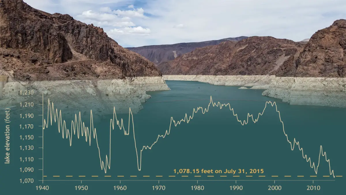
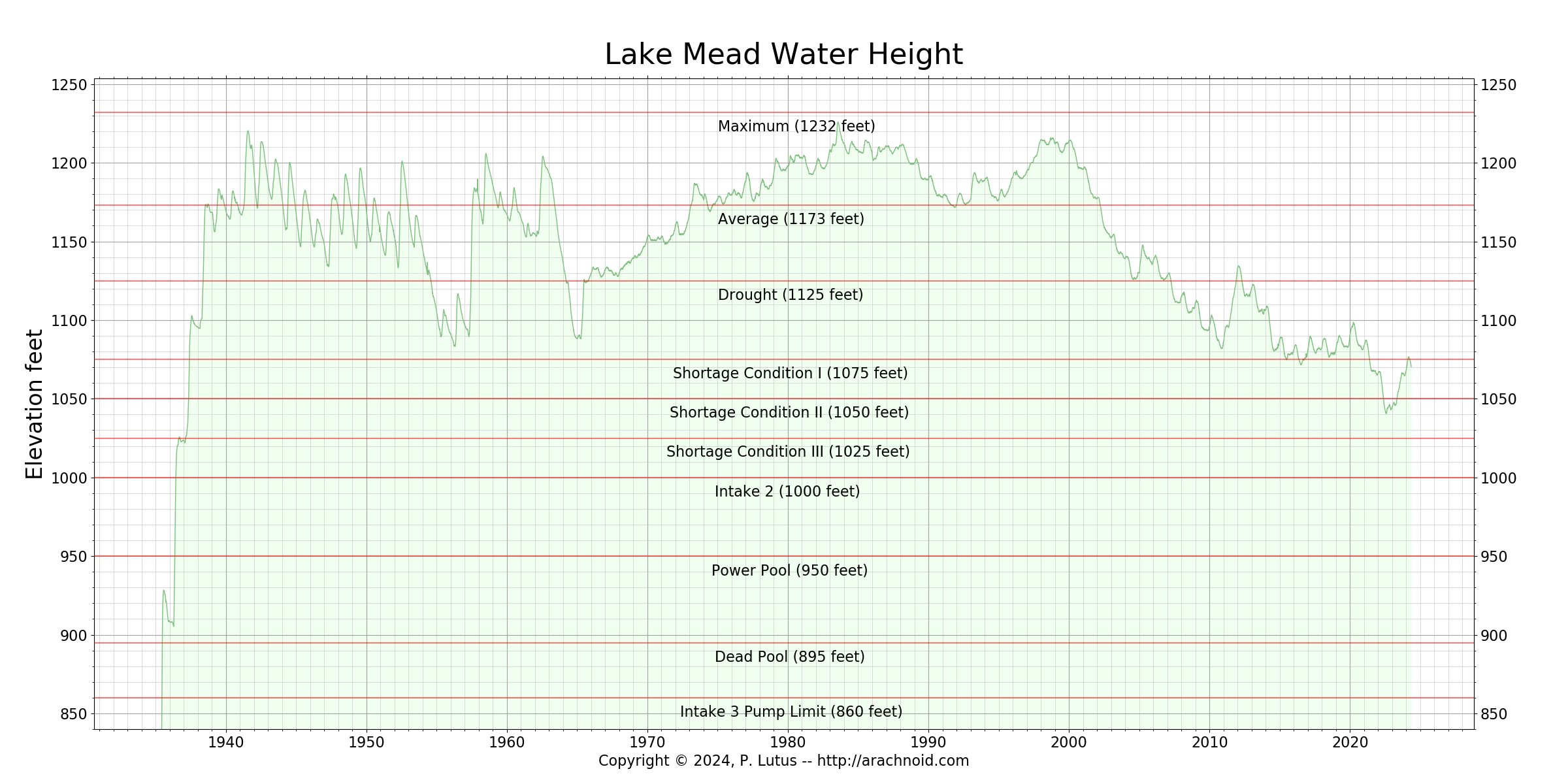
Lake surface elevation reflects the inflow-outflow regime, and large differences in elevation are primarily a reflection of drought years. Lake Mead began filling in late 1934 and the average daily surface elevations from 1 February 1935, when elevation data began to be collected, through 2009
Introduction:
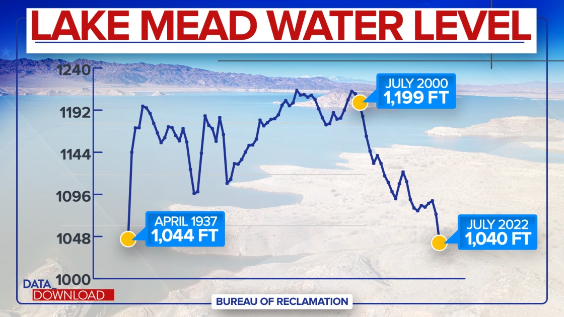
Historical statistic patterns in Lake Mead’s elevation reveal significant fluctuations over the years. The reservoir, initiated in late 1934, took nearly three years to reach an elevation of 1,044 feet in April 1937 Notably, at its peak in July 1983, Lake Mead soared to an elevation exceeding 1,225 feet. Historical patterns are influenced by factors like drought and water usage. Fluctuations are common, and sustained low levels can significantly impact water supply and ecosystems. Factors like climate change and water management practices also contribute to these patterns. Monitoring and managing water resources in the region are crucial to address challenges related to the lake’s elevation.
Are There Historic Records for Lake Mead’s Water Level
Lake Mead, a key reservoir along the Colorado River, boasts a rich history documented through its water levels. Historic records meticulously track the fluctuating depths of this vital body of water, reflecting the complex interplay of natural forces and human activities. Since its formation following the completion of the Hoover Dam in the 1930s, Lake Mead has served as a crucial water source for millions of people in the southwestern United States. These records not only chronicle the ebb and flow of statistical water levels but also offer insights into broader environmental trends, such as periods of drought and the impacts of climate change. Moreover, they underscore the importance of effective water management strategies to sustainably steward this invaluable resource for future generations.
Lake Mead Water Levels — Lake Level Historical Lake Elevation Statistic Records
Lake Mead’s water levels exhibit distinct historical elevation patterns influenced by various environmental factors. Fluctuations in precipitation, prolonged droughts, and changes in water demand contribute to the observed patterns. Understanding these historical elevation trends is crucial for implementing effective water management strategies to ensure the sustainability of water resources in the Lake Mead region.
The reservoir of Lake Mead, amidst the rugged contours of the Grand Canyon and the arid expanse of Las Vegas, finds its history etched in the varying lines of its lake elevation. As the principal reservoir of the mighty Colorado River, the story of Lake Mead’s statistic water levels is interwoven with the environmental narrative of the American Southwest. Over the years, historical patterns recorded in the geological ledger unveil a tale of dramatic fluctuations, with the lake’s elevation wrestling against forces set in motion by nature and humankind alike.
 Harkening back to its inception, we decipher telltale signs that Lake Mead’s water levels have weathered historic highs and lows, with large differences in elevation punctuating its storied past. The lake’s high watermark, a testament to seasons of abundance, has on occasion soared to impressive heights, reaching menacingly close to the top of the Hoover Dam spillways.
Yet, these peaks are mirrored by periods of daunting low levels, where receding waters at Lake Mead have laid bare vast expanses of the lake bed, converting aquatic realms into lunar landscapes.
The stark dissimilarities in Lake Mead water levels statistic over decades manifest the lake’s history of hydrological volatility. Drought years particularly underscore this fragile equilibrium, where the lake’s elevation plummets, alarming those who gaze upon its dwindling breadth.
In these times, the reservoir has tumbled hundreds of feet below its fullest capacity, leaving docked vessels high, dry, and miles from the retreating shoreline.
Water Level-Older Lake Elevation-Lake Levels in Feet
At its pinnacle, Lake Mead’s elevated waters have touched well above sea level, brimming with the Colorado River’s liquid bounty. Today’s reality, however, confronts us with an antithetic scenario that reveals the Statista historical patterns of this vast basin’s susceptibility to climatic oscillations. Low levels in recent years have stripped the reservoir to a mere fraction of its potential, pushing its water levels far beneath their historical average.
Yet, these historic lows are not merely statistics and numbers; they’re physical benchmarks that punctuate the very real consequence of prolonged aridity in the Colorado River basin. As the water levels continue their relentless descent, once-submerged secrets emerge from the deep water’s past years.
Las Vegas stands sentinel over this tumultuous journey of Lake Mead’s water levels, a historical pattern that’s as much about human influence as it is about natural flux. The city’s reliance on the reservoir for life-giving water starkly contrasts with the lake’s somber retreat, charting a course through changing climatic narratives with profound implications for the future of the Southwest’s water supply – a history told in the ebbs and flows of Lake Mead.
The feet above sea level have descended alarmingly, enough so that historians and scientists alike are scouring lake bed archives for patterns. Indeed, the historic variations in lake levels at Lake Mead have crystalized into a warning, a reflection mirrored in the ebbing lake surface; it’s a history lesson offered in increments of elevation, stressing upon us the precarious balance we maintain with our environment.
Is There a Change in Lake Mead’s Water Level Elevations
Yes, there has been a notable change in Lake Mead’s water level elevations over time. The lake has experienced fluctuations, with periods of declining water levels attributed to factors such as prolonged drought conditions, increased water demand, and climate variability.
These changes emphasize the importance of continuous monitoring and adaptive water management strategies to address the challenges posed by evolving environmental conditions in the southwestern United States.
As the receding waters of Las Vegas’ fabled Lake Mead drawback, they’re unmasking a tale deeply etched into both the history and geography of the region. There’s indeed a significant change in Lake Mead’s water level elevations—a testament to the interplay between nature’s whim and human influence. This once-expansive lake, fed by the mighty Colorado River, is now experiencing alarmingly low levels, revealing large differences in elevation that were once submerged beneath its tranquil surface.

Over the years, when discussing statista Lake Mead, you can’t help but speak in terms of water level changes. In historical context, the drought years have been particularly unkind to the lake, diminishing its volume and, thus, altering the elevation pallet of its banks.
The present state is a far cry from the high water marks that used to define the lake as a robust reservoir. Nowadays, as you stand on the shores that were once feet above your head, you witness the stark reality: water levels have dropped drastically, and the lake’s plight is palpable.
The sheer magnitude of Lake Mead’s receding waters illuminates an eclectic timeline, showcasing where the water once reached – the high elevation marks now laid bare for all to see. Historically, Lake Mead flowed abundantly, its levels were influenced less by drought and more by the natural variability of the Colorado River.
In the drought-stricken epoch we’ve entered, the lake levels have sunk to new lows, making the large differences in elevation even more pronounced. Such change, while historic, also rings a bell of urgency, igniting discussions on sustainability, conservation, and the future of the lake’s feeder—the Colorado River.
The lake’s history is not just etched in textbooks but also in the receding shoreline itself; each foot below where the water used to tell a different part of Lake Mead’s story. This drastic change in water levels beckons a thorough examination of how we manage both the lake and the lifeline that feeds it—emphasizing the need to balance our water level aspirations with the stark reality of the dwindling Colorado River.
Lake Elevation Water Levels and Inflow: Analyzing the Lake Mead Water Level Data
As the waters of Lake Mead retreat, a captivating tableau emerges, threaded with historical patterns that have been veiled beneath the surface for ages. The lake levels have become a crucial barometer for assessing the impact of drought years on this reservoir—integral to Las Vegas and the greater Grand Canyon region.
Each receding foot of water reveals more of the lake bed, grounding boat ramps that once floated above the Colorado River’s generosity. The inflow data, meticulously recorded, becomes a narrative of nature’s ebb and flow, as well as the direct repercussions of human demand.
Within this web of information, we find Lake Mead water levels are not just numbers on a graph but a story of elevation, conservation, and the stark reality of climate change. The historical patterns etched into the Lake Mead perimeter are maps to understanding.
Analyzing the sequential drop—feet by feet—the data exhibit a descent, with recorded elevations once thought steadfast now seemingly a relic of wetter eras. Amidst these findings, the Colorado River’s waning inflow only intensifies the pressure on planning for Las Vegas’s water future.
Delving deeper into the archival records of Lake Mead’s water levels, we’re faced with the incontrovertible force of change. Elevation markers, once submerged, now stand meters above the quivering surface, bearing witness to years when the inflow could not keep pace with the arid breath of drought.
Capturing premium statistic data annually has been vital in recognizing trends and preparing for the years when the lake bed is more beach than the basin. It’s a precarious balancing act: to ensure water levels sufficient to sustain the ecological life, the thirst of cities, and the silent plea from the depths of Lake Mead’s premium statistic history.
Siecing through this treasure trove of data, experts aim to bolster the resilience of Lake Mead against future drought years. The elevation of concern could not be higher as analyzing the complexities woven through the inflow and water levels uncovers a pattern as intricate as the Grand Canyon itself.
Lake Mead’s contemplative expanse beckons a more profound reflection on our dependence on the Colorado River, a source we have so long believed inexhaustible. The receding water levels stand as a testament and a warning—a call to arms to respond to the environmental clarion before the lake bed’s whispers become echoes of a verdant past.
Analyzing Lake Mead’s levels and inflow data provides crucial insights into the reservoir’s hydrological dynamics. By examining the relationship between water levels and inflow rates, scientists and water management authorities can understand the impacts of climate variations and human activities on Lake Mead. This data-driven analysis is instrumental in formulating effective strategies for sustainable water resource management in the face of changing environmental conditions.
How Lake Mead’s Water Level Elevations Fluctuate Over the Years
Over the years, the fluctuations of this crucial water basin have caught the attentive eyes of scholars and citizens alike, particularly as the receding lake waters kindle conversation around water shortage and climate patterns. The lake surface itself, having been a barometer of the Southwest’s hydration status, tells a story deeper than Lake Mead and its dwindling depths.
Historically, Lake Mead’s elevation didn’t waver as starkly as it has during recent drought years. It’s been documented that decades before the lake levels consistently stood many feet above the troubling thresholds we see today. Yet, the imprints of change are as clear as the watermark rings around the basin’s perimeter, signaling a retreat forged by persistent water level deductions.
As Lake Mead continues to recede, the waves of the past seem to echo the undulating patterns of fluctuation, premium statistics each recession, and replenishment a chapter in an ongoing saga of sustainability and growth.
Lake Elevation Insights: Older Lake Mead’s Feet Above Sea Level
Lake Mead’s elevation, measured in feet above sea level, is a critical indicator of the reservoir’s health and water availability in the southwestern United States. The lake mead water level history and elevation vary based on factors such as precipitation, temperature, and water demand.
Historically, the lake has experienced fluctuations, with periods of both rising and falling water levels. Monitoring this metric is essential for assessing the impact of climate change, drought, and human activities on the region’s water resources. As the elevation changes, it directly influences water supply, ecosystems, and the overall resilience of the Lake Mead reservoir.
Gazing upon Lake Mead, one witnesses the storytelling ripples of elevation insights that unfurl historical patterns etched into the landscape. The feet above sea level — a metric so often quoted becomes a narrative of nature’s fluctuating canvas.
 It was noted, with a tinge of concern, that lake levels have been dramatically declining, a testament to a tale of drought years and climate rhythms. As the lake bed is gradually unveiled, each receding foot uncovers chapters of history that we’re now compelled to read.
The myriad of feet etchings above the once-submerged ground brings forth a startling realization of large differences in elevation, a stark indicator of the lake’s manifold states through time.
Lake Mead’s water level whispers a story of abundance and scarcity, the lake surface serving as the measure of its breath. In grasping the importance of elevation, one fathoms the profundity of every foot’s departure, revealing an unvarnished truth about our shared heritage and a watery legacy we can’t ignore.
Continuing exploration into the majestic terrains of Lake Mead unearths a history written not in pages, but in feet above sea level.
We’ve charted fluctuations, and seen the crests and troughs of water-level landscapes, leading us to ponder—how do Lake Mead’s elevations vacillate over the years? Are we merely bystanders to nature’s grandeur, or do we find ourselves inadvertently scripting the scenario? Notably, it is the lake levels and inflow data that give us foresight into the climatic narrative, as every foot foretells the impending future.
Understanding the Older Elevations of Historic Lake Water Level
Beneath the scorching Nevada sun, Lake Mead’s vastness has ebbed, revealing a story etched in its parched lake bed. This lake, holding the lifeline of Las Vegas, whispers its history through older elevations now laid bare for the world to discern. The historical patterns of lake water levels of fluctuating fortunes, where drought years and water shortages have become recurring topics of concern. As water levels dwindle, reminders of a wetter past emerge in the form of boat ramps leading to nothing
Understanding these older elevations at Lake Mead is akin to peering through time, uncovering the climate’s secrets trapped in sediment and stone. To glean the full story of this historic lake’s elevations requires grappling with the reality of a lake that’s witnessed both bounty and scarcity.
The Lake Mead levels, now receding, serve as a tangible measure against the elevation benchmarks etched into the canyon walls, symbols of a high-water past now out of reach. In recent times, one can’t help but notice the historic trend—a downward trajectory—that bespeaks a grimmer water level narrative for Las Vegas’ thirsty populace.
Elevation insights, specifically Lake Mead’s feet above sea level, offer a quantifiable glimpse into this saga. As the water level continues its resigning dance, historic Lake Mead appears as a shell of its former glory.
The historical elevation patterns now exposed tell a tale. These lake levels once marked consistently higher on every ranger’s chart, now illustrate a starkly different story—one of caution and, perhaps, a warning for the future for the Southwest region.
Yet, as Lake Mead’s levels retreat, history doesn’t merely fade but offers keys to understanding. Each elevation marker uncovered on the lake bed corresponds to a time when the water level was not just a statistic but was the lifeblood of communities and ecosystems. As researchers dig into lake levels and inflow data, they confront the challenge of deciphering the complex interplay between nature’s caprice and human demand. Lake Mead’s historic declining elevation, year over year, isn’t simply a footnote in history.
Conclusion:
Lake Mead’s elevations have exhibited dynamic fluctuations over the years, driven by a combination of natural and anthropogenic factors. Climate variability and drought conditions play a pivotal role, in impacting precipitation and water inflow into the lake. The demands for water resources, coupled with hydroelectric power generation activities at the Hoover Dam, at Lake Mead, contribute to the complexity of these fluctuations. Effective water management policies and reservoir operations are crucial for addressing challenges posed by changing elevations. Monitoring historical data provides valuable insights for sustainable water resource planning in the face of evolving environmental conditions.
![]()
References:
National Park Service-Lake Meade Historical Timeline
FAQ’s
- How does historical data help predict future water levels?
Analyzing past trends helps in understanding patterns and making informed predictions.
- What are the consequences of low water levels at Lake Mead historically?
Reduced water supply, impacts on ecosystems, and challenges for water-dependent industries.
- How is historical data collected and maintained for Lake Mead?
Data is gathered through monitoring stations, satellite imagery, and records from water management agencies.
- Have there been historical instances of extreme water level fluctuations?
Yes, periods of both high and low water levels have been documented over the years.
- What measures are taken to address water level challenges based on historical data?
Water conservation initiatives, drought management plans, and policy adjustments are implemented.