
The king tide is the highest predicted high tide of the year occurring at a coastal location. It is above the highest water level reached at high tide on an average day. King tides are also known as perigean spring tides. What causes a King Tide?
A King Tide is used to describe an especially high tide event occurring twice a year and is caused when there is an alignment of the gravitational pull between the sun and moon. It occurs naturally, & regularly and is predictable when the earth comes closest to the sun around Jan. 2.
By knowing how King Tides and Currents work we can understand how the Rising Sea Levels will act in the future as the ocean waters warm up and move naturally toward shorelines.
What Causes a King Tide
A King Tide is a non-scientific term that describes abnormally high tides that affect shorelines in coastal regions. These tides are enhanced when the Earth is closest to the Sun around January 2 of each year. These huge tides come only twice a year, causing Ocean waves to surge onto the beaches. They are reduced when it is furthest from the Sun, around July 2.
When King Tides occur during cyclones, floods, or storms, water levels can rise to higher levels and have the potential to cause great damage to property and the coastline.
To understand what causes King Tides you need to know what causes Tides here on earth. Gravity is one major force that creates tides. In 1687, Sir Isaac Newton explained that ocean tides result from the gravitational attraction of the sun and moon on the oceans of the earth
Newton’s law of universal gravitation states that the gravitational attraction between two bodies is directly proportional to their masses and inversely proportional to the square of the distance between the bodies The greater the mass of the objects such as the Earth, Moon, and Sun, and the closer they are to each other, the greater the gravitational attraction is between them.
Tides are long-period waves that move through the oceans in direct response to the forces of the moon and sun. Tides originate in the oceans and progress towards coastlines where they appear as the regular rise and fall of the sea surface.
When the highest part or crest of the wave reaches a particular location, high tide occurs happens and low tide corresponds to the lowest part of the wave, or its trough. The difference measured in height between the high tide and the low tide is called the Tidal Range. We can predict this height and time.
The horizontal movement of the water also comes with the rising and falling of the tide. This is called Tidal Current. The incoming tide along the coast and into the bays and estuaries is called a Flood Current. The outgoing tide is called an Ebb Current The strongest flood and ebb currents usually occur before or near the time of the high and low tides. The weakest currents occur between the flood and ebb currents and are called Slack Tides.
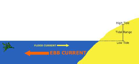
In the open ocean, tidal currents are relatively weak. Closer to shoreline and land, estuary entrances, narrow straits, and inlets, the speed of tidal currents can reach up to several kilometers per hour. Most coastal areas in the world experience 2 Low Tides and 2 High Tides every lunar day or for 24 hours. A Lunar day is the time it takes for a specific site on the Earth to rotate from an exact point under the moon to the same point under the moon.
A Lunar day takes 24 hours and 50 minutes. The lunar day is 50 minutes longer than a Solar day because the moon revolves around the Earth in the same direction that the Earth rotates around its axis. So, it takes the Earth an extra 50 minutes to “catch up” to the moon.
Unlike a Solar day, which is the time that it takes for a specific site on the Earth to rotate from an exact point under the sun to the same point under the sun. High tides occur 12 hours and 25 minutes apart, taking six hours and 12.5 minutes for the water at the shore to go from high to low, and then from low to high
The gravitational attraction between the Earth and the Moon is strongest on the side of the Earth that happens to be facing the moon, simply because it is closer. This attraction causes the water on this near side of Earth to be pulled toward the moon. The moon’s gravitational pull that happens here on the earth is strong enough to tug the oceans into a bulge.
As gravitational force acts to draw the water closer to the moon, inertia attempts to keep the water in place. But the gravitational force exceeds it and the water is pulled toward the moon, causing this Bulge of water on the earth’s surface.
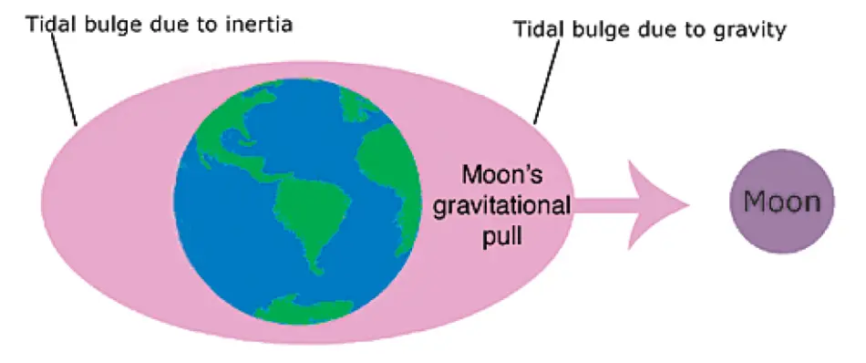
Another force called inertia which is the tendency of a moving object to keep moving affects the earth’s oceans too. As the moon circles the earth, the earth moves in a very slight circle too, and this movement is enough to cause a centrifugal force on the oceans. It’s a centrifugal force that holds water in a bucket when you swing the bucket in an overhead arc.
During full or new moons—which occur when the Earth, sun, and moon are nearly in alignment average tidal ranges are slightly larger. This occurs twice each month. The moon appears new (dark) when it is directly between the Earth and the sun.
The moon appears full when the Earth is between the moon and the sun. In both cases, the gravitational pull of the sun is “added” to the gravitational pull of the moon on Earth, causing the oceans to bulge a bit more than usual. This means that high tides are a little higher and low tides are a little lower than average. The King Tides are no more than the very highest tides that occur at each place.
King Tides Schedule
- Occur naturally and regularly
- Are predictable and expected events
- Are not an everyday occurrence.
King Tides
Are part of the normal and are a natural part of the tidal cycles. They are not formed by Global Warming or Climate Change. They are important though to open a window view for researchers to see what rising sea levels will look like down the road. The actual height reached by a king tide will depend on the local weather and ocean conditions on the day.
Using information from data collected by NASA, Oceanographers can see a rise in Sea levels of as much as 3 millimeters a year and can predict what the future will hold as the ocean warms. Using King Tides they can physically see locations along coastal regions where the most damage will occur on top of the rising sea levels by tracking it on Earth and from space.
The King Tide Happens when the moon is full or new and closest to the Earth.
The height of the tides also changes throughout the moon’s 28-day orbit around Earth. Every 14 days, the moon and the sun line up with Earth. Their combined gravity tugs on the oceans more strongly, making high tides even higher. These tides, which occur on the new and full moons, are called Spring Tides (spring as in “to spring up,” not spring-like season).
Spring tides
Occur twice a month, but some are higher than others. The moon’s gravitational pull is stronger when the moon is closer. So spring tides that occur when the moon is as close to Earth as it gets are higher than regular spring tides.
The very highest tides of the year are called the King Tides the spring tides are in late fall through early winter in the Northern Hemisphere when Earth is as close to the sun as it gets for the year.
High Tide Flooding
As sea levels continue to rise it no longer takes hurricanes and tropical storms to cause coastal area flooding. Flooding now occurs with high tides in many shoreline communities due to climate-related sea-level rise, land subsidence, and the loss of natural barriers along the shore. Especially with the onslaught of King Tides making it worse.
High tide flooding has seen more and more closing roads, overwhelmed storm drains compromising buildings along coastal highways in towns and cities. As the problems with rising sea levels get worse so do the effects of high tide flooding in the next couple of decades.
Scientist predicts that in this century problems like these will only get worse and have a huge impact over time decreasing the time between flood events. Because the oceans are liquid, the warmer they become the more they expand. Then the sea level rises. Just like the mercury in a thermometer. The warmer the mercury the more it rises up the glass column.
Then there is the additional mass in the oceans. The sources of this additional mass are melting glaciers from places like Alaska and the Himalayas. These Glacier’s runoff adds to the oceans causing the sea levels to rise. Greenland and Antarctica are also contributing to the worldwide problem. The rise in sea level is not uniform and happens more in the Western Pacific and at a smaller rise in the Eastern Pacific.
Sea level is measured by Tide Gauges around the coastal areas and by Satellite Altimeters that revolve around the earth. The Altimeter uses a radar pulse that travels from the Sattelite to the ocean surface and bounces back up to the Sattelite. The measurements are then worked out globally working with NASA using their Satellites to estimate worldwide Sea Level changes.
Land along the East Atlantic and West and Gulf coast are susceptible to high tide floods on sunny days and are becoming more and more normal. HTF is often referred to as ‘nuisance’ or ‘sunny-day’ flooding. Mapped by NOAA and is substantial, more than 2,700 square miles or slightly larger than the State of Delaware.
HTF events, made worse by Rising Sea Levels, are contributing to overwash and beach erosion, vacation rentals overwhelming storm/waste/freshwater systems, disrupting harbor operations, closing
roadways, and degrading subsurface infrastructure and property values.
NOAA predicts that this type of sunny flooding will occur twice as much by the year 2020 as it did in the year 2000. Cities like Miami will have to spend hundreds of millions to try and deal with it in the next few years. By the year 2030, they predict that on average the country will experience 7-15 days of high tide flooding and 25-75 days by 2050.
But because sea level rise isn’t evenly distributed along the coast, some locations in the coastline area will actually see a significantly higher number of HLF days than the national average. NOAA Tide Predictions are available online and printed in newspapers anywhere the tides matter.
Longshore Drift, a geological process caused by currents & wave action moving at angles towards the shore carrying sediments like sand parallel to the shoreline is dependent on the prevailing incoming wind direction. Current & sediment movement occurs in the surf zone & is also called Beach Drift ……………………………………………………………………….. Read more
Perigean Spring Tides
Knowledge of tides has always been important to people who look to the sea for their livelihood. Commercial and recreational fishermen use their knowledge of tides and tidal currents to help them improve their catches. Most people fish with incoming and outgoing high tides. Depending on the species and water depth in a particular area, fish may concentrate during ebb or flood tidal currents. The information is important to Boaters, Surfers, and even beachgoers.
Port information on tidal water is needed for getting ships and barges in and out of Ports. The water’s depth changes dramatically with incoming and outgoing tides. The depths and widths of the channels where big ships travel and the increased boat traffic leave very little room for error.
Real-time water level, water current, and weather measurement systems now are being used in many major ports and shipyards to provide mariners and port operators with the latest conditions. Besides Tidal water size and depth, tides also can affect the ecology, and pollutants, from land, fish, and marine life that are caught up in currents.
They also move floating animals and plants from breeding areas in estuaries to deeper waters, catch up, and move into rivers, oceans, and bays. As the world, climate changes and sea level increases Tidal Currents can circulate and move marine life from the smallest to the largest changing environments over the course of time.
National Oceanic Atmospheric Administration releases seasonal high tide flooding bulletins showing when regions around the nation may experience higher than normal high tides. Bulletins are updated quarterly. High Tide Bulletins are sent out by NOAA that provide an updated Interactive Map Regional Map that you can get important information for your region of the country and the world.
The rising and falling of the sea is a phenomenon upon which we can always depend. Tides are the regular rise and fall of the sea surface caused by the gravitational pull of the moon and sun and their position relative to the earth. Some factors cause the tides to be higher than what is “normally” seen day today. This bulletin tells you when you may experience higher-than-normal high tides for the period of time between June and August 2019.
In my area or Region, the Mid-Atlantic near New Jersey High King Tides will happen:
- July 31 – August 3
- August 28 – September 2
The reason for these King Tides is because of:
- A perigean spring tide will be occurring. This is when the moon is either new or full and closest to earth. Higher than normal high tides and lower than normal low tides will occur.
- The mean sea level is typically higher due to changing weather patterns and increasing water temperatures.
What kind of impact might I expect from these higher than normal Tides:
Minor tidal flooding along the coast, in particular in low-lying areas.
- If a storm occurs at this time, increased levels of tidal flooding and coastal erosion may occur.
- Lower than-normal low tides will also occur.
Where might I find high flooding from this event:
- Coastal areas near the tide stations at Bergen Pt, NY; Sandy Hook, NY; Atlantic City, NJ; and Cape May, NJ have the greatest chance of seeing high tide flooding
Coming from New Jersey and losing my home in Hurricane Sandy in 2012 I can appreciate the new technology advancing every day to give warnings out to people of coastal communities on threats from the rising ocean. But if the sea levels are rising as fast as they say, forecasting storms won’t be the answer. Natural tides and Flood currents will be growing regardless of Hurricanes or Tropical Storms like Sandy.
It’s still nice to know that Folks are watching!
What is a Bioluminescent Ocean?
Bioluminescence Ocean is a phenomenon occurring when one-cell organisms called dinoflagellates are disturbed by ocean waves & movement produces a chemical reaction using compounds combined with oxygen to emit light used as a defense mechanism against predators & adding a blue-green glow to ..……………………………………………… Read more
![]()