
Even as the available supply of water dwindles in California, the state’s increasing demand from population and drought means water suppliers and water users must do all they can to squeeze the most use from each precious drop of water. Where Does California Get Its Water From?
93% of Californians rely on publicly supplied H2O:
- Surface-H2O that travels or gathers on the ground, rivers, streams, & lakes
- Groundwater-H2O pumped from the ground-H2O Wells
- Watersheds North of Sacramento from rain & snow
- Drainage Basins in Central Valley
- Colorado River
- Reuse/Recycled
- Desalinization
- Imported
The state of California moving into the 20th century decided to build thousands of miles of a complicated web of water reservoirs, dams, pipelines, aqueducts, and canals to ensure water to the lower southern end of the growing populated cities of the state.
Introduction:
Often hailed as the Golden State, California is a place of varied landscapes and climates that continually challenge how water is sourced and supplied. As the lifeblood for this prospering region, understanding the intricate workings of the California Water System, and its differing water sources is crucial. This article is dedicated to unearthing the foundational dynamics and distinct characteristics that shape California’s water supply, on a journey to answer the query: “Where does California get its water?”
Where Does California Get its Water From
Ninety-three percent of Californians rely on publicly supplied water to meet their domestic water needs. Eighty-two percent of the water supplied by public water districts for domestic and other uses come from rivers, lakes, reservoirs, and other surface water sources.
The quality of the water flowing into these sources is directly affected by the condition of the land in the surrounding watershed. Better quality water generally translates to lower filtration and treatment costs for the utilities who deliver water to homes and businesses. Despite the importance of watershed conditions for California’s drinking water supply, there is currently no comprehensive database that maps the full extent and condition of those watersheds.
California’s water supply system, known as the State Water Project, is a complex network that supports this vast state. It’s a marvel of water management, ensuring that California’s water resources are efficiently distributed.
The system leans heavily on the surface water from the watersheds north of Sacramento, and the Colorado river water, serving as key water resources. River water gathered from these locations undergoes strict water quality checks before its delivered, through a series of pumps and aqueducts, to the areas that need it the most.
Los Angeles, for instance, being a part of Southern California, relies heavily on imported water. This region redirects water from state water project aqueducts and the Colorado river. This imported water is a major source of drinking water, supplemented by localized water supply, groundwater and in some cases, recycled water.
In contrast, the Delta region is home to some of the densest and most productive underground aquifers. Their water is primarily sourced from this groundwater, in addition to a portion of state water supplied from the state water project. This regional water supply supports a substantial portion of California’s population.
California’s water supply system is more than just a massive project. It’s a billion-dollar investment, a life source, and a bond that connects the disparate parts of California, highlighting the importance of water management on both a regional and a state level. It shows how California’s varying water needs and their ability to meet them have shaped the state as we know it.
| S.No | Source of Water | Description |
|---|---|---|
| 1 | Precipitation | Most of California’s annual water supplies come naturally from the weather precipitation in the form of rain and snow. |
| 2 | Surface Water | The state has an extensive system of reservoirs and thousands of miles of canals and pipes to move and store water. This does not include water that soaks into the ground to replenish aquifers in California’s groundwater basins. |
| 3 | Groundwater | Groundwater provides about 30 to 46 percent of the state’s total water supply and serves as a critical buffer against drought and climate change. |
| 4 | Recycled Water | Recycled water helps stretch California’s water supplies. It is generated from sewage and other wastewater treated at water recycling facilities. |
| 5 | Desalinated Water | Desalinated water, removing salt and other impurities from seawater, can provide a drought-proof supply but it is generally more expensive compared to other water supply sources. |
| 6 | Imported Water | Large mass of California’s water supply is imported from other regions via an extensive network of man-made aqueducts. |
Where Does Northern California Get Its Water
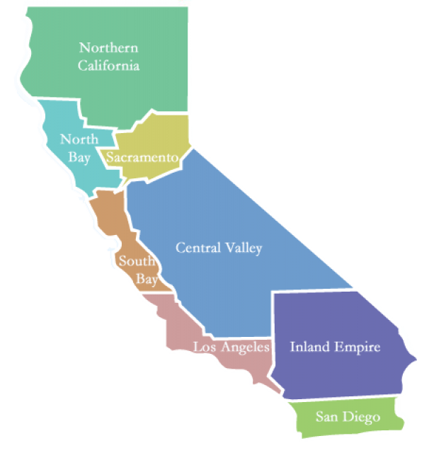
Northern California’s main supply of water around 75% where only 20% of California’s population resides comes from surface water and is replenished by precipitation in the form of rain or snow that melts in the spring. This is because most of the state’s precipitation occurs in the northern 1/3 of the state, above the city of Sacramento averaging 100 inches or more a year, where we find 75 percent of the available water.
Westerly winds bring in moisture from the Pacific Ocean where they impact northern California’s high mountain ranges. The air rises mixes with colder air moving down from the Pacific Northwest and cools turning to precipitation.
Northwestern California sees 2x as much rain as London England gets in a year. This heavy precipitation moves south into the very northern parts of the Central Valley.
In order to move a supply of water from the wetter north to the drier south 2 main components were developed called Central Valley Project and the California State Water Project.
Using much-needed water for irrigation for farming in the Central Valley and for the growing population in cities like Los Angeles and San Diego inhabiting the southern end of the state. Reservoirs like Lake Shasta and Lake Oroville are seeing all-time lows but not to the levels seen in the Central and South.
Where Does Central California Get Its Water
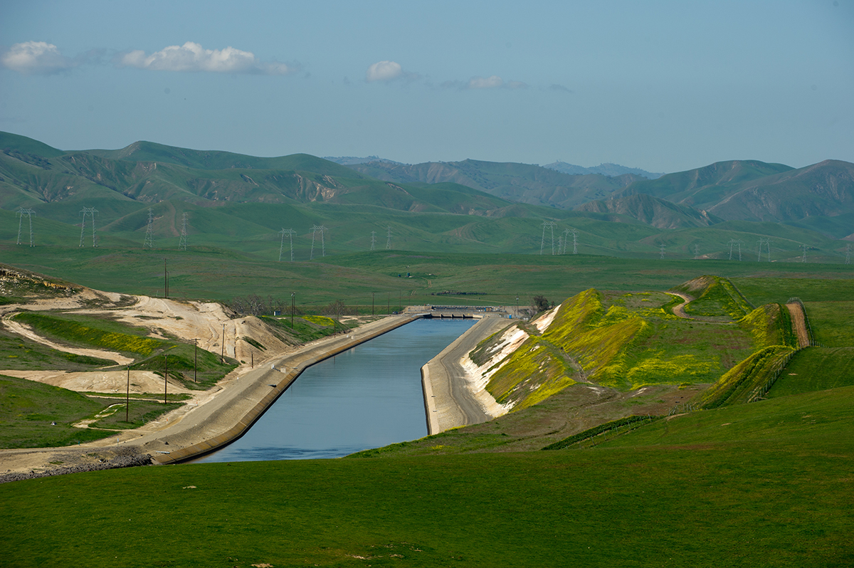
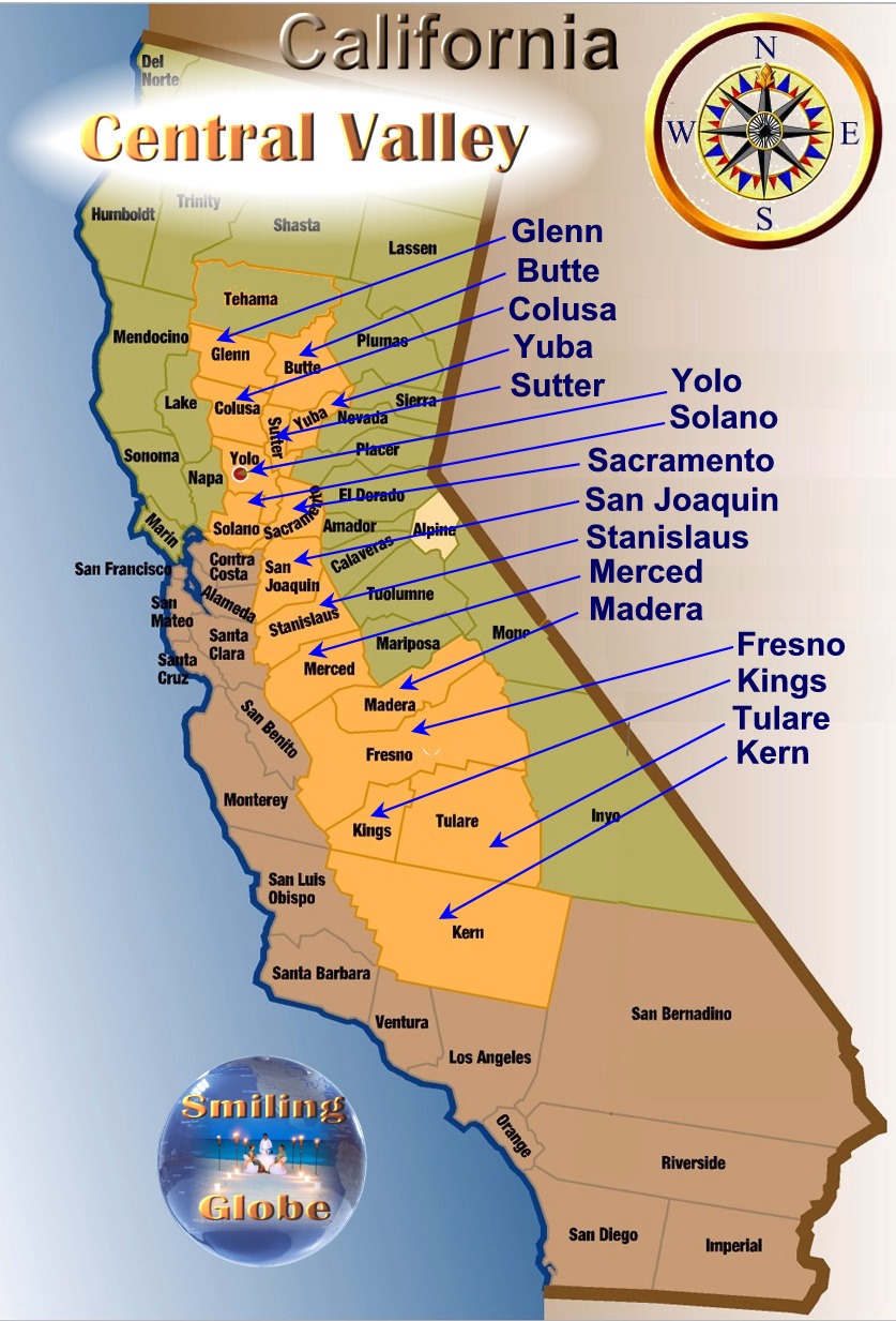 Moving south is the Central Valley a vast agricultural region of California that covers about 20,000 square miles and is one of the more notable structural depressions in the world.
The Central area is bounded by the Cascade Range to the north, the Sierra Nevada to the east, the Tehachapi Mountains to the south, and the Coast Ranges with San Francisco Bay to the west.
The conveyance of water moving north to south relies on the movement of that water through the Delta and its maze of levees and islands while maintaining the right balance of saltwater and fresh water.
These mountain ranges surrounding the area North of Central Valley all have thick snow base in the winter that melts in the spring and summer months that fill California rivers and streams like the Sacramento and San Joaquin rivers providing much-needed water. They supply water to the Sacramento-San Joaquin Delta, a water source that serves roughly 25 million Californians via the State Water Project.
The northern one-third is known as the Sacramento Valley and the southern two-thirds is known as the San Joaquin Valley. About 75% of the irrigated land in California and 17% of the Nation’s irrigated land is in the California Central Valley. About 20% of the state’s groundwater demand is supplied from pumping Central Valley aquifers, making it the second-most-pumped aquifer system in the U.S.
The Sacramento-San Joaquin Delta is the hub of California’s water supply, supplying fresh water to two-thirds of the state’s population and millions of acres of farmland.
Saltwater from the San Francisco Bay mixes with fresh water from the Sacramento, San Joaquin, and other rivers to create the largest estuary on the West Coast. Groundwater accounts for about 30% of the annual supply of both types of water used for agricultural and urban purposes.
Where Does Southern California Get Its Water
Moving south of the Central Valley lies the Southern region of California which holds 80% of the population but only produces around 20% of the state’s supply of water. This means that a large portion of water that is produced in the Northern end of California is pumped down into the dry arid regions of southern California to meet their much larger demand.
Here lies the most critical problem that contributes to the California water crisis. Around 200 million acre/ft. of water will fall on California annually from rain snow and water imported elsewhere.
- Half of this amount is consumed by nature in evaporation or drains into the Pacific Ocean.
- Half is consumed by humans and agriculture or 100 million acres.
An acre-foot of water equals about 326,000 gallons or enough water to cover an acre of land which is (the size of a football field 1 foot deep). An acre-foot of water is a common way to measure water volume and use especially in the western part of the US where water is measured daily.
Unfortunately, these numbers fluctuate to up to 40% and are dependent on variables like wet months between December and February in the northern end, snow melt in Sierras Nevadas, and the Cascades mountains and what scientists call the Mega Drought in the country’s southwest. The drought lasting now 22 years has put tremendous stress on all sources of water feeding numerous states in the southwest region of the US.
Does California Get Water From the Colorado River
Yes, via the Colorado River Aqueduct is a 242 mi water conveyance in Southern California in the United States, operated by the Metropolitan Water District of Southern California (MWD). The aqueduct takes water from the Colorado River at Lake Havasu on the California-Arizona border, west across the Mojave and Colorado deserts to the east side of the Santa Ana Mountains. It is one of the primary sources of drinking water for Southern California.
The Metropolitan Water District of Southern California is the largest supplier of treated water in the United States. It is a cooperative between fourteen cities, eleven municipal water districts, and one county water authority, providing water to 19 million people in a 5,200-square-mile service area. It was created by an act of the California Legislature in 1928, primarily to build and operate the Colorado River Aqueduct.
Will California run out of Water?
Yes, California will run out of water within 1 year, says, Jay Famiglietti, a NASA senior Water Scientist at the Jet Propulsion Laboratory. Data reveals that total H2O storage in Ca. has been declining since 2002 when satellite-based monitoring began, & groundwater depleting since the early 20th ……………………………………………………………. Read more
Who Uses the Most Water Supply in California
Water in California is shared across three main sectors. Statewide, average water use is roughly
- 50% environmental
- 40% agricultural
- 10% urban although the percentage of water use by areas changes dramatically across regions and between wet and dry years.
Water that is used for environmental causes falls into four categories:
- river water is protected as “wild and scenic” under federal and state laws
- water is required for maintaining habitat within streams
- water that supports wetlands within wildlife preserves
- water needed to maintain water quality for agricultural and urban use
Water rights in California are complex and diverse, and ownership is distributed among various entities. The state’s water resources are typically managed by a combination of public agencies, private entities, and individuals.
The largest water supplier in California is the state itself, through agencies like the California Department of Water Resources and the State Water Resources Control Board. Additionally, numerous local water districts, cities, and private water companies also hold water rights. The distribution and management of water resources involve a combination of public and private ownership, making it a complex system with multiple stakeholders.
Water ownership in California is distributed among various entities, and it’s challenging to provide an exhaustive list due to the complexity of water rights and the numerous organizations involved. However, here are some key entities that play significant roles in managing and supplying water in the state:
- California Department of Water Resources (DWR): A state agency responsible for managing and protecting California’s water resources, including overseeing the State Water Project.
- State Water Resources Control Board (SWRCB): The SWRCB is responsible for allocating and protecting water resources in California. It plays a regulatory role in water rights.
- Metropolitan Water District of Southern California (MWD): One of the largest water suppliers in the state, providing water to Southern California. It imports water from the Colorado River and Northern California.
- Bureau of Reclamation: A federal agency that manages water resources in the Western United States, including the Central Valley Project, a major water storage and conveyance system in California.
- Local Water Districts: Numerous local water districts, such as the Westlands Water District and the Kern County Water Agency, play vital roles in managing water resources for agriculture.
- Individual Farmers and Agricultural Entities: Many individual farmers and agricultural corporations hold water rights for irrigation purposes.
It’s important to note that water rights and ownership can be highly localized and depend on specific regions, watersheds, and the type of water use (agricultural, municipal, industrial). The information provided here gives a broad overview, but the details can vary significantly based on the specific water source and its management.
California State Water Sources Map
 California’s dependency is based on two sources of its water: surface water and groundwater. It’s so important that California monitors groundwater and surface water throughout the state.
The water that runs into rivers, lakes, and reservoirs is called “surface water.” Groundwater is found beneath the earth’s surface in the pores and spaces between rocks and soil. These are called aquifers. Groundwater supplies and wells are collected and water quality is monitored by the state.
Most of California’s precipitation falls as snow in the northern part of the state in the watersheds north of Sacramento during the winter. The snow acts as a natural reservoir, storing water until the spring runoff. After initial evaporation, percolation into the ground, and transpiration
the water flows into streams and rivers and makes its way toward the ocean or down into salt sinks. Their water is counted as natural underground Aquifers on a current water source database for the state of California and is measured as Groundwater is monitored on a state-live interactive site.
The South Bay Aqueduct is an aqueduct located in the eastern part of the San Francisco Bay Area. It conveys water from the Sacramento-San Joaquin Delta through over forty miles of pipelines and canals. It is overseen by the state of California Regional Water Management.
The aqueduct flows along the eastern and southern edges of the Livermore Valley. Then it flows through a series of tunnels to an end in the foothills of eastern San Jose, 5 miles from downtown San Jose, California.
Meets Southern California and the Colorado Aqueduct that’s supplied from the Colorado River which can be thought of as a man-made river is capable of transporting up to 1 billion gallons of water daily to Southern California’s urban regions, according to the Bureau of Reclamation.
Conclusion:
In conclusion, California’s water supply is a complex system stemming from a variety of sources including groundwater, surface water from lakes, rivers, and reservoirs, and imported water. Understanding the California Water System is essential to appreciate the challenges and advancements in efforts toward securing clean and sustainable water in the face of climate change and population growth. As the state continues to adapt to changing environmental realities, a critical awareness of this vital resource will undoubtedly become even more valuable.
What Type of Water Rights are in California?
In California, water rights are based on a hybrid mixture of riparian & appropriative rights issued & managed by the state & federal government to benefit all Californians giving individuals & others the right to beneficially use underground & surface water subject to seasonal & drought ……………………………………………………………………… Read more
![]()
References:
USGS– California Central Valley
California Dept. of Water Resources- The Delta
FAQ’s
Q: Where does California get its water from?
A: California gets its water from a variety of sources such as surface water from north of Sacramento watersheds, the Colorado River, groundwater, and in some cases, recycled water.
Q: What is the state water project?
A: The state water project is a complex water supply network in California that ensures efficient distribution of water resources across the state.
Q: How is the water quality ensured?
A: Water quality is ensured through strict water quality checks before it’s delivered to different areas via a series of pumps and aqueducts.
Q: How does Los Angeles sourced its water?
A: Los Angeles, being a part of Southern California, relies heavily on imported water which is redirected from the state water project’s aqueducts and the Colorado River. This is supplemented by localized water supply, groundwater, and in most cases, recycled water.
Q: What is the importance of the Colorado River and the Delta in California’s water supply?
A: The Colorado River and the Delta are pivotal parts of California’s water supply. They contribute to nearly 60% of the state’s water needs, supporting its agricultural, metropolitan, and industrial regions. Therefore, understanding these systems is crucial in managing California’s water needs.
")
