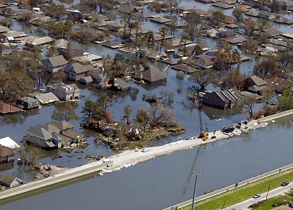
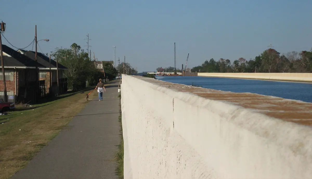
In 2005, New Orleans made international news when Hurricane Katrina breached its levees. Much of the city lies 10 feet (3 meters) below sea level. What is a River Levee?
A river levee is an embankment designed to prevent river flooding by confining water within the channel. Typically made of earth or reinforced materials, river levees protect surrounding areas from inundation during high water flow, serving as vital flood control infrastructure.
Levees are usually made of earth. The natural movement of a body of water pushes sediment to the side, creating a natural levee. The banks of a river are often slightly elevated from the riverbed.
Introduction:
Levees are essential structures for managing water flow in places prone to flooding, yet many are unfamiliar with their function and design. While the term ‘levee’ may sound complex, it is fundamentally a simple, human-made structure with a critical role. This article will explain the world of river levees, their importance, their structures, and their purpose. By the end of your read, you’ll have a solid understanding of what a river levee is and why it plays such a crucial part in landscape, environmental, and urban planning.
What is a River Levee: Understanding Levees
A Natural levee usually looks like a small hill or slope that rises from the bank of a river or other body of water. They can differ widely in size depending on their age, their place alongside the body of water, and the size of the body of water. Levees can also be artificially created or reinforced. Artificial levees are usually built by piling soil, sand, or rocks on a clear. They play a crucial role in managing water levels and safeguarding communities and agricultural land from the adverse impacts of flooding. Artificial levees prevent flooding but they also create a new problem: levees squeeze the flow of the river. All the river’s power is flowing through a smaller space.
Understanding the Levee System and its Function in Rivers
Understanding the basic workings of a levee system is fundamental to appreciating its vital role in flood management. Essentially, a levee is a physical barrier whose primary function is to reduce the risk of flooding. It’s simply a man-made embankment built along riverbanks to resist the force of water. A levee is a guard standing steadfast against the relentless onslaught of river currents. This barrier, both simple yet complex in its construction and purpose, is at the heart of controlling and managing water forces around the world.
Artificial levees come into the picture where natural buffers fail, creating an additional line of defense. The relentless waters of rivers, etching their way into the landscape, imprint a pattern that is beautiful, and dynamic, but inherently destructive. It’s not just about the riverbanks but managing the forces of H2O requires a broader understanding and a keen eye on the delicate balance between man, nature, and water.
Rivers are not just about water; they carry sediment, debris, and life. They shape landscapes and civilizations. Understanding their power and respecting their course is integral to the functioning of the levee system. The alternative could be a natural disaster in places that are susceptible around the world.
The unending repetition of the word “levee” itself underlines the gravity and consistency of its purpose and its presence across landscapes. It’s not just a levee but a group of levees, each contributing in its unique way to manage the water force. The main purpose is to prevent flooding. But their strategic positioning, considered design, and structured coordination make each levee’s role engineered specifically for the area it’s guarding.
Every time a river floods its banks, a levee stands guard. Addressing floods or rather, preventing them, is why they are built at all. As such, it’s crucial to underscore the recurrent and cyclic nature of flooding and the consistency of efforts to control it. They also have numerous other jobs:
- Containment: Levees act as barriers along riverbanks to contain and control the flow of water within the river channel.
- Flood Protection: The primary function is to prevent or mitigate flooding, safeguarding nearby communities, farmland, and infrastructure.
- Embankment Construction: Levees are constructed using materials like earth or reinforced with concrete to create a stable embankment.
- Height and Slope: Levees are built with specific height and slope considerations to effectively contain water without causing erosion or instability.
- River Management: They play a crucial role in managing water levels, preventing overflow, and directing water flow to designated channels.
- Erosion Control: Levees help control erosion by stabilizing the riverbanks and preventing soil loss during periods of high water velocity.
- Infrastructure Protection: Critical infrastructure such as roads, bridges, and utilities benefit from levees as they shield these assets from destructive floodwaters.
- Vegetation: Some levees incorporate vegetation for added stability and environmental benefits, such as habitat preservation.
- Emergency Preparedness: Levees contribute to emergency preparedness by reducing the risk of sudden, catastrophic flooding events.
- Maintenance: Regular inspection and maintenance are essential to ensure the ongoing effectiveness of levee systems in protecting against floods.
In understanding a levee system, it’s essential to remember the primary function of a levee – to be a physical barrier whose sole purpose is to reduce the risk of flooding. It’s simply a man-made embankment built to tame the rivers. And it’s a testament to human ingenuity, our constant striving to assert control over nature’s forces, over the water trying to flood our banks. Every levee system securing a river, like in New Orleans needs to stand the test of time because Levee failure is not an option.
The Inevitability of Levee Breaks: Analyzing How and Why Levees Fail
Understanding the inevitability of a levee break means recognizing how these protective levees often fail. The science behind it can provide valuable feedback and insight into the forces and factors that contribute to its failure. Despite the engineering prowess invested in designing a levee system, incidents of failures are still quite rampant, begging the question: “Why do levees fail?”

Overtopping is another major reason why levees fail. Even the best-engineered levee systems can be overwhelmed by a flood that’s bigger than what the system was designed to handle.
For instance, if the river’s water level surges above the top of the levee, it’s an overtopping situation. Such scenarios can cause considerable damage, eventually eroding the levee and possibly leading to a catastrophic levee break.
Seepage refers to the process where water permeates the levee body and emerges on the protected side. This process can substantially weaken the structure over time and result in levee failure. This issue often arises in inadequately designed or maintained levees in areas prone to significant rainfall or flooding. Therefore, addressing seepage can help prevent many levee breaks.
Among these, another area demanding our attention is the need for constant monitoring and maintenance of the levees. Over the years, many levees have failed due to tardiness or infrequent maintenance causing these stronghold walls to lose their protective ability. A lack of public interest and funding often hampers effective maintenance schedules, hence leading to a higher potential for levee breaks.
Understanding this, the engineering sector is continuously working to mitigate these limitations. Substantial efforts are being directed toward the development and refinement of advanced models that can simulate conditions more accurately, thus improving our ability to predict and prevent such failures. However, the effectiveness of such approaches will be heavily influenced by our ability to comprehend and modify the engineering designs of our contemporary levee systems. As the adage goes, ‘prevention is better than cure’ and it’s a strategy to subscribe to for managing and ultimately preventing levee failures.
Natural Levees vs Engineered Levees: An Exploration of Water Control Measures
The comparison between natural levees and engineered levees delves into the heart of our efforts to control water. It’s about designing systems that manage flooding potential in our land and sea areas in a way that’s sustainable and effective. Whether it’s a levee protecting the city of New Orleans from hurricane threats, or the strong river levees outlined along the Mississippi, understanding where these two types differ is crucial.

Looking at the top river levees in history, natural levees are formed from water-borne sediments deposited by floods. This process forms earthen embankments along the river’s edge over time. Floods play a defining role in shaping lands and areas around rivers. Whereas the Mississippi’s natural levees have been shaped by countless floods and the flow of water, in California, lands formed by natural levees are also popular.
Engineered levees, on the other hand, are a masterpiece of technology. Each levee is a product of precise levee design, incorporating the lessons we’ve learned from past floods into each construction. In protecting extensive land and sea areas, the value of these levees is immeasurable.
The levees found in New Orleans are a testament to this, offering a system of both protection and control against hurricanes and floods. Indeed, after the heartbreak wrought by Hurricane Katrina, Levee’s design has been an article of intense discussion.
The levees in the city do more than protect the land – they preserve the life and history within. This is the function of our levee system – not simply to hold back water, but to safeguard the areas we call home. Natural levees and engineered levees each have their strengths and weaknesses, their purposes and points of inflection. Yet in both instances, their importance to both the safety and shape of our cities is clear.
Understanding these levees isn’t just about understanding how we protect against hurricane threats, or how we control the flow of a river. It’s about comprehending how we’ve learned from the history of each flood, how we’ve used technology and innovation to enhance levee design, and how that has improved the system of protection across different areas.
It’s also understanding that each levee, from natural levees along the Mississippi to the engineered levees of California and New Orleans, tells a story. A tale of endurance, adaptation, failure, recovery, and ultimately, resilience, against the unstoppable forces of nature.
Conclusion:
In conclusion, understanding what a river levee is illuminates its importance in flood control and land protection. These man-made structures have a significant impact on directing river water flow to prevent disastrous flooding and maintain fertile farming lands. Continual inspection and maintenance of levees are vital for their optimal function. It’s a complex task, calling on top-notch engineering practices, appreciating the natural attributes of the river, and acknowledging the potential environmental impacts. Truly, while they may just be embankments to some, river levees play a decisive role in our coexistence with nature.

References:
National Geographic-Levee-Living near water is a wonderful thing—except when there’s a flood
How Stuff Works-What is a Levee?
History-How Levee Failures Made Hurricane Katrina a Bigger Disaster
FAQ’s
Q: What is a river levee and what’s its function?
A: A river levee is a human-made structure, essentially a physical barrier, built along riverbanks with the primary function of reducing the risk of flooding. It helps in managing water forces and is critical in landscape, environmental, and urban planning.
Q: How does a levee system work?
A: A levee system works as a barrier against river currents, reducing the risk of flooding. They come into the picture when natural buffers fail, thus creating an additional line of defense against the forces of nature. They are strategically positioned, and their design and coordination make each levee part of a comprehensive whole.
Q: Why is constant monitoring and maintenance of levees necessary?
A: Constant monitoring and maintenance of levees are necessary to prevent failures that can lead to flooding. Many levees fail due to inadequate maintenance which can cause them to lose their protective ability. Lack of public interest and funding often hamper effective maintenance schedules, thus increasing the potential for levee breaks.
Q: What is the difference between natural and engineered levees?
A: Natural levees are formed from water-borne sediments deposited by floods, forming earthen embankments over time. Engineered levees are precisely designed and built, incorporating lessons we’ve learned from past floods, and are aimed at protecting extensive land and sea areas from flooding.
Q: Why do levees fail and what contributes to its failure?
A: Levees can fail due to geotechnical failure, overtopping, or seepage. Geotechnical failures often occur when the levees are burdened beyond their capacity. Overtopping occurs when a flood is bigger than what the system was designed to handle. Seepage, where water permeates the levee and weakens it, often arises in inadequately designed or poorly maintained levees in flood-prone areas.
