The Mississippi watershed is the third-largest in the world and plays a key role in the environmental aspects of a major portion of the country, covering over 41% of the USA along with parts of two Canadian Provinces. Where does the Mississippi River begin and end?
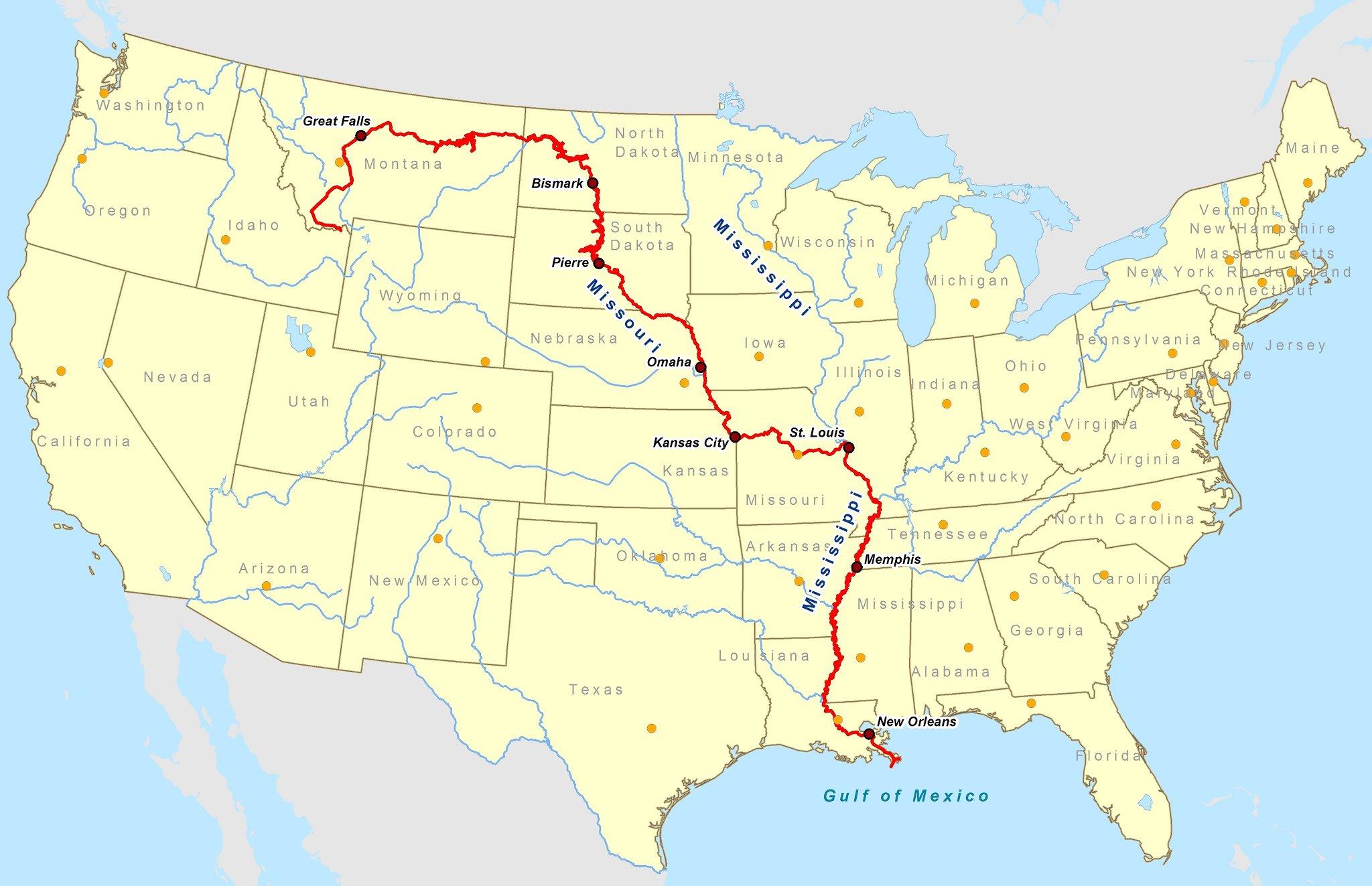
The Mississippi River begins as a tiny outlet stream from Lake Itasca in Northern Minnesota. Making its way on a 2,350-mile journey south joined by hundreds of tributaries draining 31 states, The Ohio & Missouri Rivers & ending at about 100 miles downstream of New Orleans in the Gulf of Mexico,
During a vacation that I once took with my family that included Nashville, Memphis, and New Orleans, I was introduced to the incredible views of the great Mississippi River that I had always read about but had never seen in person. It was a powerful site, the most notable American River that ties the north to the southern part of our nation. I was very cool indeed!
Introduction:
Celebrated in literature and songs, this grand body of water holds a treasure chest of American history, culture, and natural beauty. The majestic Mississippi River is often celebrated in literature and songs, this grand body of water holds a treasure chest of American history, culture, and natural beauty. But where does this monumental river start, and where does it end? From its humble beginnings in a small Minnesota lake to its dramatic end in the Gulf of Mexico this fascinating landmark and the stories tell the American story.
Where does the Mississippi River Begin and End
The Mississippi River is one of the longest rivers in the world, stretching approximately 2,340 miles (3,766 kilometers) from its source to its mouth.
Its journey begins at Lake Itasca in northern Minnesota, where it is just a small stream. From there, it flows southwards through the United States, passing through or along the borders of ten states: Minnesota, Wisconsin, Iowa, Illinois, Missouri, Kentucky, Tennessee, Arkansas, Mississippi, and Louisiana.
The river eventually empties into the Gulf of Mexico near the city of New Orleans, Louisiana, forming a vast delta region before merging with the sea. This delta is an important ecological area and a significant feature of the Mississippi River’s geography.
The Start of the Mississippi River: An Exploration of River Headwaters at Itasca State Park
The start of the Mississippi River is located in Itasca State Park. The lake’s depth usually varies between 6 and 11 meters and is at an elevation of 450 meters above sea level.
There have been a few controversies as to the exact source because of the numerous tributaries that flow all year long, feeding Lake Itasca, and the term ‘source’ has evolved over the years in the scientific community. In 1832, Henry Rowe Schoolcraft identified Lake Itasca as the source of the Mississippi River. At the primary source in Lake Itasca, the river is 20 to 30 feet wide. This is the narrowest width for its entire stretch.
The widest part of the Mississippi can be found at Lake Winnibigoshish near Bena, MN, where it is wider than 11 miles. The widest navigable section in the shipping channel of the Mississippi River is Lake Pepin, where the channel is approximately 2 miles wide.
Lake Pepin is the largest lake on the Mississippi River at 45 square miles and an average depth of 21 feet, located on the border of Wisconsin and Minnesota. At the Headwaters of the Mississippi River, the average speed of the surface water is 1.2 mph, or about i/2 the speed of how fast people walk.

Another way of measuring how big the river is can be calculated by the discharge of the river. Using this measurement, the Mississippi is the 15th largest river in the world, discharging (593,003 cubic feet) of water per second into the Gulf of Mexico. In comparison, Amazon discharges (7,380,765 cubic feet) per second.
The Watershed area can be used to measure the size of the River, that is, the area drained by a river and its tributaries. The Mississippi River drains an area of about 3.2 million square kilometers (1.2 million square miles), including all or parts of 31 states and two Canadian provinces, about 40% of the continental United States.
It’s the 4th largest in the world. It extends from the Allegheny Mountains East to The Rocky Mountains in the West. The Amazon for comparison drains about 7.1 million square kilometers (2.7 million square miles). Communities all up and down the Mississippi used the river for a drinking water supply and Industrial and Municipal Wastewater discharge.
The EPA says the 50 US cities rely on the Mississippi for their daily Drinking Water Supply. The Start of the Mississippi River in Lake Itasca in Northern Minnesota, where the Mississippi is born and cut through the center of the Country. The Mississippi River Basin Drains 31 states and travels through 10 states in the Country. It joins the Ohio and Missouri Rivers before ending in the Gulf of Mexico.
A History Lesson: Tracing the Mississippi River from Beginning to End
Spanning over 2348 miles in the United States, The Mississippi is the second-longest river in the country. But its 1250,000 square mile drainage area is ranked 3rd largest in the world. The waters from the Mississippi rise in Minnesota and run south, inevitably emptying into the Gulf Of Mexico. The first Europeans to see the river were the history of the Mississippi River.
In 1682, a Frenchman by the name of Robert de La Salle reached the mouth of the river and claimed it in the name of his country France. The Western portion was purchased in 1803 by the United States, resulting in the largest real estate transaction in human history. The Louisiana Purchase. After the Louisiana Purchase and with the development of the Steamboat, the Mississippi River became the most important vein for transportation in the New World. The Mississippi river flows would help forge the settlers in the central area of the US using the steamboat as the vehicle, making it happen.
In 1812 the Steamboat New Orleans reached the city it was named after a four-month voyage from Pittsburg, Pennsylvania. The trip was historically important for economic and cultural change. The voyage marked the beginning of commercial steam navigation on inland rivers and led to revolutionary economic and cultural change.
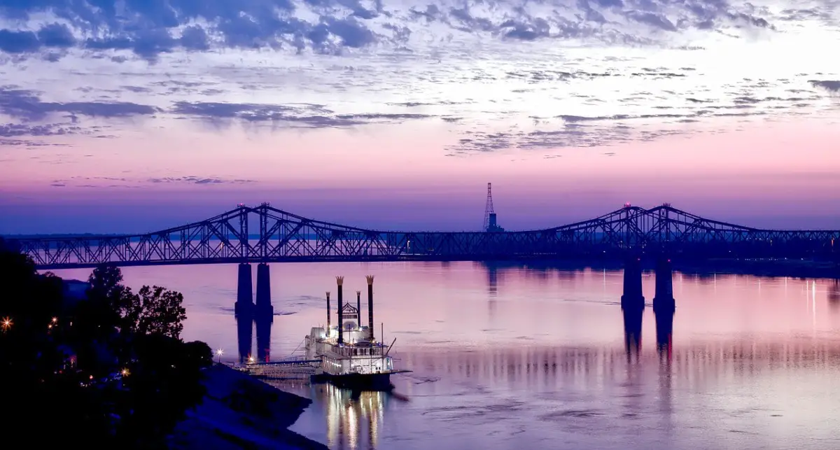
By 1860, more than 1000 steamboats will be on the river, all involved in transport, trade, and commerce. This will make cities like Cincinnati and Louisville important cities in the movement west because they are located near the river. The river eventually became a vital industry during the Civil War. Control of the waterway was a major strategic objective of the Union forces. The Port of New Orleans remains the 6th largest port in the US.
The Port of New Orleans alone serves as the 6th largest port in the United States, with the collective ports of South Louisiana boasting the 9th overall ranking in the world. The mighty Mississippi River played a big part in the development of our country. It was essential for the Industrial Revolution and has been altered and harnessed over time.
Through the efforts of dredging, dining, and federally funded levees and man’s attempt to control the river and reduce flooding, we continue to use the Mississippi to drain and rinse by damming and channeling the river through the country’s center.
Over the years, cutting off floodplains from the river, degrading habitat, and threatening the vast array of fish and wildlife that traditionally call the Mississippi River home.
The basin provides critical habitat for more than 300 candidate species of rare, threatened, or endangered plants and animals listed by state or federal agencies. Efforts started in 2014-2015 in the Upper Mississippi to reconnect some of the rivers with its natural flood plains.
Dam removal in Minneapolis and levee modifications will help restore lost habitat and improve the river’s function. The Federal Government has allocated funding of $31 million for the Upper Mississippi River Restoration Program.
The 3 Sections Of The Mississippi River
Upper Mississippi the river headwaters runs for 950 miles to the confluence with the Ohio River at Cairo, Illinois. The Upper Mississippi where the great Mississippi begins, is defined by a range of limestone bluffs that were carved by water from melting glaciers at the end of the last ice age.
As the glaciers melted, water stretched from bluff to bluff, forming a glacial-fluvial spillway (known as Glacial River Warren) that cut deeper and deeper into the landscape.
The bluffs are composed of layers of frail sandstone at the base and dolostone at the top, a form of limestone that doesn’t erode as easily. As the water washed away the lower layers of sandstone, chunks of the dolostone cleaved off, giving us the dramatic vertical bluff faces we see today along the upper river.
The Middle Mississippi- is relatively free-flowing. From St. Louis to the Ohio River confluence, the Middle Mississippi falls 220 feet (67 m) over 180 miles (290 km) for an average rate of 1.2 feet per mile (23 cm/km). The Missouri River will travel more than 2,300 miles before it joins the Mississippi in its namesake state at St. Louis
At its confluence with the Ohio River, and Missouri River the Middle Mississippi is 315 feet (96 m) above sea level. Apart from the Missouri and Meramec Rivers of Missouri and the Kaskasi of Illinois, no major tributaries enter the Middle Mississippi River.
The Lower Mississippi- is called the Lower Mississippi River from its confluence with the Ohio River to its mouth at the Gulf of Mexico, a distance of about 1,000 miles.
Much of the Lower Mississippi River is bound by levees, floodwalls, and control structures as part of the Mississippi River & Tributaries (MR&T) project, a comprehensive, multi-state flood damage risk management program for the lower alluvial valley.
This broad, rich valley reaches from southern Illinois to the southeastern tip of Louisiana, covers more than 90,000 miles of rivers and streams, more than 3 million acres of land, and dictates much of the region’s landscape and land use.
The Delta forms the most important bird and waterfowl migration corridor on the continent and supports North America’s largest wetland area and bottomland hardwood forest.
Using the streamflow data, NASA’s Horace Mitchell traced the path of all the water that runs into the Gulf of Mexico via the Mississippi River. The video starts at the furthest point away from the Mississippi’s outlet and then moves down hundreds of streams and rivers toward the delta. The Mississippi River is more than 2300 miles long and is ranked 4th behind the Amazon, Nile, and Yangtze Rivers.
Where does the Missouri River Begin and End?
The Missouri River a tributary of the Mississippi begins in Three Forks, Montana, as the confluence of 3 major rivers, Madison, Jefferson & Gallatin & ends in St. Louis, Missouri. Crossing South Dakota, North Dakota, Nebraska, Iowa, Colorado, and Kansas, .………………………………………………………………. Read more
The Mississippi River Delta Blues
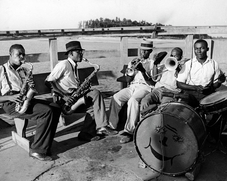
Mississippi Delta Blues was one of the earliest forms of Blues music that was formed in the Mississippi Delta, which is a region of the US that lies between Memphis, Tennessee in the north to Vicksburg, Mississippi, in the south and from Helena, Arkansas in the west to the Yazoo River in the east.

Music and the lower Mississippi River Delta are synonymous, and, indeed, the Delta is what some people refer to as the cradle of American music. Musical styles within the Delta region are diverse, and it was here that the blues, Cajun music, jazz, and zydeco evolved. Yet best known around the world is the blues music of the lower Mississippi River Delta.
The Mississippi Delta is famous for its fertile soil and for its poverty. Delta blues is regarded as a regional variant of Country Blues Guitar and harmonica is its dominant instrument; the slide guitar is a hallmark of the style. Vocal styles in Delta blues range from introspective and soulful to passionate and fiery.
Musical styles within the Delta region are diverse, and it was here that the blues, Cajun music, jazz, and zydeco evolved. Yet best known around the world is the blues music of the lower Mississippi River Delta. It was deeply rooted in African-American Culture and the struggle of their time.
The music was used before the turn of the century. It wasn’t recorded until after 1920. Major Record Labels recorded the earliest recordings, usually one person on an acoustic guitar. Some important names were Son House, Robert Johnson, and Muddy Waters, to name a few.
The notoriety of Blues Music has grown over the years in cities located in the Lower Mississippi, like the Mississippi Heritage Foundation in Greenville, MS, and festivals in countries all around the world. But other types of Americana Roots music are attributed to the Mississippi River.
The genre is hard to nail down, but you know it when you hear it. Mississippi Music is defined by Geography Memphis, St. Louis, and New Orleans, all of which have their own specific styles of music. Mississippi Music is a wide source of music that is influenced by musicians, poets, and writers who migrate to other parts of the world and carry the source of culture that comes from the region that the river carries.
They’re more to Mississippi Music than the Blues, and it has been the source of Country Blues and Folk music for many years. The 3 parts of the River have populations that started on the Lower Mississippi and ended up on the Upper part in St. Louis or other cities.
The results end up being a mixture of genres like rockabilly and rhythm and blues, sometimes you have jazz players, and sometimes you have rock and rollers like Chuck Berry. So you do get people who migrate down and upriver. Downriver, New Orleans is the source of so much jazz, and of course, afterward soul, R&B, funk, the works of Fats Domino, the Meters, the Neville Brothers, plus many who continue with traditional jazz.
Up River into the Twin Cities with Dylan or Prince’s interpretation. You can work on Art, Food, and earlier Cultural Architecture in the parts of the Mississippi River too. All add into a melting pot by traveling up and down the Mississippi. In earlier times even used the river for transportation to do so.
Country Blues and Ragtime string band music with a strong influence of western swing, 20’s jazz, and all those sweet ’20s/30’s types of diverse influences.
Musicians moved from New Orleans up to Chicago to make money, never staying too long in one place, which gave Blues music an adaptation in each part of the Country. Same genre with different adaptations. The Mississippi River allowed that to happen. The list is endless, from Johnny Cash to JJ Cale to Sam Cooke and Tina Turner.
Mississippi River Basin
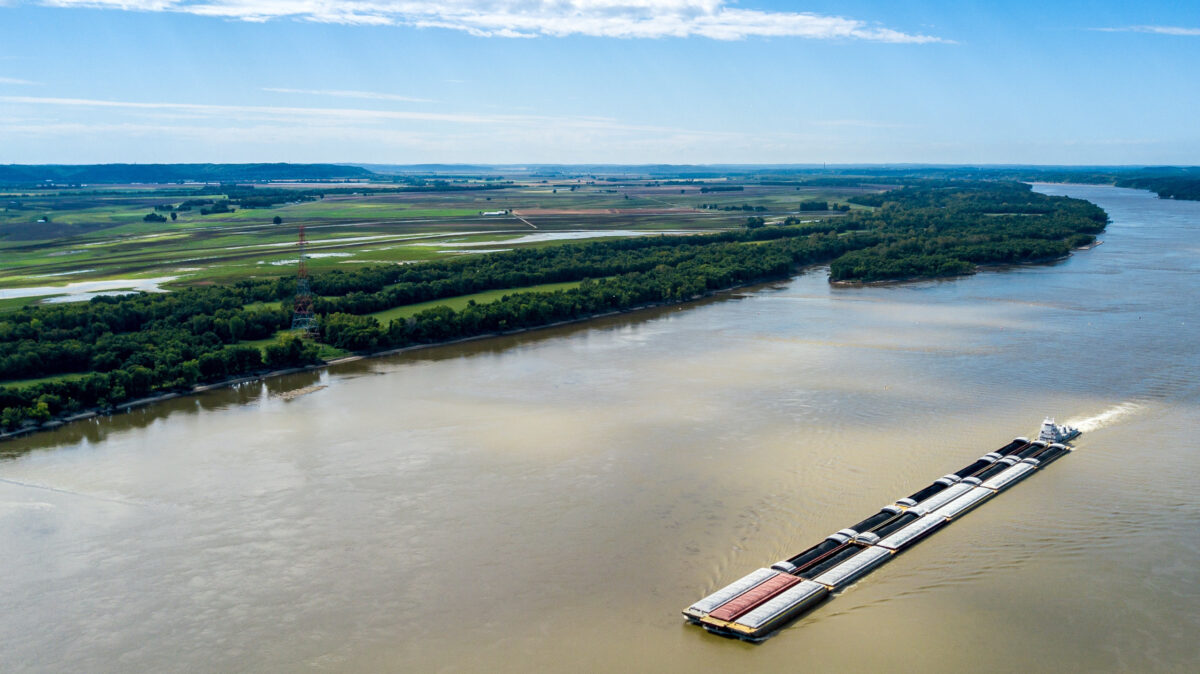
Barges and their tows move approximately 175 million tons of freight each year on the upper Mississippi through a system of 29 locks and dams. It also provides a huge form of recreation for people in many states. The Importance of the Mississippi River and its Basin are key ecosystems in North America, besides the important role of water distribution management, it plays for the center of the USA.
The Mississippi River Basin
- Holds around 260 species of fish. 25% of all the fish that live in North America live in the Mississippi River.
- 40% of the nation’s migratory waterfowl use the river corridor during their spring and fall migration. 60% percent of all North American birds (326 species) use the Mississippi River Basin as their migratory flyway.
- From Cairo, IL, upstream to Lake Itasca, there are 38 documented species of mussel. On the Lower Mississippi, there may be as many as 60 separate species of mussels.
- The Upper Mississippi is host to more than 50 mammal species. At least 145 species of amphibians and reptiles inhabit the Upper Mississippi River environs.
The Great Mississippi River Road
Did You Know That?

The Great River Road National Scenic Byway follows the course of the Mississippi River for 3,000 miles from northern Minnesota to the Gulf of Mexico. The scenic route passes through 10 states and hundreds of river towns. The Great River Road is arguably the longest and most important scenic byway in America.
The drive takes around 36 hours. It takes most people about 6-10 days to travel the route. The whole route is laid out with well-marked signs. The familiar pilot’s wheel symbol denotes which roads are part of the designated route.
The route has been selected for its natural, cultural, historical, recreational, and scenic properties. It’s the only organization that unites all 10 states north and south along the Mississippi River corridor.
All along the Great River Road National Scenic Byway, you’ll find tourist amenities as well as Interpretive Centers that help travelers experience the many facets of the Mississippi River Region.
The MRC The Mississippi River Country USA was established in 1986 to use the global awareness of the Mississippi River for marketing the 10 states along the river, in their entirety, both domestically and to countries throughout the world. Download their Brochure- The Mississippi Parkway Commission Brochure
Where Does the Rio Grande River Start and End?
The Upper headwaters of the Rio Grande River originate in Colorado high in the San Juan Mountains & the Continental Divide flows south through the San Luis Valley in Colorado, then to Albuquerque & Las Cruces, NM it continues south across the Texan border & ends at the mouth of the Gulf of Mexico.………………………………………………….. Read
Mississippi River: A Journey from the State Park Headwaters to the End
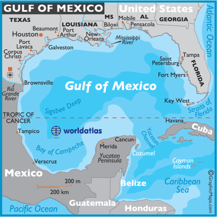
The Mississippi River ends and empties into the Gulf of Mexico about 100 miles (160 km) downstream from New Orleans. That area where the river empties into the Gulf right off the coast of Louisiana is what’s called the Dead Zone. The size of the Dead Zone has reached larger sizes over the years among scientists and researchers. A dead zone is an area in the ocean that has a low amount of dissolved oxygen.
Scientists call this ocean environment hypoxia. Which means the water contains no oxygen. It can no longer support the life that would typically call that area home. When it starts to appear in the spring in the northern part of the Gulf of Mexico, it often causes die-offs of corals, aquatic plants, shellfish, and other smaller fish.
The size of the Dead Zone has been growing since the early 1970s, and this year, Louisiana State University scientist predicts that 2019 will be the size of New Jersey. The NOAA scientific report says they expect it to be even larger. What causes this phenomenon?
One of the sources of The Dead Zone is the seasonal runoff of the Mississippi River coming from thousands of farms along the river that can’t handle the rainfall this past Spring. Too many nutrients from the farm fields, nitrogen, and phosphorus from runoff stimulate the growth of phytoplankton, which settles at the bottom of the river and decomposes with bacteria that use up oxygen, leading to the creation of Dead Zones.
Besides the many farms that line the river, another reason for the low oxygen caused by high nitrogen content was the fact that the Mississippi was contained from spilling over naturally to prevent flooding in rural and urban areas.
End of the Mississippi River: The Mystery of Its Termination Point
The end of the Mississippi River has been a topic of ongoing intrigue, sparking interest among geologists, adventurers, and nature lovers alike. The Mississippi River, one of the longest water bodies in the world, has an intriguingly complex infrastructure not unlike the vast river systems across continents.
Speaking of its end, it’s the mighty Gulf of Mexico that swallows this river giant. Thus, understanding the mystery of the Mississippi River ends in the illustrious Gulf of Mexico. The point at which the Mississippi River ends by flowing into the Gulf of Mexico is an area teeming with a unique ecosystem and a bustling hub of economic activity.
The Gulf of Mexico is a massive body of water bordered by the United States, Mexico, and Cuba, with the southern part of the Mississippi River merging into it. With each passing moment, water from the river continues to flow into the Gulf of Mexico, creating fertile alluvial plains, expansive marshy lands, and a rich biosphere in and around its termination point. As the Mississippi River ends in the Gulf of Mexico, it culminates in a spectacular journey that started in the placid waters of its source at Lake Itasca.
Speaking of the river’s source, the Mississippi River starts at Itasca State Park, from a small glacial lake called Lake Itasca. Itasca State Park is a natural marvel in itself, home to varied types of flora and fauna. All streamlets from this region converge to give birth to the Mississippi River, making it a case study for limnologists and ecologists.
Now, it’s crucial to grasp the significance of both poles of the Mississippi River. While the Mississippi River starts in Lake Itasca and flows through the Itasca State Park, nourishing many states in its path, it is where it ends that most of the economic and ecological significance lies.
The point where the Mississippi River ends, the Gulf of Mexico, becomes a conduit for the river to transport vital nutrients, ensuring the sustenance of a vibrant ecosystem. Simultaneously, this point of confluence supports numerous industries, including fishing, tourism, and even oil drilling. In essence, the Mississippi River ending in the Gulf of Mexico signals not just the termination of a geographical course but the beginning of life in several forms.
In conclusion, the course of the Mississippi River, from where the Mississippi River starts at Itasca State Park to where the Mississippi River ends at the Gulf of Mexico, is an intriguing blend of geography, ecosystem dynamics, and socio-economic developments. Tracing its journey provides a comprehensive understanding of natural water bodies’ impact and importance on Earth. However, the one mystery remains – the exact termination point in the Gulf of Mexico. Intriguing, isn’t it?

The river’s excess water was always absorbed naturally, as it has been for thousands, by seeping into belts of natural vegetation along the river, called riparian zones, and into wetlands.
Both riparian zones and wetlands act as filters, cleansing flood water and improving water quality along the Mississippi River system of excess nutrients all along the courses of the river.
The great American River flows from its source at Lake Itasca in northern Minnesota, where the mighty Mississippi River begins. The National River protects from flooding in Ohio, Indiana, Illinois, and Iowa have drained more than 80 percent of their wetlands.
Indiana, Illinois, Iowa, Minnesota, Missouri, and Wisconsin collectively have lost 35 million acres of wetlands over the past 200 years. A sewage treatment plant in Minnesota in the Upper Mississippi can have an effect at the mouth of the Gulf of Mexico.
The end of the Mississippi River is around 100 miles downstream from New Orleans, finishing off the 2348-mile run, draining 31 states and going through 10. Today, the Mississippi River powers a significant segment of the economy in the upper Midwest.
In the last decade, Congress has set aside large amounts of money to research and fund a program to open some of the dams upstream in the Mississippi that will allow water to be spilled over to natural wetlands. We can hope that a little at a time might make a difference in the future of the Mississippi River system.
Mississippi Headwaters Board (MHB)
Protection of the Mississippi River has been adopted by local government in this region. The basic tool for protection is an ordinance that limits land use in the river corridor. This ordinance is administered by the Mississippi Headwaters Board (MHB), a joint powers board of Clearwater, Hubbard, Beltrami, Cass, Itasca, Aitkin, Crow Wing, and Morrison counties.
Controlling development controls human disturbances of the river bank and its watershed that can increase erosion, disturb animal habitat, and consequently, impair water quality. It is an effective tool. However, it is a limited tool. Maintaining the health of the river and its ecosystem is the ultimate goal of the MHB’s river protection program.
In 2016, the Mississippi Headwaters Board developed a program in partnership with the Board of Water and Soil Resources and The Trust for Public Land to protect critical fish and wildlife habitat values on private land that lies on the Mississippi River, headwaters lakes and reservoirs, and contributing tributaries. The program uses Outdoor Heritage funds created from the Clean Water Land and Legacy constitutional amendment to create and expand contiguous habitat complexes of permanently protected shoreland.
Conclusion:
The Mississippi watershed is the third-largest in the world and plays a key role in the environmental aspects of a major portion of the country, covering over 41% of the USA along with parts of two Canadian Provinces. The great Mississippi starts as a tiny outlet stream from Lake Itasca in Northern Minnesota. Making its way on a 2,350-mile journey south joined by hundreds of tributaries draining 31 states, The Ohio & Missouri Rivers & ending at about 100 miles downstream of New Orleans in the Gulf of Mexico.
Where is the Columbia River located?
The Columbia River is located in the Pacific Northwest region of North America rising in the Rocky Mountains of British Columbia, Canada into Washington State & Oregon before emptying into the Pacific Ocean at Astoria, Oregon. Its drainage basin extends .………………………………………………………………. Read more
A: The Mississippi River starts at Lake Itasca within Itasca State Park, located in Minnesota. It begins as a small stream that flows from the lake and grows larger as it travels southward.
Q: How long is the Mississippi River?
A: The Mississippi River is approximately 2,350 miles (2,340 miles as mentioned in the text) long, making it one of the longest rivers in North America.
Q: Does the Mississippi River pass through different states?
A: Yes, the Mississippi River flows through ten states, from its humble beginnings in Minnesota to its dramatic end in the Gulf of Mexico.
Q: What is the significance of Itasca State Park about the Mississippi River?
A: Itasca State Park in Minnesota is significant as it is home to Lake Itasca, which is recognized as the source of the Mississippi River. It is a natural gem often frequented by nature enthusiasts and those interested in the geography of the river.
Q: Where does the Mississippi River end?
A: The Mississippi River ends in the Gulf of Mexico. The river flows southwards from Minnesota and eventually pours into the Gulf, which lies along the coastlines of states like Texas, Louisiana, Mississippi, Alabama, and Florida.
