
In 1792, the government decided that it was Kentucky that owned the Ohio River and not the other bordering states of this valuable major trade route but ownership rights of the 3rd largest river by volume in the United States didn’t end there. Where does the Ohio River start and end?
The Ohio River starts at the confluence of the Allegheny & Monongahela Rivers in Pittsburgh, Pennsylvania, and ends in Cairo, Illinois, where it flows into the Mississippi River. The Ohio River is located at the boundary of the Midwestern and Southern United States, flowing southwesterly 981 miles long.
Technically, the river’s formation started between 2.5 and 3 million years ago, marking the occurrence of the earliest ice ages. This is also when several portions of the north-flowing rivers were dammed thanks to the formation of ice, resulting in smaller rivers.
Introduction:
With immense historical and geographical significance, the Ohio River has been a potent symbol of the American journey for centuries. Its 981-mile journey weaves a fascinating tale of ecology, history, and civil life that culminates in one of the most important waterways in the United States. In this article, we shall embark on an enlightening voyage to discover where this mighty river originates and where it concludes, along with intriguing facts about the Ohio River that strengthen its standing as an iconic American landmark.
Origin and Course of the Ohio River in the United States
The Ohio River, a significant waterway in the United States, has an entirely fascinating course and origin. The place where the Ohio River starts or begins is in the northern part of the state famous for its song, Allegheny Mountains of Pennsylvania. This river’s starting point is confluence, a junction formed by joining the Allegheny and Monongahela rivers at Pittsburgh, Pennsylvania. That’s where the Ohio River begins its long, winding journey.
The Ohio River flows through or borders six states: Illinois, Indiana, Kentucky, Ohio, Pennsylvania and West Virginia. In addition, water from parts of New York, Virginia, North Carolina, Tennessee, Maryland, Mississippi, Georgia and Alabama drain into tributaries that empty into the Ohio.
Historically significant and full of natural allure, the Ohio River flows like a liquid ribbon, weaving through five U.S. states. It meanders on, touching West Virginia, Ohio, Kentucky, Indiana, and finally, Illinois. In each of these states, it forms part of their borders, creating a W-shaped path that’s distinctive and unique as the river itself.
Contrary to the repetitive questioning about where the Ohio River starts, the end of the point where the Ohio River isn’t static. It’s a ceaseless, natural flow. As thrilling as its start, the end of this river is just as fascinating. The river culminates in a confluence with the mighty Mississippi River at Cairo, Illinois. Here, its waters blend with the Mississippi, continuing the journey toward the vast Gulf of Mexico. It’s in this sense that you can say the Ohio River ends.
Despite its place in geography, the Ohio River is more than just a river. It’s a crucial part of the continent’s circulatory system, supplying life-giving water across a considerable swathe of the United States. With its profound influence on the ecology and commerce of the areas it flows through, the river’s importance cannot be underestimated. The Ohio River’s massive watershed is also a major drainage area of the U.S. It’s this combination of environment, economics, and geography that makes the Ohio River stand out.
No thorough understanding of America’s geography is complete without comprehending the place the Ohio River holds. This river is a lifeblood conduit between the eastern seaboard and the midwestern states. Its waters have borne explorers, pioneers, and modern-day travelers, facilitating a flow of people, ideas, and goods that have helped shape the nation.
So, whether you’re simply curious about where the Ohio River starts and ends or are a student seeking answers, you now have the facts. From its starting point high in the Allegheny Mountains of Pennsylvania to where it meets the Mississippi River, the Ohio River has a course full of stories and significance. It illustrates that rivers are more than just bodies of water; they’re a pulsating, flowing testament to the land’s topography and its history.
 In the Hills of Pennsylvania, wet trails turn into brooks and streams so small they are hard to trace but all meet with each other to then turn into bigger streams and springs that eventually appear as a river.
These are headwaters of The Ohio River located near Coudersport, Pennsylvania.
The Allegheny River with its source in Allegheny Township in Pennsylvania joins a secondary source the Monongahela River at Fairmont, West Virginia.
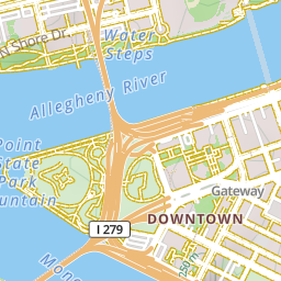
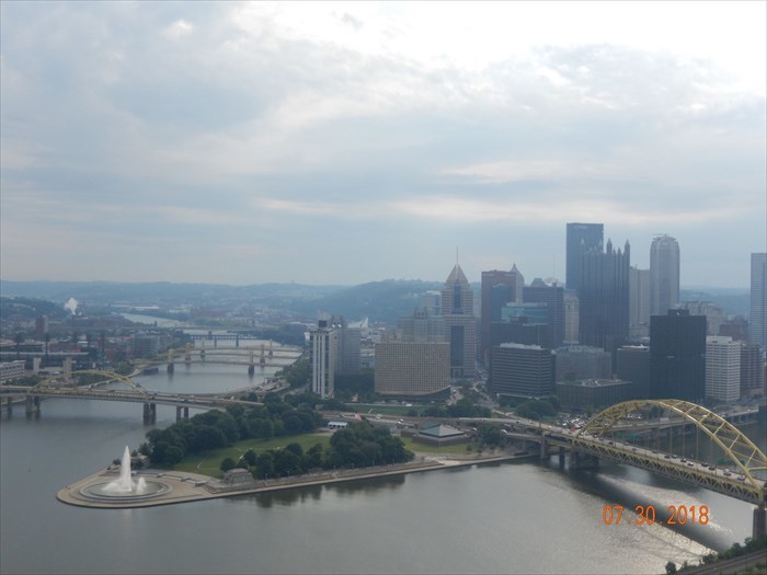
The Allegheny River joins the Monongahela near Pittsburgh to form the Ohio River.
Elevation: 233m / 764feet
This is the famous Three Rivers of Pittsburgh where the Allegheny and Monongahela Rivers meet to form the Ohio River. The exact coordinates are N 40° 26.509 W 080° 00.785
The Rivers in the United States that Source the Ohio River
- The Monongahela River runs 128 miles and is one of the few major navigable rivers in the world that runs north. It starts at Fairmont, West Virginia, and flows north into Pennsylvania. Monongahela is derived from a Native American Word meaning “high banks or bluffs”
- The Allegheny River runs 325 miles from Porter County, PA into New York state, and back into Pennsylvania. The name comes from the Lenape Native Americans and is commonly believed to mean “fine river”.
- The Ohio River runs 981 miles ending at Cairo, IL, and is the largest tributary to the Mississippi River. The name comes from an Iroquoian word meaning “great river”.
The Ohio River is 981 miles (1582 km) long, starting at the confluence of the Allegheny and the Monongahela Rivers in Pittsburgh, Pennsylvania, and ending in Cairo, Illinois, where it flows into the Mississippi River.
Where Ohio joins the Mississippi is the lowest elevation in the state of Illinois, at 315 feet (96 m) The Ohio River flows through or borders six states: Illinois, Indiana, Kentucky, Ohio, Pennsylvania, and West Virginia.
The mouth of the Ohio River, where it empties into the Mississippi, is located in Cairo, Illinois at the spot where it meets Ballard County, Kentucky. Along the way, it has nearly a dozen tributaries that feed into the river.
These include the Kentucky River, the Tennessee River, the Cumberland River, the Great Miami River, the Kanawha River, and the Big Sandy River. From there these tributaries make up the watershed of the Ohio River which ends up running into the Mississippi and then draining into the Gulf of Mexico.
The Role of the Ohio River in United States History
The Ohio River is rich in Native American history. For a thousand years, Native Americans used Ohio for transportation and trading with other communities along its path. The North American Osage, Omaha, Ponca, and Kaw peoples lived in the Ohio Valley. Under pressure over the fur trade from the Iroquois nations to the northeast, they migrated west of the Mississippi River in the 17th century to the territory now defined as Missouri, Arkansas, and Oklahoma.
It is the third-largest river by discharge volume in the United States and the largest tributary by volume of the north-south flowing Mississippi River. Ohio is located in the eastern half of the US, dividing the mid-west and the southeast of the United States.
It is also the 6th oldest river on the North American continent considered geologically as young. During the Civil War, it served as the boundary between the Northern and Southern armies.
 René-Robert Cavelier, Sieur de La Salle, was a 17th-century French explorer and fur trader who was influential in the Seven Year War or The French and Indian War in North America, is said to have been the first European to see Ohio, in 1669, and he descended it until obstructed by a waterfall.
He also claimed the region watered by the Mississippi and its tributaries for France and named it Louisiana after King Louis XIV. His last expedition to establish fur trading posts failed and cost La Salle his life in 1687. By the treaty of 1763 ending the French and Indian Wars, the English finally gained undisputed control of the territory along its banks.
In the 1750s the river’s strategic importance especially the fork at Pittsburgh in the struggle between the French and the English for possession of the interior of the continent became fully recognized.
During the 1800s, the Ohio River became an important commercial route for residents in Ohio, Kentucky, Indiana, and Illinois. Farmers and manufacturers sent their crops and finished products on flatboats and barges downstream to link up with the Mississippi River and then on to New Orleans.
In-Depth on the Ohio River State Journey: Width, Depth, and Natural Settings
Examining the Ohio River’s journey, it’s evident that this river holds much significance. The river flows not only through Ohio but also through other states, influencing their natural settings profoundly. Diving into the river’s width and depth, it’s a fascinating spectacle to witness. The river water, glistening under the sun, journeys thousands of miles before it finds its end.
The frequencies with which the Ohio River and the Mississippi River intermingle are worth noting. The Ohio River converges with the mighty Mississippi River, making its way from Pittsburgh, right where Pennsylvania, West Virginia, and Ohio conflate. However, the journey doesn’t end here. A few miles down, we hit one of the Ohio River’s most scenic spectacles – Louisville, Kentucky. This city is not merely a set of bricks and stones; it’s where the river unveils its deepest depths and widest widths.
Louisville, Kentucky is much more than a mere milestone along the river. Here, the Ohio River hits some of its utmost velocities, its water rushing past the city as if in a hurry. The river flows at its own pace, and the people of Louisville respect its rhythms. With each dawn, the Kentucky-Ohio boundary is illuminated by the sparkles of the river water. The miles it’s traveled to reach this point profoundly shape the natural setting around it.
From Louisville, the Ohio River continues its journey, traveling many more miles. Yet, every state that it touches is more than a momentary stop. Each state promises a unique chapter in the river’s story, ensuring its river water nourishes lifelines along its way. Ohio, Kentucky – no matter the state, no matter the miles it journeys, the river flows persistently, contributing significantly to the continental United States’s river systems.
After a long journey through multiple states, including Ohio and Kentucky, the Ohio River meets the Mississippi River, marking its endpoint. Here, the Ohio River meets its final destination – the Mississippi River. But, the journey doesn’t just draw to a conclusion at the Mississippi River. The river water from the Ohio River merges with that of the Mississippi River, symbolizing an end as well as a new beginning, imparting life to a significant part of the United States.
In all, the Ohio River is much more than a water body flowing across states, journeying miles, linking with the Mississippi River. It’s a lifeline, a symbol of persistence, and a definitive testimony of nature’s prowess. From its width and depth to its natural setting and state-wise journey, the Ohio River unravels a fascinating story, proving that every river, every river, indeed, has a tale to tell.
Map of Ohio River Basin United States
The Ohio River flows through or alongside six states: Illinois, Indiana, Kentucky, Ohio, Pennsylvania, and West Virginia. Water from parts of New York, Virginia, North Carolina, Tennessee, Maryland, Mississippi, Georgia, and Alabama drain into tributaries that empty into Ohio.
The Ohio River is the source of drinking water for more than five million people. More than 25 million people, almost 10% of the country’s population, live in the Ohio River Basin.
There are 20 dams on the Ohio River, managed by the Army Corps of Engineers. The dams have greatly altered the flow of the river, calming the currents down, slowing the river down, and creating deeper and slower-moving pools. These Dams raise the water levels and allow for commercial navigation up and down the river.
Industrial barges hauling steel and oil travel along the Ohio River creating commerce for the entire region. Slowing down the river by dams can influence water quality by settling some materials that wouldn’t if the river was moving faster, resulting in lower turbidity.
The Army Corps of Engineers regularly dredge the river which some people feel is disrupting wildlife and adding more environmental concerns to the Ohio River Valley Basin.

Following floods at Johnstown, Pennsylvania, in 1889 and Portsmouth, Ohio, in 1937, the federal government built a series of flood-control dams not used for hydropower along the river flood control. The river has a total fall of 429 feet.
Because the Ohio River was considered a major trade route, border states decided they wanted a piece of the popular river. Soon, it would become a legal dispute with the government getting involved. In 1792, the government decided that it was Kentucky that owned the Ohio River along the state’s border with Ohio, Illinois, and Indiana. The reason behind this decision is that this boundary was the low point of the river’s northernmost bank but it didn’t end there.
About two centuries later, the State of Ohio sought to gain the claim to the Ohio River a second time. In 1966, the state made a point that the course of the river had fluctuated since 1792, making the aforementioned low point near the south bank of the river today. However, the United States Supreme Court didn’t change the legal ownership of the Ohio River, so it still belongs to Kentucky to this day.
Key Takeaways from Lessons Learned About the Ohio River
The Ohio River, often hailed as a symbol of America’s natural splendor and history, presents a myriad of interesting facts and unique attributes. Starting in western Pennsylvania and West Virginia, this expansive river meanders its way through several states before ultimately ending its journey by feeding into the mighty Mississippi River.
Through the countless data Ohio’s staff have amassed over the years, we’ve gathered intriguing details about this vast waterway, painting a vivid image of its significance. The river, whose name originates from an Iroquois word meaning “Great River,” indeed lives up to its moniker. Its vastness is merely one of the fascinating aspects of this river.
Largely fed by many smaller rivers across numerous states, the framework that comprises the Ohio River basin is an intricate network of contributing waterways. The facts we’ve gleaned remind us of the river’s integral role in the history and geographical makeup of the United States. The staff tirelessly works to conserve and study the prominent natural feature that is the Ohio River.
One of the many insights gained from studying the Ohio River centers on its role in United States history. This river was a significant transportation route during America’s westward expansion, shaping the nation’s growth and development. Accordingly, the river’s journey through various states tells stories of past eras, each town along its banks whispering tales of its engagement with the Ohio River.
Furthermore, the river’s size and reach are awe-inspiring. Traversing through multiple states, the Ohio River’s width, depth, and natural settings reveal an impressive range. The river water’s variation in depth and flow due to the river’s winding trajectory and change of seasons showcases nature’s ability to continually morph and adapt.
Recognizing the facts about the Ohio River, our staff have come to appreciate its intrinsic value. Not only does it sustain life and commerce through its river water, but it also links different states, creating a more cohesive United States.
In a broader sense, it’s the lifeline of the region, providing drinking water and serving as a critical component of many ecosystems.
Virginia, one of the numerous states linked by the Ohio River’s trajectory, shares a deep-rooted connection with this waterway, its history closely intertwined. This connection is a strong reminder of the river’s past and an insight into how it continues to shape regions.
Amidst the vital lessons learned from studying the Ohio River, perhaps the main takeaway is understanding its profound and lasting impact. From its genesis to its ending, this river is more than a body of water. It’s a testament to the resilience of nature, and a constant reminder of our country’s rich history.
With data Ohio’s staff continue to collect, collate, and analyze, we expect to unearth more riveting information about the Ohio River. We’re committed to protecting this resource, salvaging its inherent splendor, and maintaining the harmonious balance of life it supports.
Where does the Missouri River Start and End?
The Missouri River a tributary of the Mississippi starts in Three Forks, Montana, as the confluence of 3 major rivers, Madison, Jefferson & Gallatin & ends in St. Louis, Missouri. Crossing South Dakota, North Dakota, Nebraska, Iowa, Colorado, and Kansas, & at 2,540 mi. is the longest river in the US.………………………………………… Read more
How Deep Is the Ohio River
The widest point along the Ohio River is approximately 1 mile at the Smithland Dam near Smithland, KY. The river has an average depth of approximately 24 feet. The Ohio River supports 160 species of fish. There are 20 locks and dams on the Ohio River for flood control and navigation. There are 38 power-generating facilities on the Ohio River.
The river’s deepest point is 168 feet (51 m) on the western side of Louisville Kentucky. From Louisville, the river loses depth very gradually until its confluence with the Mississippi at Cairo Illinois where it has an approximate depth of 19 feet (6 m). Velocities or how fast the water moves on the Ohio River can range from 0.1 mph under low flow to 5 mph at flood stage
Where does the Colorado River Start and End?
The Colorado River begins at La Poudre Pass in the Southern Rocky Mountains of Colorado, at 10,184 ft above sea level. After a short run south, it turns west below Grand Lake, then south at 1,450 mi. gaining strength from many tributaries to the Sea of Cortez in northwestern Mexico, where it ends..…………………………………………………… Read more
How Deep Is the Ohio River
The widest point along the Ohio River is approximately 1 mile at the Smithland Dam near Smithland, KY. The river has an average depth of approximately 24 feet. The Ohio River supports 160 species of fish. There are 20 locks and dams on the Ohio River for flood control and navigation. There are 38 power-generating facilities on the Ohio River.
The river’s deepest point is 168 feet (51 m) on the western side of Louisville Kentucky. From Louisville, the river loses depth very gradually until its confluence with the Mississippi at Cairo Illinois where it has an approximate depth of 19 feet (6 m). Velocities or how fast the water moves on the Ohio River can range from 0.1 mph under low flow to 5 mph at flood stage
Conclusion
In 1792, the government decided that it was Kentucky that owned the Ohio River and not the other bordering states of this valuable major trade route but ownership rights of the 3rd largest river by volume in the United States didn’t end there. The Ohio River is at the boundary of the Midwestern and Southern United States, flowing southwesterly 981 miles (1582 km) long, starting at the confluence of the Allegheny & the Monongahela Rivers in Pittsburgh, Pennsylvania, and ending in Cairo, Illinois, where it flows into the Mississippi River.
Technically, the river’s formation started between 2.5 and 3 million years ago, and that point marks the occurrence of the earliest ice ages. This is also when several portions of the north-flowing rivers were dammed thanks to the formation of ice, resulting in smaller rivers.
Where Does the Hudson River Start and End?
The Hudson River headwaters start high in New York’s Adirondack Mountains near Mount Marcy sourced by Lake Tear & Opalescent River, Essex County runs southward 315 miles through Hudson Valley & Upper New York Bay between New York City & Jersey City emptying into .………………………………………………………………………… Read more
![]()
References: History Channel-The Seven Year’s War
Biography-René-Robert Cavelier, Sieur de La Salle
Ohio River Valley Water Sanitation Commission
FAQ’s
- Where does the Ohio River start and end? The Ohio River begins at the confluence of the Allegheny and Monongahela Rivers in Pittsburgh, Pennsylvania, and flows southwest for about 981 miles before emptying into the Mississippi River near Cairo, Illinois.
- What states does the Ohio River run through? The Ohio River runs through or along the borders of six states: Pennsylvania, Ohio, West Virginia, Kentucky, Indiana, and Illinois.
- What is the significance of the Ohio River? The Ohio River is significant for transportation, recreation, and as a water source. It played a vital role in the westward expansion of the United States and continues to be important for commerce and tourism.
- Is the Ohio River polluted? Like many rivers, the Ohio River faces pollution challenges from agricultural runoff, industrial discharge, and urban runoff. Efforts are ongoing to improve water quality and mitigate pollution.
- What wildlife can be found in the Ohio River? The Ohio River is home to a diverse array of wildlife, including fish such as bass, catfish, and sturgeon, as well as birds, reptiles, and mammals like otters and beavers.
- Are there recreational activities along the Ohio River? Yes, the Ohio River offers various recreational activities such as boating, fishing, camping, and birdwatching. Many parks and trails are situated along its banks, providing opportunities for outdoor enthusiasts.
- Has the Ohio River experienced floods? Yes, the Ohio River basin is prone to flooding, with historic floods occurring periodically. Flood control measures, such as dams and levees, have been implemented to mitigate the impact of flooding.