
The Colorado River is the Lifeblood of the American Southwest. Its power provided by the amount of water flowing through it and the area it covers all allows for it to be used for many purposes, including irrigation, a water source, and a source of Hydroelectric power for the town and cities all along the way. Where does the Colorado River Start and End?
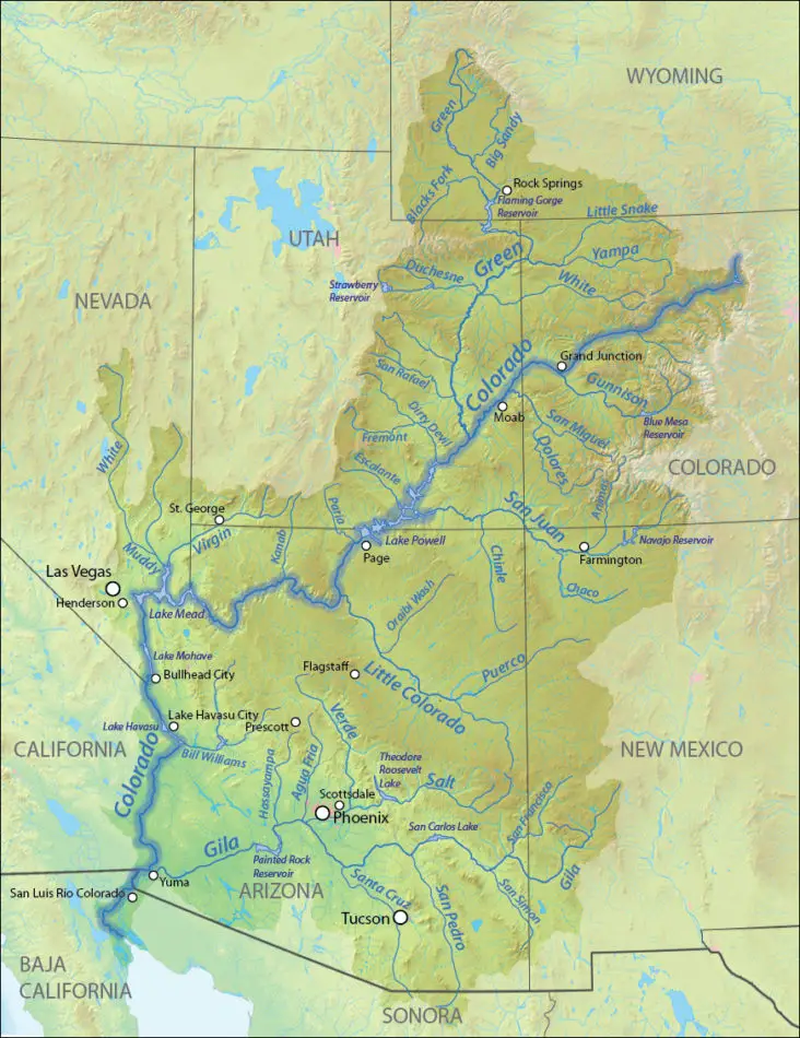
The Colorado River begins at La Poudre Pass in the Southern Rocky Mountains of Colorado, at 10,184 ft above sea level. After a short run south, it turns west below Grand Lake, then south at 1,450 mi. gaining strength from many tributaries to the Sea of Cortez in northwestern Mexico, where it ends.
Along with the way great Colorado River in Wyoming, Colorado, Utah, New Mexico, Nevada, Arizona, and California. For 17 miles, the river forms the international boundary between the U.S. state of Arizona and Mexico.
Introduction
Welcome to our guide about the Colorado River and its Basin. This American river flows for 1,450 miles, from the Rocky Mountains of Colorado to the Gulf of California in Mexico. Throughout its journey, it carves out deep canyons, creates fertile valleys, and sustains a vast assortment of flora and fauna. The river, in this guide, we’ll provide detailed insights into its origin, the route it takes, and its ultimate destination. Understanding the journey of the Colorado River isn’t just about geographical knowledge; it’s a peek into the birth and diversity of planet Earth.
Where Does the Colorado River Start and End: The Colorado River’s Journey

The question of where the Colorado River starts and ends can be a truly engaging topic for exploration. This grand river, referred to as Colorado’s lifeline, starts its journey on the Continental Divide in Colorado’s Rocky Mountain National Park. It’s here, in this beautiful national park, that the river starts trickling down, beginning its descent towards its final destination. The starting point is quite scenic, providing an excellent representation of Colorado’s unique and diverse landscapes.
From its starting point high in the mountains, the river makes its descent, flowing through various states in the United States. Its journey is not just a geographical course, but also a story of the diverse ecosystems and communities that exist along its banks. The river’s flow can be thought of as a living file, a record of the natural and human history that it has witnessed and helped shape.
After its long journey, where does the Colorado River end? It ends up flowing into the Gulf of California, a major marine habitat teeming with life. Here, the Colorado’s waters mingle with those of the ocean, the final endpoint of a river that has woven its path through numerous terrains and states. The end of the river is as dramatic as its beginning, marking the completion of an epic journey.
As per Britannica and other credible sources, the Colorado River is recognized as one of the major rivers of North America. Its course is not just an impressive geographical feature, but also a crucial component of the water system sustaining numerous communities and ecosystems. Its story is representative of the dynamism and vitality that characterizes Colorado, a state known for its natural beauty.
Understanding the river’s journey, from where it starts to where it ends, is a way to appreciate its role in shaping the worlds it goes through, from human habitats to natural ecosystems. It underscores the importance of rivers and water resources, reminding us of our responsibilities towards these vital lifelines. Indeed, the journey of the river Colorado, from its start on the continental divide in Colorado’s Rocky Mountain National Park to its end in the Gulf of California, provides an awe-inspiring glimpse into the power and beauty of nature.
The Colorado River Starts: A Journey Through the Basin
The Colorado River, one of the most essential waterways in the United States, provides a fascinating journey from start to end. It begins high in the Rocky Mountains of Colorado near the Continental Divide. This popular river basin, known as the Colorado Basin, showcases a diverse landscape as the river flows through it. Being the cornerstone of the southwestern United States’ natural and economic systems, the Colorado River’s flow presents an incredible story. The river travels its path, sculpting remarkable landscapes, providing necessary water supplies to cities, and sustaining various ecosystems. This basin, which the Colorado River runs through, becomes the site of a significant segment of this incredible journey.
The Colorado River starts its trek at La Poudre Pass in the Rocky Mountains. As the Colorado River begins, it is just a small stream flowing through a thin layer of snow. Over the course of nearly 1,450 miles, the river grows in strength. By the time it reaches the Gulf of California in Mexico, it reshapes the terrain and nourishes life in the Colorado basin. Throughout this journey, the Colorado River’s breadth and depth fluctuate substantially as it winds through changing landscapes. The riverbed itself evolves from a shallow incline to deep, steep-sided canyons.
The river flows in various directions throughout its course, but its general trajectory goes from northeastern Colorado down to the southwestern corner of the basin. This river travels through seven U.S. and two Mexican states, providing vital water resources along its path. The Colorado River Basin serves as a lifeline for approximately 40 million people and numerous wildlife species.
The diverse ecosystem supported by the river features plants and animals uniquely adapted to desert life. As the river flows, it creates habitats that these species rely on for survival. This cycle reinforces the importance of maintaining the Colorado River’s health and ensuring the continued flow of the river.
Understanding where the Colorado River starts and how it affects the Colorado Basin is crucial for grasping the full scope of the waterway’s influence in the United States. The Colorado River’s journey offers a spotlight on how crucial these waterways are to the balance and sustainability of both human and natural life across the regions it traverses.
Understanding the Colorado Basin’s Role in River Flow
The journey of the Colorado River begins high in the Rocky Mountains. Spanning across seven U.S. and two Mexican states, the River plays a vital role in supplying clean water to millions of inhabitants. The crucial factor that determines the river’s flow is the Colorado Basin, which acts as the river’s catchment area.
To understand the Colorado Basin’s role in the river flow, it’s important to dive deep into the Basin’s geographical characteristics. Situated mostly in the Colorado Plateau, the Basin spreads over portions of seven Western states. The Basin is an expansive and intricate system that collects water from numerous tributaries and channels it into the primary course of the Colorado River.
The basin’s contribution to the river’s flow is significantly dependent on the snowmelt and rainfall within its region. The precipitation in the Basin’s region, whether in the form of rain or snow, contributes to the river’s water. In other words, the Basin serves as a gigantic natural funnel, gathering the precipitation and directing it into the river’s course. Thus, the flow of the river is heavily influenced by the environmental conditions within the Basin.
Interestingly, not every drop of water that reaches the banks of the Colorado River ends up in the Gulf of California, the river’s endpoint. A considerable portion of the river’s water is used along its course. Roughly 40 million people rely on the Colorado River’s water for their drinking needs, and about 5.5 million acres of land are irrigated by it. Unfortunately, intense demands on the river’s water, combined with the impacts of climate change, are causing a significant decrease in the river’s flows.
The Colorado River’s path is dotted with several dams and reservoirs, each with its specific role in regulating the river flows. These artificial structures manage the release of river water, reducing flood risks and ensuring a consistent supply of water during periods of drought. However, they also contribute to alterations in the river’s natural flow.
In conclusion, the journey of the Colorado River is a complex one, strongly shaped by the interaction between the various elements of its environment. While the Colorado Basin plays a central role in maintaining the river’s flow, human activities and climate factors also significantly shape the river’s final journey. Gaining a deeper understanding of this complex interaction is key to gaining valuable insights into the river’s health and sustainability for future generations.
USGS: The Colorado River’s Journey From Start to End
The Colorado River’s journey, from where it starts to where it ends, is a remarkable expedition that stretches over 1,450 miles. According to the United States Geological Survey (USGS), the Colorado River begins its trip in the Rocky Mountains of Colorado, specifically in the state’s La Poudre Pass Lake. From there, it tirelessly travels across Colorado’s rugged landscapes, descending towards the lowlands of the southwestern United States.
The Colorado River’s path takes it through seven US states before finally reaching its end at the delta, spilling into the Gulf of California. Along the way, the Colorado River shapes monumental landscapes such as the Grand Canyon, providing life-sustaining waters to countless ecosystems. The Colorado River stands as a symbol of the United States’ natural beauty and the importance of water resources.
The USGS has mapped the entire course of the Colorado River, offering critical insights into how this key waterway behaves and adjusts over time. These studies help us comprehend the role of the Colorado River in providing water to millions of people and the extensive biodiversity within the United States. They are necessary to manage the river’s health and the vital resources it offers.
However, where the Colorado River starts and ends is just a part of the story. The true importance of the Colorado River is found in its journey the life it nurtures and the communities it sustains.
From its beginnings in the mountains to its end at the delta, the Colorado River is a powerful force that shapes the face of the southwestern United States. Understanding this mighty river’s journey is essential to appreciating its significance and protecting its future.
The Colorado River’s journey, both its start and end, remains a source of awe and inspiration. The river’s perennial journey from the Colorado mountains to the delta has awed generations. The USGS, in their study of this river, have not just charted a geophysical course they have traced the pulse of one of nature’s most remarkable phenomena.
Where the Colorado River begins, it transforms environments; where the Colorado River starts, it sparks life; and where the Colorado River ends, it deposits the richness it collected throughout its journey. So, the Colorado River’s adventure paints a bigger picture, a testament to the living beauty and resilience of nature, and a reminder of how interconnected US river systems all are in the grand scheme of things.
How Does the Colorado River End at the Delta?
The Colorado River, a crown jewel among the waterways of the United States, embarks on a journey that ultimately leads it into the Gulf of California. But how does this river’s journey end? What happens when the Colorado River reaches its delta? This portion of the river’s voyage is truly a marvel to comprehend.
The Colorado River, well known for its lengthy route, plunges in from the Rocky Mountains and cuts through several states before reaching its final destination. At the end of the river’s journey, the delta, historically spread its water and nourishing sediments into the Gulf of California, contributing to the health and livelihood of the ecosystem there.
However, the Colorado River’s contemporary journey paints a different picture. As the river travels downstream, it passes through several man-made infrastructures; dams, reservoirs, and diversions for urban and agricultural uses. These have dramatically reduced the flow of water that naturally would reach the end of the river and ultimately the delta. It’s essential to acknowledge that, in most years, the Colorado River, in fact, doesn’t even reach the Gulf of California, it runs dry before it gets there.
Even though the Colorado River’s journey doesn’t end in the Gulf of California as it did historically, certain amounts of its water do make their way into the gulf. Some of this water is surplus from irrigation practices along the river’s course, seeping underground to join the river’s flow or pouring directly into the river’s channel. Typically, this surplus water tends to be significantly tainted with agricultural residues and doesn’t add much qualitative value to the Colorado River’s end into the gulf.
Despite these challenges, various environmental organizations and governments are working together to restore the Colorado River delta. Plans include releasing ‘pulse flows’ – large volumes of water to mimic the river’s natural spring floods, which can revitalize the delta. Yet, it is a tug-of-war between the use of the river’s water resources and maintaining its natural ecosystem.
To wrap up, the Colorado River’s journey is an intricate story full of turns, twists, and human intervention. The river starts high in the Colorado basin, carving a path through multiple states, catering to millions on its way, and attempts to end in the Gulf of California, at its historic delta. The conversation around this river, its delta, and its end is an ongoing one, as we try to strike a balance between its use and its survival.
Where does the Missouri River Start and End?
The Missouri River a tributary of the Mississippi starts in Three Forks, Montana, as the confluence of 3 major rivers, Madison, Jefferson & Gallatin & ends in St. Louis, Missouri. Crossing South Dakota, North Dakota, Nebraska, Iowa, Colorado, and Kansas, & at 2,540 mi. is the longest river in the US……………………………………………………. Read more
Colorado: The River’s Role in the State
The Colorado River plays a crucial role in the state of Colorado, United States. As a major river in the United States, it flows through Colorado sustaining life and communities along its path. Also known as River Colorado, it indeed becomes a journey, a journey through the basin as its water flow affects the Colorado Basin’s role.
It’s quite the spectacle to see the river’s journey from start to end. According to the USGS, this vast Colorado River starts at La Poudre Pass in the Southern Rocky Mountains of Colorado, United States. Melted snow and rain collect to form an impressive water stream that nourishes the soils of Colorado. From its small beginnings high in the mountains, it embarks on a long path, changing Colorado’s landscapes, forging valleys, and feeding various ecosystems.
As part of its journey, the river takes a course from the northwestern part of Colorado, United States, meandering through majestic canyons, sweeping plains, and arid desert regions. The river is an integral part of Colorado’s identity, mirrored in its name Colorado’. Observing this river’s journey is to understand the natural flow of life from resilience to unity.
This Colorado river threads through seven United States and two Mexican states before ultimately emptying into the Gulf of California. This river, which houses several fish species and serves as a water source for the vast agricultural lands of Colorado, reflects Colorado’s struggle and the people’s adaptability to nature’s way.
An interesting part of this river’s journey is the Colorado Delta where it traditionally ends. This delta, once a lush and vibrant aquatic habitat, has now become a parched desert. Yet, it symbolizes the endurance of nature, epitomizing the irreversible journey of the Colorado River.
In conclusion, the river Colorado illustrates an incessant journey that begins and ends within the realm of nature. It fosters life in Colorado, and understanding its journey helps us comprehend how closely we are linked to the natural world. The journey of the water flow and the landscapes it shapes speak volumes about the relationship between nature and the state of Colorado. This river’s journey, from start to end, tells the story of the land it flows through, highlighting the inseparable bond between Colorado and its namesake river, the River Colorado.
Beyond Colorado: The River Basin and its Impact on the Southwest
Moving beyond Colorado, the Colorado River’s mighty flow continues its journey across the southwest. The river’s influence stretches far beyond the borders of Colorado, providing a lifeline to other states in the United States, including northwest Texas.
The river flows from its origins in Colorado, supplying seven states in the United States along the way. Each of these states known collectively as the Colorado River Basin relies greatly on the Colorado River. The river provides fresh water for drinking and irrigation, supporting both urban and rural communities. This swath of states in the United States benefits from the river flows originating in the Colorado River Basin, contributing admittedly to the basin’s strategic importance.
As highlighted in sections “USGS: The Colorado River’s Journey from Start to End”; and “How Does the Colorado River End at the Delta?”, the scale of the river’s impact is astounding. The river flows nearly 1,450 miles from its start in the Rocky Mountains of Colorado to its end in the Gulf of California. But even as it reaches the end of its journey, the river’s influence doesn’t stop. It continues through its deposits into the river delta, impacting the ecology and biodiversity of the area. This is where the Colorado River technically ends, but its influence stretches even further.
The river’s journey beyond Colorado, as we’ve learned, leads it to the southwest areas of the United States. The river flows across an extensive region, making this one of the largest river basins in the United States. Even in northwest Texas, far from the river’s source, people feel the impact of the Colorado River.
To wrap up, the Colorado River’s impact on the Southwest cannot be overstated. As we’ve seen in each mile it travels, every state it bisects, and every person, plant, and animal it sustains, is part of the river’s legacy. It is indeed a testament to nature’s power, the Colorado River’s journey, from Colorado to its end in the southwest, shaping the land and life along its course.
Yukon River flows through the central Yukon territory of northwestern Canada & the central region of the U.S. state of Alaska 1,980 mi. from its headwaters of the McNeil River flowing northwestward then southwestward through a low plateau sloping down across Alaska discharging into the Bearing Sea .………………………………………………….. Read more
Is the Colorado River Drying Up: A Look at Future Trends
Even as the Colorado River flows it also continues to diminish, it raises significant environmental and economic queries. Is the Colorado River drying up? What could this mean not only for Colorado but also for the entire southwestern region?
Recent scientific studies have indicated that the river’s flow is increasingly becoming erratic and volatile, partly due to a combination of
- Warmer temperatures
- Diminished snowfall in the Colorado basin
- Population increases where the river starts, creating a ripple effect.
- Ongoing Drought
These issues among others affect not only the river itself but also the wildlife and communities that depend on it.
The U.S. Geological Survey (USGS) has provided comprehensive data on the Colorado River’s journey from its start to its end. From these readings, it has become evident that the river’s levels are gradually decreasing, contributing to the narrative that indeed, the Colorado River may be drying up.
Primarily, the river starts in the Rocky Mountains of Colorado. It’s here at the Colorado basin where the river gathers momentum, providing essential water resources for Colorado and beyond. The river reach extends into the south, flowing through seven states before it ends at the Delta, where it precipitously drops. As the river flows, it contributes substantially to the economic growth of these regions, supplying water for irrigation, generating hydroelectric power, and supporting recreation and tourism.
However, the future of the Colorado River paints a worrying trend because of ongoing drought. The reality where Colorado sees diminishing river flows year after year is becoming all too familiar. Alarmingly, the Colorado River’s flow fluctuates now more than ever.
Nevertheless, there is still hope. While climate models predict that there will be less precipitation in the area surrounding the Colorado River, it is not necessarily a death sentence for the river. Proactive water management strategies can help deal with decreasing river flows as they happen, ensuring the river Colorado continues to sustain the southwestern United States.
So, is the Colorado River drying up? While trends point towards a future where the Colorado River’s flow is reduced, it is not a foregone conclusion. However, the importance of monitoring the river’s condition, understanding its patterns, and judiciously managing this critical resource cannot be overstressed to ensure the well-being of not just Colorado, but also the vast expanse of the southwest that it impacts.
Conclusion:
Ultimately, the Colorado River’s journey, beginning in the Rocky Mountains and ending in the Gulf of California, is a striking testament to the natural beauty of the American landscape. The river’s course through various terrains and climates weaving a tapestry and ecological diversity.
While the Colorado River continues to face a series of environmental challenges, its enduring presence attests to the remarkable resilience of nature. As we learn more about this iconic waterway, we gain a greater appreciation for its crucial role in our environment and our responsibility to preserve and sustain it for future generations.
Our approach provides a low-cost method to identify where alternative water and growth management strategies may have the most impact and demonstrates that such strategies can maintain a continued water supply for both people and the environment.
Where does the Ohio River Start and End?
The Ohio River is at the boundary of the Midwestern and Southern United States, flowing southwesterly 981 miles (1582 km) long, starting at the confluence of the Allegheny & the Monongahela Rivers in Pittsburgh, Pennsylvania, and ending in Cairo, Illinois, where it flows into the Mississippi River. ………………………………………………………. Read more
JimGalloway Author/Editor
![]()
References:
The Continental Divide through Colorado
Grand Canyon-Horseshoe Bend, Arizona
The Intimate Grand Canyon experience
FAQ’s
A: The Colorado River starts its journey at the Continental Divide in the Rocky Mountain National Park, Colorado. Here, the river trickles down, beginning its descent towards its final destination.
Q: What route does the Colorado River take?
A: The river flows from its starting point in the Rocky Mountains, flowing through various states in the United States. The river travels its path, sculpting landscapes, and sustaining various ecosystems.
Q: Where does the Colorado River end?
A: The Colorado River ends by flowing into the Gulf of California, a major marine habitat teeming with life. Here, the waters of the Colorado mingle with those of the ocean.
Q: What is the importance of the Colorado River?
A: The Colorado River isn’t just about an impressive geographical feature, it is also a crucial part of the water system sustaining communities and ecosystems. It plays a crucial role in shaping the world through which it travels, from human habitats to natural ecosystems.
Q: How has human intervention impacted the Colorado River’s journey?
A: The river’s path is dotted with several dams and reservoirs, each with a specific role in regulating the river flows. These artificial structures manage the release of river water, reducing flood risks, and ensuring a constant supply of water during periods of drought. These also contribute to changes in the river’s natural flow.